
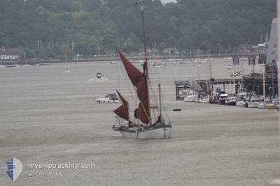
BLUE MERMAID
Sailing
Current Position
| Longitude | 1.75223° |
|---|---|
| Latitude | 52.47211° |
| Status | Default |
| Speed | |
| Course | --- |
| Area | North Sea |
| Station | T-AIS |
| Position Received | 22 h, 20 m ago |
Info
Information
The current position of BLUE MERMAID is in North Sea with coordinates 52.47211° / 1.75223° as reported on 2024-05-31 06:45 by AIS to our vessel tracker app. The vessel's current speed is 0 Knots and is currently inside the port of LOWESTOFT.
The vessel BLUE MERMAID (MMSI: 232021168) is a Sailing It's sailing under the flag of [GB] United Kingdom.
In this page you can find informations about the vessels current position, last detected port calls, and current voyage information. If the vessels is not in coverage by AIS you will find the latest position.
The current position of BLUE MERMAID is detected by our AIS receivers and we are not responsible for the reliability of the data. The last position was recorded while the vessel was in Coverage by the Ais receivers of our vessel tracking app.
Weather
| Temperature | 12.4°C / 54.32°F |
|---|---|
| Wind Speed | 19 knots |
| Direction | 336° NNW |
| Pressure | 1010.7 hPa |
| Humidity | 96.1 % |
| Cloud Coverage | 100 % |
Featured Company
Last Port Calls
| Port | Arrival | Departure | Time In Port |
|---|---|---|---|
| 2024-05-24 09:42 | 2024-05-27 11:25 | 3 d | |
| 2024-05-16 14:47 | 2024-05-21 06:38 | 4 d | |
| 2024-05-01 17:52 | 2024-05-13 15:00 | 11 d | |
| 2024-04-24 16:21 | 2024-04-29 16:24 | 5 d | |
| 2024-04-23 11:11 | 2024-04-24 13:36 | 1 d | |
| 2024-04-23 09:46 | 2024-04-23 10:42 | 56 m | |
| 2024-04-22 21:35 | 2024-04-23 07:51 | 10 h |
Last Trips
| Origin | Departure | Destination | Arrival | Distance | |
|---|---|---|---|---|---|
| 2024-05-21 07:38 | 2024-05-24 10:42 | 10.70 nm | |||
| 2024-05-13 16:00 | 2024-05-16 15:47 | 45.97 nm | |||
| 2024-04-29 17:24 | 2024-05-01 18:52 | 68.18 nm | |||
| 2024-04-24 14:36 | 2024-04-24 17:21 | 16.03 nm | |||
| 2024-04-23 11:42 | 2024-04-23 12:11 | 2.66 nm | |||
| 2024-04-23 08:51 | 2024-04-23 10:46 | 7.17 nm | |||
| 2024-03-14 14:02 | 2024-04-22 22:35 | 175.13 nm |
Events
| Time | Event | Details | Position / Dest | Info |
|---|---|---|---|---|
| 2024-05-31 06:45 | OUT of Coverage |
52.47211 / 1.75224
North Sea
[GB] LOWESTOFT
|
Speed: Course: 163.1° |
|
| 2024-05-31 06:42 | IN Coverage |
52.47213 / 1.75224
North Sea
[GB] LOWESTOFT
|
Speed: 0.1 kn Course: 163.1° |
|
| 2024-05-29 11:58 | OUT of Coverage |
52.47657 / 1.77183
North Sea
|
Speed: 2.7 kn Course: 241.1° |
|
| 2024-05-29 11:38 | START Moving | 1.69 nm, North East of LOWESTOFT |
52.48797 / 1.77823
|
Speed: 3.5 kn Course: 129.4° |
| 2024-05-29 11:25 | STOP Moving | 1.68 nm, North East of LOWESTOFT |
52.49275 / 1.77196
|
Speed: 0.3 kn Course: 511° |
| 2024-05-29 11:20 | IN Coverage |
52.49570 / 1.77028
North Sea
|
Speed: 3.9 kn Course: 152.4° |
|
| 2024-05-29 09:19 | OUT of Coverage |
52.49805 / 1.76698
North Sea
|
Speed: Course: 12.9° |
|
| 2024-05-29 09:07 | STOP Moving | 1.81 nm, North East of LOWESTOFT |
52.49809 / 1.76700
|
Speed: 0.2 kn Course: 511° |
| 2024-05-29 08:26 | IN Coverage |
52.47736 / 1.77686
North Sea
|
Speed: 3.8 kn Course: 334.8° |
|
| 2024-05-29 06:17 | OUT of Coverage |
52.20187 / 1.67148
North Sea
|
Speed: 7.8 kn Course: 16.6° |