
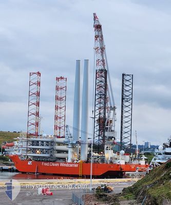
BLUE TERN
Offshore Construction Jack Up
Current Trip
BE OWF
| Time Travelled | 1 day |
|---|---|
| Remaining Time | --- |
| Distance Travelled | 40.54 nm |
| Remaining Distance | --- |
| AVG Speed | 5.8 Knots |
| MAX Speed | 6.6 Knots |
| AVG Wind | 9 knots |
| MAX Wind | 19 knots |
| MIN Temp | 15°C / 59°F |
| MAX Temp | 16°C / 60.8°F |
| Draught | 8 m |
| Position Received | 3 m ago |
Current Position
| Longitude | 13.88785° |
|---|---|
| Latitude | 54.82430° |
| Status | Moored |
| Speed | |
| Course | 85° |
| Area | Baltic Sea |
| Station | T-AIS |
| Position Received | 3 m ago |
Info
Information
The current position of BLUE TERN is in Baltic Sea with coordinates 54.82430° / 13.88785° as reported on 2024-06-19 23:25 by AIS to our vessel tracker app. The vessel's current speed is 0 Knots
The vessel BLUE TERN (IMO: 9598737, MMSI: 215644000) is a Offshore Construction Jack Up that was built in 2012 ( 12 years old ). It's sailing under the flag of [MT] Malta.
In this page you can find informations about the vessels current position, last detected port calls, and current voyage information. If the vessels is not in coverage by AIS you will find the latest position.
The current position of BLUE TERN is detected by our AIS receivers and we are not responsible for the reliability of the data. The last position was recorded while the vessel was in Coverage by the Ais receivers of our vessel tracking app.
The current draught of BLUE TERN as reported by AIS is 8 meters
Weather
| Temperature | 14.5°C / 58.1°F |
|---|---|
| Wind Speed | 19 knots |
| Direction | 300° WNW |
| Pressure | 1019 hPa |
| Humidity | 74.8 % |
| Cloud Coverage | 3 % |
Featured Company
Last Port Calls
| Port | Arrival | Departure | Time In Port |
|---|---|---|---|
| 2024-06-16 19:04 | 2024-06-18 03:12 | 1 d | |
| 2024-06-05 15:48 | 2024-06-07 16:52 | 2 d | |
| 2024-05-28 16:40 | 2024-05-30 13:22 | 1 d | |
| 2024-05-19 06:13 | 2024-05-23 03:25 | 3 d | |
| 2024-05-05 06:45 | 2024-05-07 15:30 | 2 d | |
| 2024-04-22 08:17 | 2024-04-25 08:51 | 3 d | |
| 2024-04-08 05:31 |
Last Trips
| Origin | Departure | Destination | Arrival | Distance | |
|---|---|---|---|---|---|
| 2024-06-07 18:52 | 2024-06-16 21:04 | 78.19 nm | |||
| 2024-05-30 15:22 | 2024-06-05 17:48 | 85.42 nm | |||
| 2024-05-23 05:25 | 2024-05-28 18:40 | 72.40 nm | |||
| 2024-05-07 17:30 | 2024-05-19 08:13 | 68.44 nm | |||
| 2024-04-25 10:51 | 2024-05-05 08:45 | 70.81 nm | |||
| 2024-04-08 07:31 | 2024-04-22 10:17 | 71.93 nm |
Events
| Time | Event | Details | Position / Dest | Info |
|---|---|---|---|---|
| 2024-06-19 20:46 | Status Changed | Moored Restricted manoeuverability |
54.82435 / 13.88798
BE OWF
|
Speed: Course: 85° |
| 2024-06-19 19:23 | STOP Moving | 20.82 nm, North East of SASSNITZ |
54.82549 / 13.88767
BE OWF
|
Speed: 0.2 kn Course: 87° |
| 2024-06-19 18:50 | START Moving | 20.04 nm, North of SASSNITZ |
54.82247 / 13.84181
BE OWF
|
Speed: 3.1 kn Course: 74° |
| 2024-06-19 16:30 | Status Changed | Restricted manoeuverability Moored |
54.80793 / 13.82813
BE OWF
|
Speed: Course: 123° |
| 2024-06-18 11:32 | Status Changed | Moored Restricted manoeuverability |
54.80787 / 13.82809
BE OWF
|
Speed: Course: 123° |
| 2024-06-18 10:26 | Status Changed | Restricted manoeuverability Under way using engine |
54.79795 / 13.82851
BE OWF
|
Speed: Course: 191° |
| 2024-06-18 10:15 | STOP Moving | 18.53 nm, North of SASSNITZ |
54.79860 / 13.82795
BE OWF
|
Speed: 0.3 kn Course: 294° |
| 2024-06-18 08:11 | Detected in Sea | German part of the Baltic Sea |
54.89054 / 14.07646
Baltic Sea
BE OWF
|
Speed: 6 kn Course: 233.5° |
| 2024-06-18 03:12 | PORT DEPARTURE |
|
55.09465 / 14.67750
BE OWF
|
Speed: 3.3 kn Course: 312° |
| 2024-06-18 03:05 | START Moving |
55.09042 / 14.68561
[DK] ROENNE
|
Speed: 3.1 kn Course: 307° |