
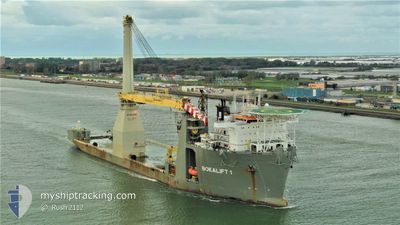
BOKALIFT1
Heavy Lift Vessel
Current Trip
REV OWF
| Time Travelled | --- |
|---|---|
| Remaining Time | --- |
| Distance Travelled | 1165.15 nm |
| Remaining Distance | --- |
| AVG Speed | 8.1 Knots |
| MAX Speed | 12.8 Knots |
| AVG Wind | 11.6 knots |
| MAX Wind | 26.8 knots |
| MIN Temp | 7.1°C / 44.78°F |
| MAX Temp | 21.3°C / 70.34°F |
| Draught | 8 m |
| Position Received | 41 m ago |
Current Position
| Longitude | -70.94681° |
|---|---|
| Latitude | 41.07896° |
| Status | Restricted manoeuverability |
| Speed | 0.2 Knots |
| Course | 165° |
| Area | North Atlantic Ocean |
| Station | T-AIS |
| Position Received | 41 m ago |
Info
Information
The current position of BOKALIFT1 is in North Atlantic Ocean with coordinates 41.07896° / -70.94681° as reported on 2024-06-21 19:33 by AIS to our vessel tracker app. The vessel's current speed is 0.2 Knots
The vessel BOKALIFT1 (IMO: 9592850, MMSI: 212827000) is a Heavy Lift Vessel that was built in 2012 ( 12 years old ). It's sailing under the flag of [CY] Cyprus.
In this page you can find informations about the vessels current position, last detected port calls, and current voyage information. If the vessels is not in coverage by AIS you will find the latest position.
The current position of BOKALIFT1 is detected by our AIS receivers and we are not responsible for the reliability of the data. The last position was recorded while the vessel was in Coverage by the Ais receivers of our vessel tracking app.
The current draught of BOKALIFT1 as reported by AIS is 8 meters
Weather
| Temperature | 21.3°C / 70.34°F |
|---|---|
| Wind Speed | 13 knots |
| Direction | 214° SW |
| Pressure | 1018.9 hPa |
| Humidity | 91.3 % |
| Cloud Coverage | 5 % |
Featured Company
Events
| Time | Event | Details | Position / Dest | Info |
|---|---|---|---|---|
| 2024-06-21 20:03 | START Moving |
41.07324 / -70.95408
REV OWF
|
Speed: 3.7 kn Course: 267° |
|
| 2024-06-21 19:39 | Status Changed | Default Restricted manoeuverability |
41.07923 / -70.94686
REV OWF
|
Speed: 0.2 kn Course: 165° |
| 2024-06-21 19:33 | Status Changed | Restricted manoeuverability Default |
41.07896 / -70.94681
REV OWF
|
Speed: Course: 165° |
| 2024-06-21 19:27 | Status Changed | Default Restricted manoeuverability |
41.07893 / -70.94673
REV OWF
|
Speed: Course: 164° |
| 2024-06-21 19:16 | Status Changed | Restricted manoeuverability Default |
41.07895 / -70.94678
REV OWF
|
Speed: Course: 164° |
| 2024-06-21 19:15 | Status Changed | Default Restricted manoeuverability |
41.07896 / -70.94677
REV OWF
|
Speed: Course: 165° |
| 2024-06-21 19:09 | Status Changed | Restricted manoeuverability Default |
41.07894 / -70.94678
REV OWF
|
Speed: Course: 165° |
| 2024-06-21 18:55 | Status Changed | Default Restricted manoeuverability |
41.07925 / -70.94690
REV OWF
|
Speed: Course: 165° |
| 2024-06-21 18:09 | Status Changed | Restricted manoeuverability Default |
41.07923 / -70.94690
REV OWF
|
Speed: Course: 164° |
| 2024-06-21 18:03 | Status Changed | Default Restricted manoeuverability |
41.07926 / -70.94688
REV OWF
|
Speed: 0.2 kn Course: 165° |