
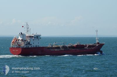
BOMAR VENUS
Oil/Chemical Tanker
Current Trip
| Time Travelled | 7 h, 44 mins |
|---|---|
| Remaining Time | 3 days |
| Distance Travelled | 86.14 nm |
| Remaining Distance | 1135.24 nm |
| AVG Speed | 11.5 Knots |
| MAX Speed | 12.3 Knots |
| AVG Wind | 16.1 knots |
| MAX Wind | 19.9 knots |
| MIN Temp | 20.3°C / 68.54°F |
| MAX Temp | 21.2°C / 70.16°F |
| Draught | 6.7 m |
| Position Received | Now |
Current Position
| Longitude | -6.15238° |
|---|---|
| Latitude | 35.88859° |
| Status | Under way using engine |
| Speed | 12.4 Knots |
| Course | 90.3° |
| Area | North Atlantic Ocean |
| Station | T-AIS |
| Position Received | Now |
Info
Information
The current position of BOMAR VENUS is in North Atlantic Ocean with coordinates 35.88859° / -6.15238° as reported on 2024-06-15 22:08 by AIS to our vessel tracker app. The vessel's current speed is 12.4 Knots and is heading at the port of AUGUSTA. The estimated time of arrival as calculated by vessel tracking app is 2024-06-19 21:02 LT
The vessel BOMAR VENUS (IMO: 9374014, MMSI: 215135000) is a Oil/Chemical Tanker that was built in 2006 ( 18 years old ). It's sailing under the flag of [MT] Malta.
In this page you can find informations about the vessels current position, last detected port calls, and current voyage information. If the vessels is not in coverage by AIS you will find the latest position.
The current position of BOMAR VENUS is detected by our AIS receivers and we are not responsible for the reliability of the data. The last position was recorded while the vessel was in Coverage by the Ais receivers of our vessel tracking app.
The current draught of BOMAR VENUS as reported by AIS is 6.7 meters
Weather
| Temperature | 20.3°C / 68.54°F |
|---|---|
| Wind Speed | 12 knots |
| Direction | 235° SW |
| Pressure | 1016.5 hPa |
| Humidity | 75.2 % |
| Cloud Coverage | --- |
Featured Company
Last Port Calls
| Port | Arrival | Departure | Time In Port |
|---|---|---|---|
| 2024-06-14 21:06 | 2024-06-15 14:25 | 17 h | |
| 2024-06-13 13:31 | 2024-06-13 16:43 | 3 h | |
| 2024-06-11 16:19 | 2024-06-12 17:15 | 1 d | |
| 2024-06-09 00:11 | 2024-06-10 01:26 | 1 d | |
| 2024-06-06 03:20 | 2024-06-07 03:57 | 1 d | |
| 2024-06-02 11:56 | 2024-06-02 16:44 | 4 h | |
| 2024-05-28 19:53 | 2024-05-29 18:50 | 22 h | |
| 2024-05-25 20:15 | 2024-05-26 15:24 | 19 h | |
| 2024-05-23 22:15 | 2024-05-24 17:30 | 19 h | |
| 2024-05-21 00:31 | 2024-05-21 15:00 | 14 h |
Last Trips
| Origin | Departure | Destination | Arrival | Distance | |
|---|---|---|---|---|---|
| 2024-06-13 18:43 | 2024-06-14 23:06 | 223.25 nm | |||
| 2024-06-12 19:15 | 2024-06-13 15:31 | 113.87 nm | |||
| 2024-06-10 03:26 | 2024-06-11 18:19 | 430.92 nm | |||
| 2024-06-07 05:57 | 2024-06-09 02:11 | 372.94 nm | |||
| 2024-06-02 18:44 | 2024-06-06 05:20 | 877.18 nm | |||
| 2024-05-29 20:50 | 2024-06-02 13:56 | 953.84 nm | |||
| 2024-05-26 17:24 | 2024-05-28 21:53 | 287.62 nm | |||
| 2024-05-24 19:30 | 2024-05-25 22:15 | 279.69 nm | |||
| 2024-05-21 16:00 | 2024-05-24 00:15 | 649.21 nm | |||
| 2024-05-19 06:44 | 2024-05-21 01:31 | 179.55 nm |
Events
| Time | Event | Details | Position / Dest | Info |
|---|---|---|---|---|
| 2024-06-15 22:08 | Status Changed | Under way using engine Default |
35.88861 / -6.15450
ITAUG
|
Speed: 12.3 kn Course: 91° |
| 2024-06-15 22:07 | Status Changed | Default Under way using engine |
35.88865 / -6.15875
ITAUG
|
Speed: 12.4 kn Course: 88.8° |
| 2024-06-15 21:45 | Status Changed | Under way using engine Default |
35.88984 / -6.25175
ITAUG
|
Speed: 12.2 kn Course: 81° |
| 2024-06-15 21:35 | Status Changed | Default Under way using engine |
35.88680 / -6.29190
ITAUG
|
Speed: 12 kn Course: 92.5° |
| 2024-06-15 21:14 | Change Sea Area | Moroccan part of the North Atlantic Ocean Spanish part of the North Atlantic Ocean |
35.91809 / -6.36009
North Atlantic Ocean
ITAUG
|
Speed: 12 kn Course: 145.9° |
| 2024-06-15 19:15 | Status Changed | Under way using engine Default |
36.25777 / -6.61921
ITAUG
|
Speed: 12 kn Course: 146° |
| 2024-06-15 18:52 | Status Changed | Default Under way using engine |
36.32203 / -6.67288
ITAUG
|
Speed: 11.9 kn Course: 146.9° |
| 2024-06-15 14:25 | PORT DEPARTURE |
|
37.12246 / -6.83484
ITAUG
|
Speed: 7.8 kn Course: 157° |
| 2024-06-15 14:04 | START Moving |
37.15682 / -6.89563
[ES] HUELVA
|
Speed: 3.3 kn Course: 127° |
|
| 2024-06-15 13:52 | Status Changed | Under way using engine Moored |
37.15783 / -6.89340
[ES] HUELVA
|
Speed: Course: 307° |