
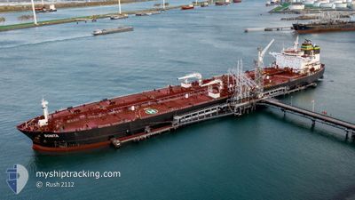
BONITA
Crude Oil Tanker
Current Trip
| Time Travelled | 32 days |
|---|---|
| Remaining Time | --- |
| Distance Travelled | 8737.24 nm |
| Remaining Distance | --- |
| AVG Speed | 12.6 Knots |
| MAX Speed | 16.7 Knots |
| AVG Wind | 12.8 knots |
| MAX Wind | 35 knots |
| MIN Temp | 9.8°C / 49.64°F |
| MAX Temp | 29.3°C / 84.74°F |
| Draught | 8.2 m |
| Position Received | 6 d ago |
Current Position
| Longitude | -63.41971° |
|---|---|
| Latitude | 17.17182° |
| Status | Under way using engine |
| Speed | 12.5 Knots |
| Course | 247.2° |
| Area | Caribbean Sea |
| Station | T-AIS |
| Position Received | 6 d ago |
Info
Information
The current position of BONITA is in Caribbean Sea with coordinates 17.17182° / -63.41971° as reported on 2024-06-19 13:05 by AIS to our vessel tracker app. The vessel's current speed is 12.5 Knots
The vessel BONITA (IMO: 9297541, MMSI: 538009978) is a Crude Oil Tanker that was built in 2006 ( 18 years old ). It's sailing under the flag of [MH] Marshall Is.
In this page you can find informations about the vessels current position, last detected port calls, and current voyage information. If the vessels is not in coverage by AIS you will find the latest position.
The current position of BONITA is detected by our AIS receivers and we are not responsible for the reliability of the data. The last position was recorded while the vessel was in Coverage by the Ais receivers of our vessel tracking app.
The current draught of BONITA as reported by AIS is 8.2 meters
Weather
| Temperature | 27.7°C / 81.86°F |
|---|---|
| Wind Speed | 4 knots |
| Direction | 48° NE |
| Pressure | 1012.9 hPa |
| Humidity | 80 % |
| Cloud Coverage | 68 % |
Featured Company
Most Visited Ports (Last year)
| Port | Arrivals | |
|---|---|---|
| 3 | ||
| 3 | ||
| 2 | ||
| 2 | ||
| 2 | ||
| 1 |
Last Trips
| Origin | Departure | Destination | Arrival | Distance | |
|---|---|---|---|---|---|
| 2024-05-09 19:00 | 2024-05-23 02:56 | 584.33 nm | |||
| 2024-03-31 02:40 | 2024-05-08 12:48 | 8387.47 nm |
Events
| Time | Event | Details | Position / Dest | Info |
|---|---|---|---|---|
| 2024-06-25 17:59 | STOP Moving | 7.24 nm, North of COATZACOALCOS |
18.26887 / -94.40374
MX COA
|
Speed: 0.2 kn Course: 285° |
| 2024-06-19 13:35 | Status Changed | Default Under way using engine |
17.13352 / -63.52262
MX COA
|
Speed: 12.5 kn Course: 247.2° |
| 2024-06-19 13:05 | OUT of Coverage |
17.17182 / -63.41971
Caribbean Sea
MX COA
|
Speed: 12.5 kn Course: 247.2° |
|
| 2024-06-19 12:58 | Detected in Sea | Saba part of the Caribbean Sea |
17.17960 / -63.39990
Caribbean Sea
MX COA
|
Speed: 12.6 kn Course: 247.9° |
| 2024-06-19 12:58 | Status Changed | Under way using engine Default |
17.17960 / -63.39990
MX COA
|
Speed: 12.7 kn Course: 248° |
| 2024-06-19 12:55 | IN Coverage |
17.17960 / -63.39990
Caribbean Sea
MX COA
|
Speed: 12.6 kn Course: 247.9° |
|
| 2024-06-19 11:15 | Status Changed | Default Under way using engine |
17.39019 / -63.09003
MX COA
|
Speed: 13.1 kn Course: 220.2° |
| 2024-06-19 11:10 | OUT of Coverage |
17.40452 / -63.07705
Caribbean Sea
MX COA
|
Speed: 13.1 kn Course: 220.2° |
|
| 2024-06-19 11:05 | Status Changed | Under way using engine Default |
17.41784 / -63.06567
MX COA
|
Speed: 13 kn Course: 220° |
| 2024-06-19 09:55 | OUT of Coverage |
17.48325 / -63.01088
Caribbean Sea
MX COA
|
Speed: 0.3 kn Course: 238.1° |