
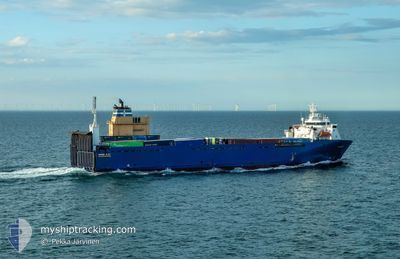
BORE BAY
Vehicles Carrier
Current Trip
| Time Travelled | 6 h, 18 mins |
|---|---|
| Remaining Time | 1 day |
| Distance Travelled | 67.92 nm |
| Remaining Distance | 325.37 nm |
| AVG Speed | 11 Knots |
| MAX Speed | 13.4 Knots |
| AVG Wind | 4.5 knots |
| MAX Wind | 9 knots |
| MIN Temp | 11.9°C / 53.42°F |
| MAX Temp | 14.4°C / 57.92°F |
| Draught | 5.8 m |
| Position Received | 1 h, 47 m ago |
Current Position
| Longitude | 3.22972° |
|---|---|
| Latitude | 52.28920° |
| Status | Under way using engine |
| Speed | 12.7 Knots |
| Course | 297.1° |
| Area | North Sea |
| Station | T-AIS |
| Position Received | 1 h, 47 m ago |
Info
Information
The current position of BORE BAY is in North Sea with coordinates 52.28920° / 3.22972° as reported on 2024-05-24 01:56 by AIS to our vessel tracker app. The vessel's current speed is 12.7 Knots and is heading at the port of ABERDEEN. The estimated time of arrival as calculated by vessel tracking app is 2024-05-25 04:38 LT
The vessel BORE BAY (IMO: 9122007, MMSI: 230357000) is a Vehicles Carrier that was built in 1997 ( 27 years old ). It's sailing under the flag of [FI] Finland.
In this page you can find informations about the vessels current position, last detected port calls, and current voyage information. If the vessels is not in coverage by AIS you will find the latest position.
The current position of BORE BAY is detected by our AIS receivers and we are not responsible for the reliability of the data. The last position was recorded while the vessel was in Coverage by the Ais receivers of our vessel tracking app.
The current draught of BORE BAY as reported by AIS is 5.8 meters
Weather
| Temperature | 12°C / 53.6°F |
|---|---|
| Wind Speed | 8 knots |
| Direction | 250° WSW |
| Pressure | 1016.8 hPa |
| Humidity | 81.6 % |
| Cloud Coverage | 3 % |
Featured Company
Last Port Calls
| Port | Arrival | Departure | Time In Port |
|---|---|---|---|
| 2024-05-23 17:21 | 2024-05-23 21:25 | 4 h | |
| 2024-05-22 15:05 | 2024-05-22 19:56 | 4 h | |
| 2024-05-21 17:31 | 2024-05-21 20:15 | 2 h | |
| 2024-05-21 05:40 | 2024-05-21 15:36 | 9 h | |
| 2024-05-20 21:27 | 2024-05-21 05:26 | 7 h | |
| 2024-05-20 13:31 | 2024-05-20 18:15 | 4 h | |
| 2024-05-20 05:50 | 2024-05-20 09:36 | 3 h | |
| 2024-05-19 23:35 | 2024-05-20 00:23 | 48 m | |
| 2024-05-19 16:36 | 2024-05-19 21:31 | 4 h | |
| 2024-05-17 13:09 | 2024-05-18 13:26 | 1 d |
Last Trips
| Origin | Departure | Destination | Arrival | Distance | |
|---|---|---|---|---|---|
| 2024-05-22 21:56 | 2024-05-23 19:21 | 308.58 nm | |||
| 2024-05-21 22:15 | 2024-05-22 17:05 | 263.21 nm | |||
| 2024-05-21 17:36 | 2024-05-21 19:31 | 26.26 nm | |||
| 2024-05-21 07:26 | 2024-05-21 07:40 | 1.23 nm | |||
| 2024-05-20 20:15 | 2024-05-20 23:27 | 41.23 nm | |||
| 2024-05-20 11:36 | 2024-05-20 15:31 | 51.05 nm | |||
| 2024-05-20 02:23 | 2024-05-20 07:50 | 76.88 nm | |||
| 2024-05-19 23:31 | 2024-05-20 01:35 | 27.35 nm | |||
| 2024-05-18 14:26 | 2024-05-19 18:36 | 387.26 nm | |||
| 2024-05-17 00:09 | 2024-05-17 14:09 | 201.01 nm |
Events
| Time | Event | Details | Position / Dest | Info |
|---|---|---|---|---|
| 2024-05-24 02:08 | Status Changed | Default Under way using engine |
52.32153 / 3.12877
GBABD
|
Speed: 12.7 kn Course: 297.1° |
| 2024-05-24 01:56 | Status Changed | Under way using engine Default |
52.28920 / 3.22972
GBABD
|
Speed: 13 kn Course: 297° |
| 2024-05-24 01:56 | OUT of Coverage |
52.28920 / 3.22972
North Sea
GBABD
|
Speed: 12.7 kn Course: 297.1° |
|
| 2024-05-24 01:40 | Status Changed | Default Under way using engine |
52.27500 / 3.27333
GBABD
|
Speed: 12.6 kn Course: 296.2° |
| 2024-05-24 01:29 | Status Changed | Under way using engine Default |
52.25861 / 3.32770
GBABD
|
Speed: 12.3 kn Course: 296° |
| 2024-05-24 01:16 | Status Changed | Default Under way using engine |
52.23667 / 3.39333
GBABD
|
Speed: 13.1 kn Course: 317.7° |
| 2024-05-23 21:25 | PORT DEPARTURE |
|
51.89430 / 4.39782
GBABD
|
Speed: 5.8 kn Course: 315° |
| 2024-05-23 21:17 | START Moving |
51.88406 / 4.40720
[NL] ROTTERDAM PERNIS
|
Speed: 3.4 kn Course: 340° |
|
| 2024-05-23 20:36 | Draught Changed | 5.8 6.6 |
51.88250 / 4.40628
[NL] ROTTERDAM PERNIS
|
Speed: Course: 173° |
| 2024-05-23 20:36 | Destination Changed | GBABD NLRTM |
51.88250 / 4.40628
[NL] ROTTERDAM PERNIS
|
Speed: Course: 173° |