
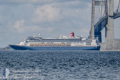
BOREALIS
Passengers Ship
Current Trip
| Time Travelled | 1 day |
|---|---|
| Remaining Time | 8 h, 30 mins |
| Distance Travelled | 710.26 nm |
| Remaining Distance | 186.17 nm |
| AVG Speed | 15.5 Knots |
| MAX Speed | 21.1 Knots |
| AVG Wind | 10.8 knots |
| MAX Wind | 21.7 knots |
| MIN Temp | 14.9°C / 58.82°F |
| MAX Temp | 21.6°C / 70.88°F |
| Draught | 8.4 m |
| Position Received | 1 m ago |
Current Position
| Longitude | -4.84929° |
|---|---|
| Latitude | 49.04604° |
| Status | Under way using engine |
| Speed | 16.6 Knots |
| Course | 60.8° |
| Area | English Channel |
| Station | T-AIS |
| Position Received | 1 m ago |
Info
Information
The current position of BOREALIS is in English Channel with coordinates 49.04604° / -4.84929° as reported on 2024-06-18 13:30 by AIS to our vessel tracker app. The vessel's current speed is 16.6 Knots and is heading at the port of SOUTHAMPTON. The estimated time of arrival as calculated by vessel tracking app is 2024-06-18 22:01 LT
The vessel BOREALIS (IMO: 9122552, MMSI: 311000987) is a Passengers Ship that was built in 1997 ( 27 years old ). It's sailing under the flag of [BS] Bahamas.
In this page you can find informations about the vessels current position, last detected port calls, and current voyage information. If the vessels is not in coverage by AIS you will find the latest position.
The current position of BOREALIS is detected by our AIS receivers and we are not responsible for the reliability of the data. The last position was recorded while the vessel was in Coverage by the Ais receivers of our vessel tracking app.
The current draught of BOREALIS as reported by AIS is 8.4 meters
Weather
| Temperature | 15°C / 59°F |
|---|---|
| Wind Speed | 13 knots |
| Direction | 31° NNE |
| Pressure | 1015.1 hPa |
| Humidity | 90.4 % |
| Cloud Coverage | 99 % |
Featured Company
Last Port Calls
| Port | Arrival | Departure | Time In Port |
|---|---|---|---|
| 2024-06-16 06:50 | 2024-06-16 17:04 | 10 h | |
| 2024-06-14 06:31 | 2024-06-14 16:31 | 10 h | |
| 2024-06-12 06:25 | 2024-06-12 16:55 | 10 h | |
| 2024-06-10 04:46 | 2024-06-10 14:18 | 9 h | |
| 2024-06-08 04:57 | 2024-06-08 16:09 | 11 h | |
| 2024-06-06 06:23 | 2024-06-06 18:35 | 12 h | |
| 2024-06-03 05:26 | 2024-06-03 16:12 | 10 h | |
| 2024-05-30 04:35 | 2024-05-30 17:24 | 12 h | |
| 2024-05-29 04:08 | 2024-05-29 15:13 | 11 h | |
| 2024-05-25 04:29 | 2024-05-25 17:53 | 13 h |
Last Trips
| Origin | Departure | Destination | Arrival | Distance | |
|---|---|---|---|---|---|
| 2024-06-14 18:31 | 2024-06-16 07:50 | 569.48 nm | |||
| 2024-06-12 17:55 | 2024-06-14 08:31 | 607.39 nm | |||
| 2024-06-10 16:18 | 2024-06-12 07:25 | 703.21 nm | |||
| 2024-06-08 18:09 | 2024-06-10 06:46 | 379.66 nm | |||
| 2024-06-06 20:35 | 2024-06-08 06:57 | 489.42 nm | |||
| 2024-06-03 18:12 | 2024-06-06 08:23 | 1014.06 nm | |||
| 2024-05-30 18:24 | 2024-06-03 07:26 | 1242.41 nm | |||
| 2024-05-29 17:13 | 2024-05-30 05:35 | 140.17 nm | |||
| 2024-05-25 18:53 | 2024-05-29 06:08 | 610.89 nm | |||
| 2024-05-21 15:22 | 2024-05-25 05:29 | 1231.70 nm |
Events
| Time | Event | Details | Position / Dest | Info |
|---|---|---|---|---|
| 2024-06-18 13:25 | Change Sea Area | French part of the English Channel French part of the Celtic Sea |
49.03534 / -4.87876
English Channel
GB SOU
|
Speed: 16.5 kn Course: 60.8° |
| 2024-06-18 13:07 | Status Changed | Under way using engine Default |
48.99379 / -4.98801
GB SOU
|
Speed: 16.5 kn Course: 59° |
| 2024-06-18 13:03 | Status Changed | Default Under way using engine |
48.98532 / -5.00943
GB SOU
|
Speed: 16.6 kn Course: 62.2° |
| 2024-06-18 12:48 | Status Changed | Under way using engine Default |
48.95162 / -5.10496
GB SOU
|
Speed: 17.2 kn Course: 62° |
| 2024-06-18 12:47 | Status Changed | Default Under way using engine |
48.95045 / -5.10822
GB SOU
|
Speed: 20.5 kn Course: 61.7° |
| 2024-06-18 12:42 | Status Changed | Under way using engine Default |
48.93734 / -5.14518
GB SOU
|
Speed: 21.1 kn Course: 62° |
| 2024-06-18 12:35 | Status Changed | Default Under way using engine |
48.91920 / -5.19714
GB SOU
|
Speed: 21.1 kn Course: 62° |
| 2024-06-18 12:35 | Status Changed | Under way using engine Default |
48.91837 / -5.19954
GB SOU
|
Speed: 21 kn Course: 62° |
| 2024-06-18 12:19 | IN Coverage |
48.91837 / -5.19954
Celtic Sea
GB SOU
|
Speed: 21.1 kn Course: 62° |
|
| 2024-06-18 11:21 | OUT of Coverage |
48.71697 / -5.62898
Celtic Sea
GB SOU
|
Speed: 16.5 kn Course: 30.8° |