
BRISANI
Other Type
Current Trip
| Time Travelled | 17 h, 23 mins |
|---|---|
| Remaining Time | --- |
| Distance Travelled | 26.34 nm |
| Remaining Distance | --- |
| AVG Speed | 6.2 Knots |
| MAX Speed | 8.6 Knots |
| AVG Wind | 11.5 knots |
| MAX Wind | 15 knots |
| MIN Temp | 12.7°C / 54.86°F |
| MAX Temp | 16.7°C / 62.06°F |
| Draught | 3.2 m |
| Position Received | 2 m ago |
Current Position
| Longitude | 5.68755° |
|---|---|
| Latitude | 51.89180° |
| Status | Moored |
| Speed | |
| Course | 309° |
| Area | North Sea |
| Station | T-AIS |
| Position Received | 2 m ago |
Info
Information
The current position of BRISANI is in North Sea with coordinates 51.89180° / 5.68755° as reported on 2024-05-29 06:36 by AIS to our vessel tracker app. The vessel's current speed is 0 Knots
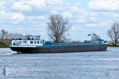
The vessel BRISANI (MMSI: 244002007) is a Other Type It's sailing under the flag of [NL] Netherlands.
In this page you can find informations about the vessels current position, last detected port calls, and current voyage information. If the vessels is not in coverage by AIS you will find the latest position.
The current position of BRISANI is detected by our AIS receivers and we are not responsible for the reliability of the data. The last position was recorded while the vessel was in Coverage by the Ais receivers of our vessel tracking app.
The current draught of BRISANI as reported by AIS is 3.2 meters
Weather
| Temperature | 14.1°C / 57.38°F |
|---|---|
| Wind Speed | 12 knots |
| Direction | 227° SW |
| Pressure | 1008.4 hPa |
| Humidity | 93.4 % |
| Cloud Coverage | 100 % |
Featured Company
Last Port Calls
| Port | Arrival | Departure | Time In Port |
|---|---|---|---|
| 2024-05-27 20:34 | 2024-05-28 13:15 | 16 h | |
| 2024-05-24 13:56 | 2024-05-27 07:24 | 2 d | |
| 2024-05-21 04:55 | |||
| 2024-05-20 20:19 | |||
| 2024-05-20 20:19 | |||
| 2024-05-17 17:11 | |||
| 2024-05-16 11:51 | 2024-05-16 12:08 | 16 m | |
| 2024-05-15 15:40 | 2024-05-16 11:18 | 19 h | |
| 2024-05-15 13:55 | 2024-05-15 14:29 | 34 m | |
| 2024-05-14 08:15 | 2024-05-14 16:56 | 8 h |
Last Trips
| Origin | Departure | Destination | Arrival | Distance | |
|---|---|---|---|---|---|
| 2024-05-27 09:24 | 2024-05-27 22:34 | 61.38 nm | |||
| 2024-05-21 06:55 | 2024-05-24 15:56 | 25.07 nm | |||
| 2024-05-20 22:19 | 2024-05-20 22:19 | 0.07 nm | |||
| 2024-05-16 14:08 | 2024-05-17 19:11 | 109.07 nm | |||
| 2024-05-16 13:18 | 2024-05-16 13:51 | 3.27 nm | |||
| 2024-05-15 16:29 | 2024-05-15 17:40 | 2.82 nm | |||
| 2024-05-14 18:56 | 2024-05-15 15:55 | 63.10 nm | |||
| 2024-05-13 11:35 | 2024-05-14 10:15 | 69.56 nm | |||
| 2024-05-09 07:41 | 2024-05-09 14:42 | 33.85 nm | |||
| 2024-05-08 20:49 | 2024-05-09 06:43 | 12.13 nm |
Events
| Time | Event | Details | Position / Dest | Info |
|---|---|---|---|---|
| 2024-05-28 20:10 | Destination Changed | BERGEN OP ZOOM THE DEEST |
51.89138 / 5.68930
BERGEN OP ZOOM THE
|
Speed: Course: 307° |
| 2024-05-28 20:10 | ETA Changed | 2024/05/29 18:01 2024/05/28 13:45 |
51.89138 / 5.68930
BERGEN OP ZOOM THE
|
Speed: Course: 307° |
| 2024-05-28 18:30 | Status Changed | Moored Under way using engine |
51.89137 / 5.68928
DEEST
|
Speed: Course: 307° |
| 2024-05-28 18:08 | STOP Moving | 0.62 nm, East of DEEST |
51.89201 / 5.68872
DEEST
|
Speed: 0.3 kn Course: 280° |
| 2024-05-28 16:33 | START Moving | 0.89 nm, North East of TIEL |
51.89937 / 5.45587
DEEST
|
Speed: 7 kn Course: 161° |
| 2024-05-28 16:14 | STOP Moving | 0.97 nm, North East of TIEL |
51.90134 / 5.45466
DEEST
|
Speed: Course: 158° |
| 2024-05-28 16:09 | START Moving | 1.16 nm, North of TIEL |
51.90534 / 5.45231
DEEST
|
Speed: 4.5 kn Course: 160° |
| 2024-05-28 15:55 | STOP Moving | 1.26 nm, North of TIEL |
51.90724 / 5.45172
DEEST
|
Speed: 0.3 kn Course: 158° |
| 2024-05-28 13:15 | PORT DEPARTURE |
|
52.05798 / 5.09967
DEEST
|
Speed: 8.6 kn Course: 152.2° |
| 2024-05-28 13:06 | START Moving |
52.07482 / 5.08371
[NL] UTRECHT
|
Speed: 4.8 kn Course: 135.3° |