
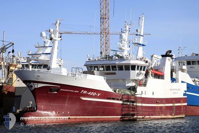
BRUSOEYSKJAER
Trawler
Current Trip
Unknown
| Time Travelled | 2 days |
|---|---|
| Remaining Time | --- |
| Distance Travelled | 206.52 nm |
| Remaining Distance | --- |
| AVG Speed | 6.8 Knots |
| MAX Speed | 11.7 Knots |
| AVG Wind | 17.1 knots |
| MAX Wind | 24.7 knots |
| MIN Temp | 9.4°C / 48.92°F |
| MAX Temp | 11.7°C / 53.06°F |
| Draught | 0 m |
| Position Received | 4 h, 23 m ago |
Current Position
| Longitude | 2.93532° |
|---|---|
| Latitude | 60.28382° |
| Status | Under way using engine |
| Speed | 11.2 Knots |
| Course | 331.9° |
| Area | North Sea |
| Station | T-AIS |
| Position Received | 4 h, 23 m ago |
Info
Information
The current position of BRUSOEYSKJAER is in North Sea with coordinates 60.28382° / 2.93532° as reported on 2024-06-06 15:43 by AIS to our vessel tracker app. The vessel's current speed is 11.2 Knots
The vessel BRUSOEYSKJAER (IMO: 9281994, MMSI: 257404000) is a Trawler that was built in 2004 ( 20 years old ). It's sailing under the flag of [NO] Norway.
In this page you can find informations about the vessels current position, last detected port calls, and current voyage information. If the vessels is not in coverage by AIS you will find the latest position.
The current position of BRUSOEYSKJAER is detected by our AIS receivers and we are not responsible for the reliability of the data. The last position was recorded while the vessel was in Coverage by the Ais receivers of our vessel tracking app.
Weather
| Temperature | 10.1°C / 50.18°F |
|---|---|
| Wind Speed | 18 knots |
| Direction | 231° SW |
| Pressure | 1007.1 hPa |
| Humidity | 62.9 % |
| Cloud Coverage | 77 % |
Featured Company
Last Port Calls
| Port | Arrival | Departure | Time In Port |
|---|---|---|---|
| 2024-06-03 23:53 | 2024-06-04 15:45 | 15 h | |
| 2024-06-03 21:34 | 2024-06-03 23:16 | 1 h | |
| 2024-06-02 09:08 | 2024-06-03 20:58 | 1 d | |
| 2024-06-02 04:37 | 2024-06-02 06:43 | 2 h | |
| 2024-05-27 01:59 | 2024-05-27 17:14 | 15 h | |
| 2024-05-22 18:08 | 2024-05-22 22:54 | 4 h | |
| 2024-05-22 16:06 | 2024-05-22 16:21 | 14 m | |
| 2024-05-21 15:04 |
Last Trips
| Origin | Departure | Destination | Arrival | Distance | |
|---|---|---|---|---|---|
| 2024-06-04 01:16 | 2024-06-04 01:53 | 4.34 nm | |||
| 2024-06-03 22:58 | 2024-06-03 23:34 | 4.85 nm | |||
| 2024-06-02 08:43 | 2024-06-02 11:08 | 18.33 nm | |||
| 2024-05-27 19:14 | 2024-06-02 06:37 | 696.04 nm | |||
| 2024-05-23 00:54 | 2024-05-27 03:59 | 538.11 nm | |||
| 2024-05-22 18:21 | 2024-05-22 20:08 | 16.90 nm | |||
| 2024-05-21 17:04 | 2024-05-22 18:06 | 212.87 nm |
Events
| Time | Event | Details | Position / Dest | Info |
|---|---|---|---|---|
| 2024-06-06 15:43 | OUT of Coverage |
60.28382 / 2.93532
North Sea
|
Speed: 11.2 kn Course: 331.9° |
|
| 2024-06-06 15:19 | IN Coverage |
60.23165 / 2.83790
North Sea
|
Speed: 11.1 kn Course: 41.7° |
|
| 2024-06-06 13:53 | OUT of Coverage |
60.05113 / 3.01770
North Sea
|
Speed: 10.4 kn Course: 282.6° |
|
| 2024-06-06 12:27 | IN Coverage |
59.82102 / 3.00563
North Sea
|
Speed: 11.7 kn Course: 25.5° |
|
| 2024-06-06 05:49 | OUT of Coverage |
59.36337 / 3.04773
North Sea
|
Speed: 8.9 kn Course: 55.9° |
|
| 2024-06-06 05:49 | IN Coverage |
59.36337 / 3.04773
North Sea
|
Speed: 8.9 kn Course: 55.9° |
|
| 2024-06-05 20:04 | OUT of Coverage |
59.20027 / 3.15155
North Sea
|
Speed: 3.6 kn Course: 179° |
|
| 2024-06-05 19:48 | IN Coverage |
59.20443 / 3.14503
North Sea
|
Speed: 2.4 kn Course: 51.8° |
|
| 2024-06-05 18:19 | OUT of Coverage |
59.20778 / 3.09802
North Sea
|
Speed: 0.7 kn Course: 72.6° |
|
| 2024-06-05 17:27 | IN Coverage |
59.20403 / 3.04662
North Sea
|
Speed: 3.7 kn Course: 64.2° |