
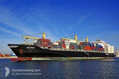
CALANDRA
Container Ship
Current Trip
BRSNT
| Time Travelled | 10 days |
|---|---|
| Remaining Time | --- |
| Distance Travelled | 873.16 nm |
| Remaining Distance | --- |
| AVG Speed | 15.2 Knots |
| MAX Speed | 16.8 Knots |
| AVG Wind | 7.3 knots |
| MAX Wind | 23 knots |
| MIN Temp | 11.2°C / 52.16°F |
| MAX Temp | 21°C / 69.8°F |
| Draught | 9.4 m |
| Position Received | 9 h, 25 m ago |
Current Position
| Longitude | -47.78580° |
|---|---|
| Latitude | -26.65341° |
| Status | Under way using engine |
| Speed | 16.4 Knots |
| Course | 19.3° |
| Area | South Atlantic Ocean |
| Station | T-AIS |
| Position Received | 9 h, 25 m ago |
Info
Information
The current position of CALANDRA is in South Atlantic Ocean with coordinates -26.65341° / -47.78580° as reported on 2024-06-20 18:06 by AIS to our vessel tracker app. The vessel's current speed is 16.4 Knots
The vessel CALANDRA (IMO: 9445887, MMSI: 305538000) is a Container Ship that was built in 2010 ( 14 years old ). It's sailing under the flag of [AG] Antigua Barbuda.
In this page you can find informations about the vessels current position, last detected port calls, and current voyage information. If the vessels is not in coverage by AIS you will find the latest position.
The current position of CALANDRA is detected by our AIS receivers and we are not responsible for the reliability of the data. The last position was recorded while the vessel was in Coverage by the Ais receivers of our vessel tracking app.
The current draught of CALANDRA as reported by AIS is 9.4 meters
Weather
| Temperature | 21°C / 69.8°F |
|---|---|
| Wind Speed | 2 knots |
| Direction | 226° SW |
| Pressure | 1019.6 hPa |
| Humidity | 85.5 % |
| Cloud Coverage | 22 % |
Featured Company
Last Port Calls
| Port | Arrival | Departure | Time In Port |
|---|---|---|---|
| 2024-06-10 00:06 | 2024-06-10 15:06 | 14 h | |
| 2024-06-07 11:10 | 2024-06-08 23:21 | 1 d | |
| 2024-05-23 00:04 | 2024-05-23 09:26 | 9 h | |
| 2024-05-20 06:54 | 2024-05-21 09:42 | 1 d | |
| 2024-05-16 09:38 | 2024-05-16 22:50 | 13 h | |
| 2024-05-13 14:21 | 2024-05-14 06:55 | 16 h | |
| 2024-05-11 17:34 | 2024-05-12 02:29 | 8 h | |
| 2024-05-09 20:46 | 2024-05-11 01:22 | 1 d | |
| 2024-05-05 21:11 | 2024-05-06 13:10 | 15 h | |
| 2024-04-24 11:45 | 2024-04-24 11:51 | 5 m |
Most Visited Ports (Last year)
| Port | Arrivals | |
|---|---|---|
| 7 | ||
| 4 | ||
| 4 | ||
| 4 | ||
| 4 | ||
| 3 |
Last Trips
| Origin | Departure | Destination | Arrival | Distance | |
|---|---|---|---|---|---|
| 2024-06-08 20:21 | 2024-06-09 21:06 | 145.02 nm | |||
| 2024-05-23 04:26 | 2024-06-07 08:10 | 5177.07 nm | |||
| 2024-05-21 04:42 | 2024-05-22 19:04 | 496.86 nm | |||
| 2024-05-16 17:50 | 2024-05-20 01:54 | 1134.64 nm | |||
| 2024-05-14 01:55 | 2024-05-16 04:38 | 516.67 nm | |||
| 2024-05-11 21:29 | 2024-05-13 09:21 | 498.39 nm | |||
| 2024-05-10 20:22 | 2024-05-11 12:34 | 240.01 nm | |||
| 2024-05-06 08:10 | 2024-05-09 15:46 | 1215.39 nm | |||
| 2024-04-24 08:51 | 2024-05-05 16:11 | 4262.31 nm | |||
| 2024-04-23 04:56 | 2024-04-24 08:45 | 234.22 nm |
Events
| Time | Event | Details | Position / Dest | Info |
|---|---|---|---|---|
| 2024-06-20 18:14 | Status Changed | Default Under way using engine |
-26.62341 / -47.77112
BRSNT
|
Speed: 16.4 kn Course: 19.3° |
| 2024-06-20 18:06 | OUT of Coverage |
-26.65341 / -47.78580
South Atlantic Ocean
BRSNT
|
Speed: 16.4 kn Course: 19.3° |
|
| 2024-06-20 17:59 | Change Sea Area | Brazilian part of the South Atlantic Ocean Uruguayan part of the South Atlantic Ocean |
-26.68581 / -47.79878
South Atlantic Ocean
BRSNT
|
Speed: 16.1 kn Course: 20.3° |
| 2024-06-20 17:59 | Status Changed | Under way using engine Default |
-26.68668 / -47.79912
BRSNT
|
Speed: 16.2 kn Course: 20° |
| 2024-06-20 17:43 | IN Coverage |
-26.68581 / -47.79878
South Atlantic Ocean
BRSNT
|
Speed: 16.1 kn Course: 20.3° |
|
| 2024-06-19 01:30 | Status Changed | Default Under way using engine |
-35.08935 / -54.76033
BRSNT
|
Speed: 15.5 kn Course: 87.6° |
| 2024-06-19 01:22 | OUT of Coverage |
-35.09099 / -54.80096
South Atlantic Ocean
BRSNT
|
Speed: 15.5 kn Course: 87.6° |
|
| 2024-06-19 00:25 | Detected in Sea | Uruguayan part of the South Atlantic Ocean |
-35.06321 / -55.09539
South Atlantic Ocean
BRSNT
|
Speed: 15.5 kn Course: 99.1° |
| 2024-06-18 23:31 | Destination Changed | BRSNT BRIIP |
-35.04983 / -55.37775
BRSNT
|
Speed: 15.6 kn Course: 88.1° |
| 2024-06-18 23:31 | ETA Changed | 2024/06/21 04:00 2024/06/17 15:00 |
-35.04983 / -55.37775
BRSNT
|
Speed: 15.6 kn Course: 88.1° |