
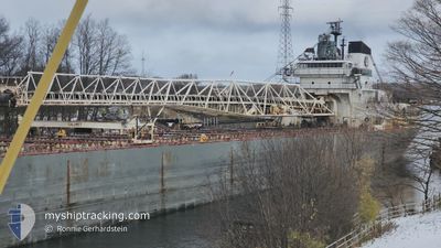
CALUMET
Self Discharging Bulk Carrier
Current Trip
| Time Travelled | 8 h, 28 mins |
|---|---|
| Remaining Time | --- |
| Distance Travelled | 84.63 nm |
| Remaining Distance | --- |
| AVG Speed | 8.9 Knots |
| MAX Speed | 12.3 Knots |
| AVG Wind | 3 knots |
| MAX Wind | 8 knots |
| MIN Temp | 9.2°C / 48.56°F |
| MAX Temp | 18.6°C / 65.48°F |
| Draught | 5.8 m |
| Position Received | 2 h, 48 m ago |
Current Position
| Longitude | -82.41613° |
|---|---|
| Latitude | 43.02040° |
| Status | Under way using engine |
| Speed | 10.6 Knots |
| Course | 1.9° |
| Area | --- |
| Station | T-AIS |
| Position Received | 2 h, 48 m ago |
Info
Information
The current position of CALUMET is in --- with coordinates 43.02040° / -82.41613° as reported on 2024-05-03 19:48 by AIS to our vessel tracker app. The vessel's current speed is 10.6 Knots
The vessel CALUMET (IMO: 7329314, MMSI: 367340990) is a Self Discharging Bulk Carrier that was built in 1973 ( 51 years old ). It's sailing under the flag of [US] USA.
In this page you can find informations about the vessels current position, last detected port calls, and current voyage information. If the vessels is not in coverage by AIS you will find the latest position.
The current position of CALUMET is detected by our AIS receivers and we are not responsible for the reliability of the data. The last position was recorded while the vessel was in Coverage by the Ais receivers of our vessel tracking app.
The current draught of CALUMET as reported by AIS is 5.8 meters
Weather
| Temperature | 9.3°C / 48.74°F |
|---|---|
| Wind Speed | 3 knots |
| Direction | 349° N |
| Pressure | 1016.6 hPa |
| Humidity | 95.4 % |
| Cloud Coverage | 100 % |
Featured Company
Last Port Calls
| Port | Arrival | Departure | Time In Port |
|---|---|---|---|
| 2024-05-03 13:18 | 2024-05-03 14:09 | 50 m | |
| 2024-05-03 03:02 | 2024-05-03 09:26 | 6 h | |
| 2024-05-01 21:15 | 2024-05-02 22:08 | 1 d | |
| 2024-04-29 03:06 | 2024-04-29 22:02 | 18 h | |
| 2024-04-28 12:44 | 2024-04-28 20:13 | 7 h | |
| 2024-04-25 00:50 | 2024-04-25 05:49 | 4 h | |
| 2024-04-24 13:02 | 2024-04-24 20:42 | 7 h | |
| 2024-04-23 06:26 | 2024-04-24 08:16 | 1 d | |
| 2024-04-22 12:18 | 2024-04-22 13:34 | 1 h | |
| 2024-04-21 17:43 | 2024-04-22 06:24 | 12 h |
Most Visited Ports (Last year)
| Port | Arrivals | |
|---|---|---|
| 47 | ||
| 21 | ||
| 13 | ||
| 13 | ||
| 12 | ||
| 7 |
Last Trips
| Origin | Departure | Destination | Arrival | Distance | |
|---|---|---|---|---|---|
| 2024-05-03 05:26 | 2024-05-03 09:18 | 41.43 nm | |||
| 2024-05-02 18:08 | 2024-05-02 23:02 | 43.90 nm | |||
| 2024-04-29 17:02 | 2024-05-01 17:15 | 560.39 nm | |||
| 2024-04-28 16:13 | 2024-04-28 22:06 | 40.61 nm | |||
| 2024-04-25 01:49 | 2024-04-28 08:44 | 541.87 nm | |||
| 2024-04-24 16:42 | 2024-04-24 20:50 | 41.14 nm | |||
| 2024-04-24 04:16 | 2024-04-24 09:02 | 41.86 nm | |||
| 2024-04-22 09:34 | 2024-04-23 02:26 | 93.18 nm | |||
| 2024-04-22 02:24 | 2024-04-22 08:18 | 46.86 nm | |||
| 2024-04-21 06:26 | 2024-04-21 13:43 | 47.25 nm |
Events
| Time | Event | Details | Position / Dest | Info |
|---|---|---|---|---|
| 2024-05-03 19:52 | Status Changed | Default Under way using engine |
43.03376 / -82.41550
STONEPORT
|
Speed: 10.6 kn Course: 1.9° |
| 2024-05-03 19:48 | OUT of Coverage |
43.02040 / -82.41613
STONEPORT
|
Speed: 10.6 kn Course: 1.9° |
|
| 2024-05-03 19:02 | Status Changed | Under way using engine Default |
42.93979 / -82.44424
STONEPORT
|
Speed: 4.5 kn Course: 32° |
| 2024-05-03 19:02 | IN Coverage |
42.94181 / -82.44138
STONEPORT
|
Speed: 5.8 kn Course: 43.4° |
|
| 2024-05-03 16:54 | Status Changed | Default Under way using engine |
42.63525 / -82.51215
STONEPORT
|
Speed: 9.9 kn Course: 12.2° |
| 2024-05-03 16:49 | OUT of Coverage |
42.62218 / -82.51664
STONEPORT
|
Speed: 9.9 kn Course: 12.2° |
|
| 2024-05-03 16:43 | Status Changed | Under way using engine Default |
42.60791 / -82.52342
STONEPORT
|
Speed: 9.9 kn Course: 48° |
| 2024-05-03 16:40 | Status Changed | Default Under way using engine |
42.60176 / -82.53278
STONEPORT
|
Speed: 10.2 kn Course: 37.9° |
| 2024-05-03 16:30 | ETA Changed | 2024/05/04 10:00 2024/05/04 08:00 |
42.58087 / -82.55946
STONEPORT
|
Speed: 10.1 kn Course: 46.4° |
| 2024-05-03 14:09 | PORT DEPARTURE |
|
42.33022 / -83.00074
STONEPORT
|
Speed: 10.2 kn Course: 86° |