
CAMILLA HOEJ
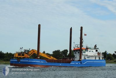
Dredger
Current Trip
| Time Travelled | 1 day |
|---|---|
| Remaining Time | --- |
| Distance Travelled | 107.99 nm |
| Remaining Distance | --- |
| AVG Speed | 7.5 Knots |
| MAX Speed | 9.1 Knots |
| AVG Wind | 10.4 knots |
| MAX Wind | 15 knots |
| MIN Temp | 11.2°C / 52.16°F |
| MAX Temp | 19.8°C / 67.64°F |
| Draught | 3 m |
| Position Received | Now |
Current Position
| Longitude | 10.39456° |
|---|---|
| Latitude | 54.42729° |
| Status | Under way using engine |
| Speed | |
| Course | 270° |
| Area | Baltic Sea |
| Station | T-AIS |
| Position Received | Now |
Info
Information
The current position of CAMILLA HOEJ is in Baltic Sea with coordinates 54.42729° / 10.39456° as reported on 2024-05-19 09:55 by AIS to our vessel tracker app. The vessel's current speed is 0 Knots
The vessel CAMILLA HOEJ (IMO: 7236311, MMSI: 219777000) is a Dredger that was built in 1972 ( 52 years old ). It's sailing under the flag of [DK] Denmark.
In this page you can find informations about the vessels current position, last detected port calls, and current voyage information. If the vessels is not in coverage by AIS you will find the latest position.
The current position of CAMILLA HOEJ is detected by our AIS receivers and we are not responsible for the reliability of the data. The last position was recorded while the vessel was in Coverage by the Ais receivers of our vessel tracking app.
The current draught of CAMILLA HOEJ as reported by AIS is 3 meters
Weather
| Temperature | 13.2°C / 55.76°F |
|---|---|
| Wind Speed | 8 knots |
| Direction | 39° NE |
| Pressure | 1011.2 hPa |
| Humidity | 88.8 % |
| Cloud Coverage | 97 % |
Featured Company
Last Port Calls
| Port | Arrival | Departure | Time In Port |
|---|---|---|---|
| 2024-05-13 02:34 | 2024-05-18 04:12 | 5 d | |
| 2024-05-08 10:22 | 2024-05-08 14:33 | 4 h | |
| 2024-05-03 12:49 | 2024-05-04 03:34 | 14 h | |
| 2024-04-28 13:08 | 2024-04-29 12:24 | 23 h | |
| 2024-04-27 18:03 | 2024-04-27 18:35 | 32 m | |
| 2024-04-26 19:40 | 2024-04-27 04:06 | 8 h | |
| 2024-04-25 19:01 | 2024-04-26 04:06 | 9 h | |
| 2024-04-25 12:30 | 2024-04-25 13:29 | 59 m | |
| 2024-04-24 18:24 | 2024-04-25 05:42 | 11 h | |
| 2024-04-23 18:41 | 2024-04-24 10:17 | 15 h |
Most Visited Ports (Last year)
| Port | Arrivals | |
|---|---|---|
| 307 | ||
| 105 | ||
| 62 | ||
| 50 | ||
| 10 | ||
| 5 |
Last Trips
| Origin | Departure | Destination | Arrival | Distance | |
|---|---|---|---|---|---|
| 2024-05-08 16:33 | 2024-05-13 04:34 | 278.33 nm | |||
| 2024-05-04 05:34 | 2024-05-08 12:22 | 154.37 nm | |||
| 2024-04-29 14:24 | 2024-05-03 14:49 | 215.06 nm | |||
| 2024-04-27 20:35 | 2024-04-28 15:08 | 134.23 nm | |||
| 2024-04-27 06:06 | 2024-04-27 20:03 | 23.85 nm | |||
| 2024-04-26 06:06 | 2024-04-26 21:40 | 28.19 nm | |||
| 2024-04-25 15:29 | 2024-04-25 21:01 | 12.72 nm | |||
| 2024-04-25 07:42 | 2024-04-25 14:30 | 12.04 nm | |||
| 2024-04-24 12:17 | 2024-04-24 20:24 | 13.25 nm | |||
| 2024-04-23 06:40 | 2024-04-23 20:41 | 13.25 nm |
Events
| Time | Event | Details | Position / Dest | Info |
|---|---|---|---|---|
| 2024-05-18 20:59 | STOP Moving | 4.06 nm, East of WENDTORF |
54.42772 / 10.39288
WENDTORF
|
Speed: 0.2 kn Course: 117° |
| 2024-05-18 20:54 | START Moving | 4.17 nm, East of WENDTORF |
54.42686 / 10.39631
WENDTORF
|
Speed: 3.1 kn Course: 322° |
| 2024-05-18 19:36 | STOP Moving | 4.1 nm, East of WENDTORF |
54.42826 / 10.39399
WENDTORF
|
Speed: 0.2 kn Course: 220° |
| 2024-05-18 19:23 | START Moving | 3.9 nm, East of WENDTORF |
54.43098 / 10.38743
WENDTORF
|
Speed: 3.1 kn Course: 223° |
| 2024-05-18 19:15 | STOP Moving | 4.02 nm, East of WENDTORF |
54.43127 / 10.39074
WENDTORF
|
Speed: 0.1 kn Course: 99° |
| 2024-05-18 19:08 | START Moving | 3.6 nm, East of WENDTORF |
54.43162 / 10.37840
WENDTORF
|
Speed: 5.8 kn Course: 77.4° |
| 2024-05-18 18:15 | STOP Moving | 3.48 nm, East of WENDTORF |
54.43130 / 10.37513
WENDTORF
|
Speed: 0.3 kn Course: 277° |
| 2024-05-18 16:01 | Change Sea Area | German part of the Baltic Sea Danish part of the Baltic Sea |
54.70679 / 10.27505
Baltic Sea
WENDTORF
|
Speed: 8 kn Course: 157.4° |
| 2024-05-18 15:13 | Change Sea Area | Danish part of the Baltic Sea Danish part of the Kattegat |
54.80133 / 10.20081
Baltic Sea
WENDTORF
|
Speed: 7.9 kn Course: 157.9° |
| 2024-05-18 04:43 | Destination Changed | WENDTORF HORSENS DK |
55.85061 / 9.98769
WENDTORF
|
Speed: 6.4 kn Course: 82.6° |