
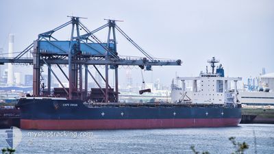
CAPE SWAN
Bulk Carrier
Current Trip
CSEI
| Time Travelled | 43 days |
|---|---|
| Remaining Time | --- |
| Distance Travelled | 10700.50 nm |
| Remaining Distance | --- |
| AVG Speed | 11.1 Knots |
| MAX Speed | 14.8 Knots |
| AVG Wind | 12.9 knots |
| MAX Wind | 30.4 knots |
| MIN Temp | 8.3°C / 46.94°F |
| MAX Temp | 29.3°C / 84.74°F |
| Draught | 11 m |
| Position Received | 2 d ago |
Current Position
| Longitude | -35.67978° |
|---|---|
| Latitude | 40.65543° |
| Status | Under way using engine |
| Speed | 11.9 Knots |
| Course | 279.2° |
| Area | North Atlantic Ocean |
| Station | T-AIS |
| Position Received | 2 d ago |
Info
Information
The current position of CAPE SWAN is in North Atlantic Ocean with coordinates 40.65543° / -35.67978° as reported on 2024-05-14 23:16 by AIS to our vessel tracker app. The vessel's current speed is 11.9 Knots
The vessel CAPE SWAN (IMO: 9552381, MMSI: 636020563) is a Bulk Carrier that was built in 2012 ( 12 years old ). It's sailing under the flag of [LR] Liberia.
In this page you can find informations about the vessels current position, last detected port calls, and current voyage information. If the vessels is not in coverage by AIS you will find the latest position.
The current position of CAPE SWAN is detected by our AIS receivers and we are not responsible for the reliability of the data. The last position was recorded while the vessel was in Coverage by the Ais receivers of our vessel tracking app.
The current draught of CAPE SWAN as reported by AIS is 11 meters
Weather
| Temperature | 9.5°C / 49.1°F |
|---|---|
| Wind Speed | 8 knots |
| Direction | 289° WNW |
| Pressure | 1016 hPa |
| Humidity | 91.8 % |
| Cloud Coverage | 100 % |
Featured Company
Last Port Calls
| Port | Arrival | Departure | Time In Port |
|---|---|---|---|
| 2024-03-31 17:36 | 2024-04-03 12:30 | 2 d | |
| 2024-03-08 09:29 | 2024-03-13 09:25 | 4 d |
Last Trips
| Origin | Departure | Destination | Arrival | Distance | |
|---|---|---|---|---|---|
| 2024-03-13 10:25 | 2024-03-31 12:36 | 4644.09 nm | |||
| 2024-02-16 14:33 | 2024-03-08 10:29 | 5384.47 nm |
Events
| Time | Event | Details | Position / Dest | Info |
|---|---|---|---|---|
| 2024-05-14 23:22 | Status Changed | Default Under way using engine |
40.65833 / -35.70500
CSEI
|
Speed: 11.9 kn Course: 279.2° |
| 2024-05-14 23:16 | OUT of Coverage |
40.65543 / -35.67978
North Atlantic Ocean
CSEI
|
Speed: 11.9 kn Course: 279.2° |
|
| 2024-05-14 23:11 | Status Changed | Under way using engine Default |
40.65309 / -35.66140
CSEI
|
Speed: 11 kn Course: 279° |
| 2024-05-14 23:04 | Status Changed | Default Under way using engine |
40.64834 / -35.62833
CSEI
|
Speed: 12 kn Course: 278.9° |
| 2024-05-14 22:47 | Status Changed | Under way using engine Default |
40.63898 / -35.55674
CSEI
|
Speed: 12 kn Course: 280° |
| 2024-05-14 22:43 | Status Changed | Default Under way using engine |
40.63500 / -35.53667
CSEI
|
Speed: 12 kn Course: 281.8° |
| 2024-05-14 22:05 | Detected in Sea | High seas of the North Atlantic Ocean |
40.61005 / -35.37235
North Atlantic Ocean
CSEI
|
Speed: 12.1 kn Course: 282.8° |
| 2024-05-14 20:57 | Status Changed | Under way using engine Default |
40.56557 / -35.07716
CSEI
|
Speed: 12 kn Course: 281° |
| 2024-05-14 20:46 | IN Coverage |
40.56557 / -35.07716
North Atlantic Ocean
CSEI
|
Speed: 11.9 kn Course: 278.5° |
|
| 2024-05-14 19:31 | OUT of Coverage |
40.51189 / -34.70047
North Atlantic Ocean
CSEI
|
Speed: 12.4 kn Course: 280.4° |