
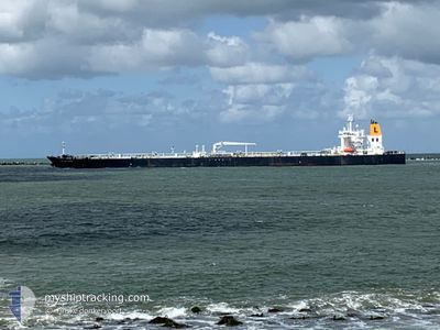
CAPTAIN PARIS
Tanker
Current Trip
| Time Travelled | 5 days |
|---|---|
| Remaining Time | --- |
| Distance Travelled | 1084.87 nm |
| Remaining Distance | --- |
| AVG Speed | 11 Knots |
| MAX Speed | 13.4 Knots |
| AVG Wind | 12.8 knots |
| MAX Wind | 26.4 knots |
| MIN Temp | 14.9°C / 58.82°F |
| MAX Temp | 31.3°C / 88.34°F |
| Draught | 8.6 m |
| Position Received | 2 d ago |
Current Position
| Longitude | 40.17871° |
|---|---|
| Latitude | 18.41584° |
| Status | Under way using engine |
| Speed | 12.4 Knots |
| Course | 147° |
| Area | Red Sea |
| Station | T-AIS |
| Position Received | 2 d ago |
Info
Information
The current position of CAPTAIN PARIS is in Red Sea with coordinates 18.41584° / 40.17871° as reported on 2024-05-16 22:36 by AIS to our vessel tracker app. The vessel's current speed is 12.4 Knots
The vessel CAPTAIN PARIS (IMO: 9692844, MMSI: 229716000) is a Tanker It's sailing under the flag of [MT] Malta.
In this page you can find informations about the vessels current position, last detected port calls, and current voyage information. If the vessels is not in coverage by AIS you will find the latest position.
The current position of CAPTAIN PARIS is detected by our AIS receivers and we are not responsible for the reliability of the data. The last position was recorded while the vessel was in Coverage by the Ais receivers of our vessel tracking app.
The current draught of CAPTAIN PARIS as reported by AIS is 8.6 meters
Weather
| Temperature | 31.8°C / 89.24°F |
|---|---|
| Wind Speed | 7 knots |
| Direction | 221° SW |
| Pressure | 1008 hPa |
| Humidity | 65.4 % |
| Cloud Coverage | 40 % |
Featured Company
Last Port Calls
| Port | Arrival | Departure | Time In Port |
|---|---|---|---|
| 2024-05-13 17:56 | 2024-05-14 03:18 | 9 h | |
| 2024-05-13 17:04 | 2024-05-13 17:52 | 48 m | |
| 2024-04-23 13:04 | 2024-04-25 11:48 | 1 d | |
| 2024-03-06 19:58 | 2024-03-08 14:42 | 1 d |
Most Visited Ports (Last year)
| Port | Arrivals | |
|---|---|---|
| 5 | ||
| 3 | ||
| 2 | ||
| 2 | ||
| 2 | ||
| 2 |
Last Trips
| Origin | Departure | Destination | Arrival | Distance | |
|---|---|---|---|---|---|
| 2024-05-13 19:52 | 2024-05-13 19:56 | 0.70 nm | |||
| 2024-04-25 14:48 | 2024-05-13 19:04 | 4774.22 nm | |||
| 2024-03-08 17:42 | 2024-04-23 16:04 | 12865.40 nm | |||
| 2024-02-17 18:53 | 2024-03-06 22:58 | 3908.37 nm |
Events
| Time | Event | Details | Position / Dest | Info |
|---|---|---|---|---|
| 2024-05-17 15:25 | STOP Moving |
17.26776 / 42.17560
SAGIZ
|
Speed: Course: 294° |
|
| 2024-05-16 22:41 | Status Changed | Default Under way using engine |
18.40279 / 40.18755
SAGIZ
|
Speed: 12.4 kn Course: 147° |
| 2024-05-16 22:36 | OUT of Coverage |
18.41584 / 40.17871
Red Sea
SAGIZ
|
Speed: 12.4 kn Course: 147° |
|
| 2024-05-16 22:22 | Status Changed | Under way using engine Default |
18.45968 / 40.14891
SAGIZ
|
Speed: 12.4 kn Course: 147° |
| 2024-05-16 22:12 | Status Changed | Default Under way using engine |
18.48599 / 40.13113
SAGIZ
|
Speed: 12.3 kn Course: 147.1° |
| 2024-05-16 22:09 | Status Changed | Under way using engine Default |
18.49711 / 40.12365
SAGIZ
|
Speed: 12.3 kn Course: 148° |
| 2024-05-16 21:55 | Status Changed | Default Under way using engine |
18.53446 / 40.09884
SAGIZ
|
Speed: 12.3 kn Course: 147.5° |
| 2024-05-16 21:50 | Status Changed | Under way using engine Default |
18.55186 / 40.08727
SAGIZ
|
Speed: 12.3 kn Course: 147° |
| 2024-05-16 21:40 | Status Changed | Default Under way using engine |
18.57883 / 40.06930
SAGIZ
|
Speed: 12.3 kn Course: 147.9° |
| 2024-05-16 21:13 | Status Changed | Under way using engine Default |
18.67198 / 40.00787
SAGIZ
|
Speed: 12.1 kn Course: 148° |