
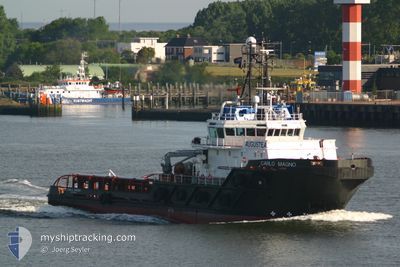
CARLO MAGNO
Anchor Handling Vessel
Current Trip
OPL DURBAN
| Time Travelled | 24 days |
|---|---|
| Remaining Time | --- |
| Distance Travelled | 1581.22 nm |
| Remaining Distance | --- |
| AVG Speed | 6.3 Knots |
| MAX Speed | 12.4 Knots |
| AVG Wind | 15.2 knots |
| MAX Wind | 37.8 knots |
| MIN Temp | 12.8°C / 55.04°F |
| MAX Temp | 24.5°C / 76.1°F |
| Draught | 6.2 m |
| Position Received | 3 d ago |
Current Position
| Longitude | 31.71157° |
|---|---|
| Latitude | -29.67632° |
| Status | Restricted manoeuverability |
| Speed | 1 Knots |
| Course | 58° |
| Area | Indian Ocean |
| Station | T-AIS |
| Position Received | 3 d ago |
Info
Information
The current position of CARLO MAGNO is in Indian Ocean with coordinates -29.67632° / 31.71157° as reported on 2024-06-24 15:18 by AIS to our vessel tracker app. The vessel's current speed is 1 Knots
The vessel CARLO MAGNO (IMO: 9341251, MMSI: 247153600) is a Anchor Handling Vessel that was built in 2006 ( 18 years old ). It's sailing under the flag of [IT] Italy.
In this page you can find informations about the vessels current position, last detected port calls, and current voyage information. If the vessels is not in coverage by AIS you will find the latest position.
The current position of CARLO MAGNO is detected by our AIS receivers and we are not responsible for the reliability of the data. The last position was recorded while the vessel was in Coverage by the Ais receivers of our vessel tracking app.
The current draught of CARLO MAGNO as reported by AIS is 6.2 meters
Weather
| Temperature | 20.9°C / 69.62°F |
|---|---|
| Wind Speed | 6 knots |
| Direction | 119° ESE |
| Pressure | 1028.9 hPa |
| Humidity | 70.2 % |
| Cloud Coverage | 1 % |
Featured Company
Last Port Calls
| Port | Arrival | Departure | Time In Port |
|---|---|---|---|
| 2024-05-30 14:47 | 2024-06-03 15:32 | 4 d | |
| 2024-04-30 10:15 | 2024-05-02 13:51 | 2 d |
Most Visited Ports (Last year)
| Port | Arrivals | |
|---|---|---|
| 4 | ||
| 2 | ||
| 2 | ||
| 2 | ||
| 2 | ||
| 1 |
Last Trips
| Origin | Departure | Destination | Arrival | Distance | |
|---|---|---|---|---|---|
| 2024-05-02 15:51 | 2024-05-30 16:47 | 2171.82 nm | |||
| 2024-02-23 22:29 | 2024-04-30 12:15 | 5810.60 nm |
Events
| Time | Event | Details | Position / Dest | Info |
|---|---|---|---|---|
| 2024-06-26 23:07 | START Moving |
-25.60958 / 33.04508
OPL DURBAN
|
Speed: 4.8 kn Course: 92° |
|
| 2024-06-26 13:19 | STOP Moving |
-25.61205 / 33.04425
OPL DURBAN
|
Speed: Course: 333° |
|
| 2024-06-26 12:32 | START Moving |
-25.61527 / 33.04854
OPL DURBAN
|
Speed: 5.5 kn Course: 277° |
|
| 2024-06-26 12:07 | STOP Moving |
-25.62192 / 33.06260
OPL DURBAN
|
Speed: 0.3 kn Course: 163° |
|
| 2024-06-24 18:23 | START Moving |
-29.73923 / 31.73931
OPL DURBAN
|
Speed: 3.3 kn Course: 76° |
|
| 2024-06-24 15:22 | Status Changed | Default Restricted manoeuverability |
-29.67652 / 31.71198
OPL DURBAN
|
Speed: 1 kn Course: 58° |
| 2024-06-24 15:22 | STOP Moving |
-29.67652 / 31.71198
OPL DURBAN
|
Speed: 0.3 kn Course: 47° |
|
| 2024-06-24 15:18 | OUT of Coverage |
-29.67632 / 31.71157
Indian Ocean
|
Speed: 1 kn Course: 131.3° |
|
| 2024-06-24 14:18 | Status Changed | Restricted manoeuverability Default |
-29.66323 / 31.69335
OPL DURBAN
|
Speed: 0.4 kn Course: 49° |
| 2024-06-24 14:15 | Status Changed | Default Restricted manoeuverability |
-29.66348 / 31.69277
OPL DURBAN
|
Speed: 0.4 kn Course: 52° |