
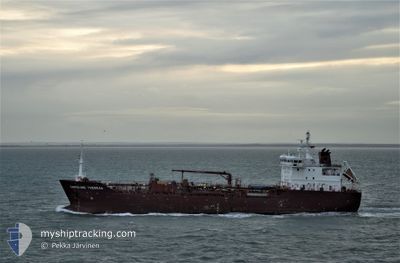
CAROLINE THERESE
Oil/Chemical Tanker
Current Trip
| Time Travelled | 3 days |
|---|---|
| Remaining Time | --- |
| Distance Travelled | 900.40 nm |
| Remaining Distance | --- |
| AVG Speed | 11 Knots |
| MAX Speed | 13 Knots |
| AVG Wind | 16.1 knots |
| MAX Wind | 21.9 knots |
| MIN Temp | 19.1°C / 66.38°F |
| MAX Temp | 23.5°C / 74.3°F |
| Draught | 7.5 m |
| Position Received | 3 d ago |
Current Position
| Longitude | -15.28106° |
|---|---|
| Latitude | 27.69520° |
| Status | Under way using engine |
| Speed | 11.2 Knots |
| Course | 191.4° |
| Area | North Atlantic Ocean |
| Station | T-AIS |
| Position Received | 3 d ago |
Info
Information
The current position of CAROLINE THERESE is in North Atlantic Ocean with coordinates 27.69520° / -15.28106° as reported on 2024-05-18 22:58 by AIS to our vessel tracker app. The vessel's current speed is 11.2 Knots and is heading at the port of LAGOS. The estimated time of arrival as calculated by vessel tracking app is 2024-05-29 22:00 LT
The vessel CAROLINE THERESE (IMO: 9428449, MMSI: 220637000) is a Oil/Chemical Tanker that was built in 2009 ( 15 years old ). It's sailing under the flag of [DK] Denmark.
In this page you can find informations about the vessels current position, last detected port calls, and current voyage information. If the vessels is not in coverage by AIS you will find the latest position.
The current position of CAROLINE THERESE is detected by our AIS receivers and we are not responsible for the reliability of the data. The last position was recorded while the vessel was in Coverage by the Ais receivers of our vessel tracking app.
The current draught of CAROLINE THERESE as reported by AIS is 7.5 meters
Weather
| Temperature | 23.5°C / 74.3°F |
|---|---|
| Wind Speed | 10 knots |
| Direction | 328° NNW |
| Pressure | 1012.7 hPa |
| Humidity | 82 % |
| Cloud Coverage | 62 % |
Featured Company
Last Port Calls
| Port | Arrival | Departure | Time In Port |
|---|---|---|---|
| 2024-05-18 08:42 | 2024-05-18 20:10 | 11 h | |
| 2024-05-14 13:00 | 2024-05-15 09:26 | 20 h | |
| 2024-05-09 20:06 | 2024-05-09 20:53 | 47 m | |
| 2024-05-08 11:02 | 2024-05-08 12:18 | 1 h | |
| 2024-05-01 15:23 | 2024-05-03 18:21 | 2 d | |
| 2024-04-15 14:36 | 2024-04-16 19:01 | 1 d | |
| 2024-03-09 08:10 | 2024-04-09 13:25 | ||
| 2024-03-09 07:56 |
Most Visited Ports (Last year)
| Port | Arrivals | |
|---|---|---|
| 15 | ||
| 14 | ||
| 3 | ||
| 3 | ||
| 3 | ||
| 2 |
Last Trips
| Origin | Departure | Destination | Arrival | Distance | |
|---|---|---|---|---|---|
| 2024-05-15 11:26 | 2024-05-18 09:42 | 736.64 nm | |||
| 2024-05-09 22:53 | 2024-05-14 15:00 | 1322.54 nm | |||
| 2024-05-08 14:18 | 2024-05-09 22:06 | 2.87 nm | |||
| 2024-05-03 20:21 | 2024-05-08 13:02 | 288.50 nm | |||
| 2024-04-16 22:01 | 2024-05-01 17:23 | 2962.87 nm | |||
| 2024-04-09 16:25 | 2024-04-15 17:36 | 441.67 nm | |||
| 2024-03-09 10:56 | 2024-03-09 11:10 | 0.29 nm |
Events
| Time | Event | Details | Position / Dest | Info |
|---|---|---|---|---|
| 2024-05-18 23:07 | Status Changed | Default Under way using engine |
27.67059 / -15.28676
LAGOS
|
Speed: 11.2 kn Course: 191.4° |
| 2024-05-18 22:58 | OUT of Coverage |
27.69520 / -15.28106
North Atlantic Ocean
LAGOS
|
Speed: 11.2 kn Course: 191.4° |
|
| 2024-05-18 20:45 | ETA Changed | 2024/05/29 22:00 2024/05/28 03:00 |
28.07089 / -15.31716
LAGOS
|
Speed: 10.7 kn Course: 130.6° |
| 2024-05-18 20:36 | Draught Changed | 7.5 7.4 |
28.08703 / -15.33946
LAGOS
|
Speed: 10.8 kn Course: 126.1° |
| 2024-05-18 20:36 | Destination Changed | LAGOS LAS PALMAS |
28.08703 / -15.33946
LAGOS
|
Speed: 10.8 kn Course: 126.1° |
| 2024-05-18 20:36 | ETA Changed | 2024/05/28 03:00 2024/05/18 03:00 |
28.08703 / -15.33946
LAGOS
|
Speed: 10.8 kn Course: 126.1° |
| 2024-05-18 20:10 | PORT DEPARTURE |
|
28.14594 / -15.39610
LAS PALMAS
|
Speed: 7.9 kn Course: 119° |
| 2024-05-18 20:05 | START Moving |
28.15339 / -15.40015
[ES] LAS PALMAS
|
Speed: 5.1 kn Course: 201° |
|
| 2024-05-18 19:54 | Status Changed | Under way using engine Moored |
28.15710 / -15.39848
[ES] LAS PALMAS
|
Speed: Course: 179° |
| 2024-05-18 19:45 | Status Changed | Moored Default |
28.15709 / -15.39847
[ES] LAS PALMAS
|
Speed: Course: 179° |