
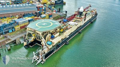
CASTORO 10
Pipe Burying Vessel
Current Trip
| Time Travelled | 1 day |
|---|---|
| Remaining Time | --- |
| Distance Travelled | 140.40 nm |
| Remaining Distance | --- |
| AVG Speed | 5 Knots |
| MAX Speed | 6.5 Knots |
| AVG Wind | 14.3 knots |
| MAX Wind | 26 knots |
| MIN Temp | 17.4°C / 63.32°F |
| MAX Temp | 19.5°C / 67.1°F |
| Draught | 4.3 m |
| Position Received | 1 m ago |
Current Position
| Longitude | 10.12706° |
|---|---|
| Latitude | 42.21041° |
| Status | Restricted manoeuverability |
| Speed | 6 Knots |
| Course | 133.2° |
| Area | Tyrrhenian Sea |
| Station | T-AIS |
| Position Received | 1 m ago |
Info
Information
The current position of CASTORO 10 is in Tyrrhenian Sea with coordinates 42.21041° / 10.12706° as reported on 2024-05-23 16:49 by AIS to our vessel tracker app. The vessel's current speed is 6 Knots and is heading at the port of ORTONA. The estimated time of arrival as calculated by vessel tracking app is 2024-05-30 12:00 LT
The vessel CASTORO 10 (IMO: 7503166, MMSI: 308687000) is a Pipe Burying Vessel that was built in 1976 ( 48 years old ). It's sailing under the flag of [BS] Bahamas.
In this page you can find informations about the vessels current position, last detected port calls, and current voyage information. If the vessels is not in coverage by AIS you will find the latest position.
The current position of CASTORO 10 is detected by our AIS receivers and we are not responsible for the reliability of the data. The last position was recorded while the vessel was in Coverage by the Ais receivers of our vessel tracking app.
The current draught of CASTORO 10 as reported by AIS is 4.3 meters
Weather
| Temperature | 19.2°C / 66.56°F |
|---|---|
| Wind Speed | 1 knots |
| Direction | 264° W |
| Pressure | 1017.1 hPa |
| Humidity | 70.1 % |
| Cloud Coverage | --- |
Featured Company
Last Port Calls
| Port | Arrival | Departure | Time In Port |
|---|---|---|---|
| 2024-03-21 08:19 | 2024-05-22 13:15 | ||
| 2024-03-09 13:58 |
Most Visited Ports (Last year)
| Port | Arrivals | |
|---|---|---|
| 3 | ||
| 2 | ||
| 1 | ||
| 1 | ||
| 1 | ||
| 1 |
Last Trips
| Origin | Departure | Destination | Arrival | Distance | |
|---|---|---|---|---|---|
| 2024-03-09 14:58 | 2024-03-21 09:19 | 1692.74 nm |
Events
| Time | Event | Details | Position / Dest | Info |
|---|---|---|---|---|
| 2024-05-23 12:44 | Change Sea Area | Italian part of the Tyrrhenian Sea French part of the Tyrrhenian Sea |
42.52298 / 9.82115
Tyrrhenian Sea
ORTONA
|
Speed: 5.7 kn Course: 154.6° |
| 2024-05-23 05:55 | Change Sea Area | French part of the Tyrrhenian Sea French part of the Ligurian Sea |
43.13984 / 9.55207
Tyrrhenian Sea
ORTONA
|
Speed: 5.2 kn Course: 159.2° |
| 2024-05-23 05:55 | IN Coverage |
43.13984 / 9.55207
Tyrrhenian Sea
ORTONA
|
Speed: 5.2 kn Course: 159.2° |
|
| 2024-05-23 04:43 | OUT of Coverage |
43.23312 / 9.50250
Ligurian Sea
ORTONA
|
Speed: 4.7 kn Course: 168.4° |
|
| 2024-05-23 03:06 | Detected in Sea | French part of the Ligurian Sea |
43.35562 / 9.44563
Ligurian Sea
ORTONA
|
Speed: 5.1 kn Course: 160.3° |
| 2024-05-23 00:11 | Draught Changed | 4.3 3.9 |
43.57020 / 9.33837
ORTONA
|
Speed: 4.4 kn Course: 180° |
| 2024-05-22 14:59 | Draught Changed | 3.9 4 |
44.25817 / 8.98858
ORTONA
|
Speed: 5.7 kn Course: 156.5° |
| 2024-05-22 14:59 | Destination Changed | ORTONA GENOVA |
44.25817 / 8.98858
ORTONA
|
Speed: 5.7 kn Course: 156.5° |
| 2024-05-22 14:59 | ETA Changed | 2024/05/30 12:00 2025/03/21 07:00 |
44.25817 / 8.98858
ORTONA
|
Speed: 5.7 kn Course: 156.5° |
| 2024-05-22 14:58 | Status Changed | Restricted manoeuverability Moored |
44.26038 / 8.98758
GENOVA
|
Speed: 5.6 kn Course: 164.6° |