
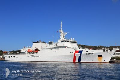
CG5002 HSINCHU
Law Enforcement
Current Trip
| Trip Time | 13 days |
|---|---|
| Trip Distance | 4410.92 nm |
| AVG Speed | 9.5 Knots |
| MAX Speed | 13.6 Knots |
| Draught | 4.6 m |
| AVG Wind | 17.5 knots |
| MAX Wind | 19.6 knots |
| MIN Temp | 23.7°C / 74.66°F |
| MAX Temp | 26.7°C / 80.06°F |
| Position Received | 8 h, 55 m ago |
Current Position
| Longitude | -157.87669° |
|---|---|
| Latitude | 21.31293° |
| Status | Under way using engine |
| Speed | 0.1 Knots |
| Course | 305° |
| Area | North Pacific Ocean |
| Station | T-AIS |
| Position Received | 8 h, 55 m ago |
Info
Information
The current position of CG5002 HSINCHU is in North Pacific Ocean with coordinates 21.31293° / -157.87669° as reported on 2024-06-16 16:17 by AIS to our vessel tracker app. The vessel's current speed is 0.1 Knots and is currently inside the port of HONOLULU .
The vessel CG5002 HSINCHU (MMSI: 416006646) is a Law Enforcement It's sailing under the flag of [TW] Taiwan.
In this page you can find informations about the vessels current position, last detected port calls, and current voyage information. If the vessels is not in coverage by AIS you will find the latest position.
The current position of CG5002 HSINCHU is detected by our AIS receivers and we are not responsible for the reliability of the data. The last position was recorded while the vessel was in Coverage by the Ais receivers of our vessel tracking app.
The current draught of CG5002 HSINCHU as reported by AIS is 4.6 meters
Weather
| Temperature | 23.7°C / 74.66°F |
|---|---|
| Wind Speed | 16 knots |
| Direction | 62° ENE |
| Pressure | 1017.9 hPa |
| Humidity | 73.5 % |
| Cloud Coverage | --- |
Featured Company
Events
| Time | Event | Details | Position / Dest | Info |
|---|---|---|---|---|
| 2024-06-16 16:17 | OUT of Coverage |
21.31293 / -157.87669
North Pacific Ocean
[US] HONOLULU
|
Speed: 0.1 kn Course: 35° |
|
| 2024-06-16 16:10 | STOP Moving |
21.31288 / -157.87677
[US] HONOLULU
|
Speed: 0.2 kn Course: 318° |
|
| 2024-06-16 15:56 | IN Coverage |
21.30650 / -157.86669
North Pacific Ocean
[US] HONOLULU
|
Speed: 0.6 kn Course: 294.5° |
|
| 2024-06-11 23:34 | OUT of Coverage |
21.30652 / -157.86656
North Pacific Ocean
[US] HONOLULU
|
Speed: Course: 0° |
|
| 2024-06-11 23:27 | STOP Moving |
21.30655 / -157.86655
[US] HONOLULU
|
Speed: 0.1 kn Course: 355° |
|
| 2024-06-11 23:10 | PORT ARRIVAL |
|
21.29518 / -157.87121
[US] HONOLULU
|
Speed: 7.4 kn Course: 26.5° |
| 2024-06-11 20:58 | Destination Changed | HNL PATROL . |
21.19577 / -158.17552
HNL
|
Speed: 10.6 kn Course: 90.4° |
| 2024-06-11 20:58 | ETA Changed | 2024/06/11 13:00 2024/12/01 12:00 |
21.19577 / -158.17552
HNL
|
Speed: 10.6 kn Course: 90.4° |
| 2024-06-11 19:32 | Detected in Sea | United States (Hawaii) part of the North Pacific Ocean |
21.22545 / -158.43822
North Pacific Ocean
|
Speed: 11.4 kn Course: 99.4° |
| 2024-06-11 19:32 | IN Coverage |
21.22545 / -158.43822
North Pacific Ocean
|
Speed: 11.4 kn Course: 99.4° |