
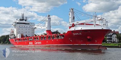
CHARLIE
Cargo
Current Trip
| Time Travelled | 2 days |
|---|---|
| Remaining Time | --- |
| Distance Travelled | 895.19 nm |
| Remaining Distance | --- |
| AVG Speed | 12.9 Knots |
| MAX Speed | 15.4 Knots |
| AVG Wind | 14.5 knots |
| MAX Wind | 28.2 knots |
| MIN Temp | 13.4°C / 56.12°F |
| MAX Temp | 17°C / 62.6°F |
| Draught | 6.9 m |
| Position Received | 20 h, 5 m ago |
Current Position
| Longitude | -5.59339° |
|---|---|
| Latitude | 48.98310° |
| Status | Under way using engine |
| Speed | 14.9 Knots |
| Course | 237.6° |
| Area | Celtic Sea |
| Station | T-AIS |
| Position Received | 20 h, 5 m ago |
Info
Information
The current position of CHARLIE is in Celtic Sea with coordinates 48.98310° / -5.59339° as reported on 2024-06-17 15:41 by AIS to our vessel tracker app. The vessel's current speed is 14.9 Knots and is heading at the port of JIANGYIN. The estimated time of arrival as calculated by vessel tracking app is 2024-08-01 10:00 LT
The vessel CHARLIE (IMO: 9736236, MMSI: 305543000) is a Cargo It's sailing under the flag of [AG] Antigua Barbuda.
In this page you can find informations about the vessels current position, last detected port calls, and current voyage information. If the vessels is not in coverage by AIS you will find the latest position.
The current position of CHARLIE is detected by our AIS receivers and we are not responsible for the reliability of the data. The last position was recorded while the vessel was in Coverage by the Ais receivers of our vessel tracking app.
The current draught of CHARLIE as reported by AIS is 6.9 meters
Weather
| Temperature | 17°C / 62.6°F |
|---|---|
| Wind Speed | 6 knots |
| Direction | 97° E |
| Pressure | 1011.2 hPa |
| Humidity | 85.5 % |
| Cloud Coverage | --- |
Featured Company
Last Port Calls
| Port | Arrival | Departure | Time In Port |
|---|---|---|---|
| 2024-06-13 15:14 | 2024-06-15 15:00 | 1 d | |
| 2024-06-01 18:50 | 2024-06-03 00:15 | 1 d | |
| 2024-05-31 09:01 | 2024-05-31 09:35 | 34 m | |
| 2024-05-29 06:05 | 2024-05-29 07:11 | 1 h | |
| 2024-05-25 03:46 | 2024-05-28 03:44 | 2 d | |
| 2024-05-23 23:04 | 2024-05-23 23:53 | 49 m | |
| 2024-05-21 13:40 | 2024-05-21 19:01 | 5 h | |
| 2024-05-20 04:11 | 2024-05-20 04:56 | 44 m | |
| 2024-05-05 16:45 | 2024-05-07 14:11 | 1 d | |
| 2024-04-22 14:33 | 2024-04-24 23:10 | 2 d |
Most Visited Ports (Last year)
| Port | Arrivals | |
|---|---|---|
| 3 | ||
| 2 | ||
| 2 | ||
| 2 | ||
| 2 | ||
| 1 |
Last Trips
| Origin | Departure | Destination | Arrival | Distance | |
|---|---|---|---|---|---|
| 2024-06-02 20:15 | 2024-06-13 17:14 | 3450.67 nm | |||
| 2024-05-31 05:35 | 2024-06-01 14:50 | 297.86 nm | |||
| 2024-05-29 03:11 | 2024-05-31 05:01 | 526.84 nm | |||
| 2024-05-27 22:44 | 2024-05-29 02:05 | 345.28 nm | |||
| 2024-05-23 19:53 | 2024-05-24 22:46 | 346.09 nm | |||
| 2024-05-21 15:01 | 2024-05-23 19:04 | 522.76 nm | |||
| 2024-05-20 00:56 | 2024-05-21 09:40 | 297.01 nm | |||
| 2024-05-07 09:11 | 2024-05-20 00:11 | 3608.65 nm | |||
| 2024-04-24 19:10 | 2024-05-05 11:45 | 2032.71 nm | |||
| 2024-03-14 09:26 | 2024-04-22 10:33 | 10979.59 nm |
Events
| Time | Event | Details | Position / Dest | Info |
|---|---|---|---|---|
| 2024-06-17 15:47 | Status Changed | Default Under way using engine |
48.96865 / -5.62820
CNJIA
|
Speed: 14.9 kn Course: 237.6° |
| 2024-06-17 15:41 | Status Changed | Under way using engine Default |
48.98310 / -5.59339
CNJIA
|
Speed: 14.8 kn Course: 238° |
| 2024-06-17 15:41 | OUT of Coverage |
48.98310 / -5.59339
Celtic Sea
|
Speed: 14.9 kn Course: 237.6° |
|
| 2024-06-17 15:27 | Status Changed | Default Under way using engine |
49.01254 / -5.52252
CNJIA
|
Speed: 14.6 kn Course: 237.3° |
| 2024-06-17 15:18 | Status Changed | Under way using engine Default |
49.03350 / -5.47044
CNJIA
|
Speed: 14.4 kn Course: 239° |
| 2024-06-17 14:28 | Status Changed | Default Under way using engine |
49.12593 / -5.21832
CNJIA
|
Speed: 11.8 kn Course: 242.3° |
| 2024-06-17 14:25 | Status Changed | Under way using engine Default |
49.13142 / -5.20238
CNJIA
|
Speed: 11.3 kn Course: 242° |
| 2024-06-17 14:17 | Status Changed | Default Under way using engine |
49.14240 / -5.17016
CNJIA
|
Speed: 11.3 kn Course: 242.3° |
| 2024-06-17 14:11 | Status Changed | Under way using engine Default |
49.15172 / -5.14346
CNJIA
|
Speed: 11.2 kn Course: 241° |
| 2024-06-17 13:51 | Status Changed | Default Under way using engine |
49.18227 / -5.06281
CNJIA
|
Speed: 11.1 kn Course: 241.5° |