
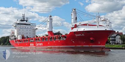
CHARLIE
Cargo
Current Trip
| Time Travelled | 7 days |
|---|---|
| Remaining Time | --- |
| Distance Travelled | 2533.49 nm |
| Remaining Distance | --- |
| AVG Speed | 13.3 Knots |
| MAX Speed | 19 Knots |
| AVG Wind | 9.3 knots |
| MAX Wind | 19.3 knots |
| MIN Temp | 6.4°C / 43.52°F |
| MAX Temp | 20.7°C / 69.26°F |
| Draught | 6.8 m |
| Position Received | 7 d ago |
Current Position
| Longitude | -70.65731° |
|---|---|
| Latitude | 47.15981° |
| Status | Under way using engine |
| Speed | 15.8 Knots |
| Course | 35.8° |
| Area | Gulf of St-Lawrence |
| Station | T-AIS |
| Position Received | 7 d ago |
Info
Information
The current position of CHARLIE is in Gulf of St-Lawrence with coordinates 47.15981° / -70.65731° as reported on 2024-06-03 11:52 by AIS to our vessel tracker app. The vessel's current speed is 15.8 Knots and is heading at the port of EMDEN. The estimated time of arrival as calculated by vessel tracking app is 2024-06-14 03:00 LT
The vessel CHARLIE (IMO: 9736236, MMSI: 305543000) is a Cargo It's sailing under the flag of [AG] Antigua Barbuda.
In this page you can find informations about the vessels current position, last detected port calls, and current voyage information. If the vessels is not in coverage by AIS you will find the latest position.
The current position of CHARLIE is detected by our AIS receivers and we are not responsible for the reliability of the data. The last position was recorded while the vessel was in Coverage by the Ais receivers of our vessel tracking app.
The current draught of CHARLIE as reported by AIS is 6.8 meters
Weather
| Temperature | 13.2°C / 55.76°F |
|---|---|
| Wind Speed | 6 knots |
| Direction | 341° NNW |
| Pressure | 1023.6 hPa |
| Humidity | 79.7 % |
| Cloud Coverage | 100 % |
Featured Company
Last Port Calls
| Port | Arrival | Departure | Time In Port |
|---|---|---|---|
| 2024-06-01 18:50 | 2024-06-03 00:15 | 1 d | |
| 2024-05-31 09:01 | 2024-05-31 09:35 | 34 m | |
| 2024-05-29 06:05 | 2024-05-29 07:11 | 1 h | |
| 2024-05-25 03:46 | 2024-05-28 03:44 | 2 d | |
| 2024-05-23 23:04 | 2024-05-23 23:53 | 49 m | |
| 2024-05-21 13:40 | 2024-05-21 19:01 | 5 h | |
| 2024-05-20 04:11 | 2024-05-20 04:56 | 44 m | |
| 2024-05-05 16:45 | 2024-05-07 14:11 | 1 d | |
| 2024-04-22 14:33 | 2024-04-24 23:10 | 2 d |
Most Visited Ports (Last year)
| Port | Arrivals | |
|---|---|---|
| 3 | ||
| 2 | ||
| 2 | ||
| 2 | ||
| 2 | ||
| 1 |
Last Trips
| Origin | Departure | Destination | Arrival | Distance | |
|---|---|---|---|---|---|
| 2024-05-31 05:35 | 2024-06-01 14:50 | 297.86 nm | |||
| 2024-05-29 03:11 | 2024-05-31 05:01 | 526.84 nm | |||
| 2024-05-27 22:44 | 2024-05-29 02:05 | 345.28 nm | |||
| 2024-05-23 19:53 | 2024-05-24 22:46 | 346.09 nm | |||
| 2024-05-21 15:01 | 2024-05-23 19:04 | 522.76 nm | |||
| 2024-05-20 00:56 | 2024-05-21 09:40 | 297.01 nm | |||
| 2024-05-07 09:11 | 2024-05-20 00:11 | 3608.65 nm | |||
| 2024-04-24 19:10 | 2024-05-05 11:45 | 2032.71 nm | |||
| 2024-03-14 09:26 | 2024-04-22 10:33 | 10979.59 nm |
Events
| Time | Event | Details | Position / Dest | Info |
|---|---|---|---|---|
| 2024-06-03 11:54 | Status Changed | Default Under way using engine |
47.16667 / -70.64833
DEEME
|
Speed: 15.8 kn Course: 35.8° |
| 2024-06-03 11:52 | OUT of Coverage |
47.15981 / -70.65731
Gulf of St-Lawrence
DEEME
|
Speed: 15.8 kn Course: 35.8° |
|
| 2024-06-03 11:51 | Status Changed | Under way using engine Default |
47.15622 / -70.66103
DEEME
|
Speed: 16 kn Course: 34° |
| 2024-06-03 11:45 | Status Changed | Default Under way using engine |
47.13334 / -70.68166
DEEME
|
Speed: 16.9 kn Course: 32.3° |
| 2024-06-03 10:52 | Status Changed | Under way using engine Default |
46.93236 / -70.86217
DEEME
|
Speed: 15.2 kn Course: 33° |
| 2024-06-03 10:45 | Status Changed | Default Under way using engine |
46.90860 / -70.88500
DEEME
|
Speed: 15.5 kn Course: 53.9° |
| 2024-06-03 09:07 | Destination Changed | DEEME CAMTR |
46.74298 / -71.30007
DEEME
|
Speed: 11.1 kn Course: 73.6° |
| 2024-06-03 09:07 | ETA Changed | 2024/06/14 03:00 2024/06/01 21:00 |
46.74298 / -71.30007
DEEME
|
Speed: 11.1 kn Course: 73.6° |
| 2024-06-03 08:53 | Status Changed | Under way using engine Default |
46.72811 / -71.36016
CAMTR
|
Speed: 11.6 kn Course: 73° |
| 2024-06-03 08:36 | Status Changed | Default Under way using engine |
46.71457 / -71.43329
CAMTR
|
Speed: 10.8 kn Course: 77.6° |