
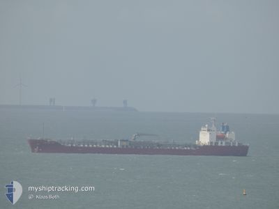
CHEM NEW YORK
Tanker C
Current Trip
| Time Travelled | 8 days |
|---|---|
| Remaining Time | --- |
| Distance Travelled | 2216.61 nm |
| Remaining Distance | --- |
| AVG Speed | 11.6 Knots |
| MAX Speed | 15.5 Knots |
| AVG Wind | 14.3 knots |
| MAX Wind | 24 knots |
| MIN Temp | 5.4°C / 41.72°F |
| MAX Temp | 17.8°C / 64.04°F |
| Draught | 9.3 m |
| Position Received | 1 m ago |
Current Position
| Longitude | 2.59211° |
|---|---|
| Latitude | 51.42301° |
| Status | At anchor |
| Speed | |
| Course | 217° |
| Area | North Sea |
| Station | T-AIS |
| Position Received | 1 m ago |
Info
Information
The current position of CHEM NEW YORK is in North Sea with coordinates 51.42301° / 2.59211° as reported on 2024-05-04 11:06 by AIS to our vessel tracker app. The vessel's current speed is 0 Knots
The vessel CHEM NEW YORK (IMO: 9705732, MMSI: 636016361) is a Tanker C It's sailing under the flag of [LR] Liberia.
In this page you can find informations about the vessels current position, last detected port calls, and current voyage information. If the vessels is not in coverage by AIS you will find the latest position.
The current position of CHEM NEW YORK is detected by our AIS receivers and we are not responsible for the reliability of the data. The last position was recorded while the vessel was in Coverage by the Ais receivers of our vessel tracking app.
The current draught of CHEM NEW YORK as reported by AIS is 9.3 meters
Weather
| Temperature | 12°C / 53.6°F |
|---|---|
| Wind Speed | 6 knots |
| Direction | 154° SSE |
| Pressure | 1012.7 hPa |
| Humidity | 80.9 % |
| Cloud Coverage | 53 % |
Featured Company
Last Port Calls
| Port | Arrival | Departure | Time In Port |
|---|---|---|---|
| 2024-04-25 04:54 | 2024-04-26 05:05 | 1 d | |
| 2024-04-22 20:53 | 2024-04-23 11:39 | 14 h | |
| 2024-04-21 09:16 | 2024-04-22 12:08 | 1 d | |
| 2024-04-17 04:45 | 2024-04-17 10:21 | 5 h | |
| 2024-03-07 10:01 | 2024-03-08 02:52 | 16 h | |
| 2024-03-01 05:57 |
Most Visited Ports (Last year)
| Port | Arrivals | |
|---|---|---|
| 2 | ||
| 1 | ||
| 1 | ||
| 1 | ||
| 1 | ||
| 1 |
Last Trips
| Origin | Departure | Destination | Arrival | Distance | |
|---|---|---|---|---|---|
| 2024-04-23 13:39 | 2024-04-25 06:54 | 433.93 nm | |||
| 2024-04-22 14:08 | 2024-04-22 22:53 | 96.77 nm | |||
| 2024-04-17 11:21 | 2024-04-21 11:16 | 1162.39 nm | |||
| 2024-03-08 10:52 | 2024-04-17 05:45 | 13354.31 nm | |||
| 2024-03-01 14:57 | 2024-03-07 18:01 | 998.86 nm |
Events
| Time | Event | Details | Position / Dest | Info |
|---|---|---|---|---|
| 2024-05-04 07:42 | Status Changed | At anchor Default |
51.42309 / 2.59188
BEANR
|
Speed: 0.4 kn Course: 242° |
| 2024-05-04 07:39 | Status Changed | Default At anchor |
51.42291 / 2.59206
BEANR
|
Speed: 0.4 kn Course: 251° |
| 2024-05-04 01:38 | Draught Changed | 9.3 9.2 |
51.42406 / 2.59096
BEANR
|
Speed: Course: 201° |
| 2024-05-03 18:45 | STOP Moving | 17.73 nm, North West of OOSTENDE |
51.42346 / 2.59222
BEANR
|
Speed: 0.1 kn Course: 225° |
| 2024-05-03 18:36 | Status Changed | At anchor Under way sailing |
51.42262 / 2.59114
BEANR
|
Speed: 0.8 kn Course: 259° |
| 2024-05-03 17:11 | Change Sea Area | Belgian part of the North Sea French part of the North Sea |
51.32621 / 2.36977
North Sea
BEANR
|
Speed: 9 kn Course: 50.2° |
| 2024-05-03 13:44 | Change Sea Area | French part of the North Sea French part of the English Channel |
51.02152 / 1.58933
North Sea
BEANR
|
Speed: 11.1 kn Course: 56° |
| 2024-05-03 10:58 | Change Sea Area | French part of the English Channel United Kingdom part of the English Channel |
50.59269 / 1.12778
English Channel
BEANR
|
Speed: 12.3 kn Course: 47.8° |
| 2024-05-03 10:58 | Status Changed | Under way sailing Default |
50.59269 / 1.12778
BEANR
|
Speed: 12.3 kn Course: 47° |
| 2024-05-03 10:56 | IN Coverage |
50.59269 / 1.12778
English Channel
BEANR
|
Speed: 12.3 kn Course: 47.8° |