
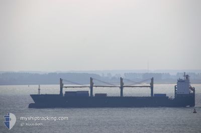
CHIPOL CHANGAN
General Cargo
Current Trip
CASTILLA
| Time Travelled | 11 days |
|---|---|
| Remaining Time | --- |
| Distance Travelled | 2031.09 nm |
| Remaining Distance | --- |
| AVG Speed | 11.6 Knots |
| MAX Speed | 15.8 Knots |
| AVG Wind | 11 knots |
| MAX Wind | 23.4 knots |
| MIN Temp | 12.5°C / 54.5°F |
| MAX Temp | 29.4°C / 84.92°F |
| Draught | 7.3 m |
| Position Received | 7 d ago |
Current Position
| Longitude | -79.54700° |
|---|---|
| Latitude | 25.60009° |
| Status | Under way using engine |
| Speed | 11.1 Knots |
| Course | 185.1° |
| Area | North Atlantic Ocean |
| Station | T-AIS |
| Position Received | 7 d ago |
Info
Information
The current position of CHIPOL CHANGAN is in North Atlantic Ocean with coordinates 25.60009° / -79.54700° as reported on 2024-05-20 22:26 by AIS to our vessel tracker app. The vessel's current speed is 11.1 Knots
The vessel CHIPOL CHANGAN (IMO: 9509645, MMSI: 636020206) is a General Cargo that was built in 2010 ( 14 years old ). It's sailing under the flag of [LR] Liberia.
In this page you can find informations about the vessels current position, last detected port calls, and current voyage information. If the vessels is not in coverage by AIS you will find the latest position.
The current position of CHIPOL CHANGAN is detected by our AIS receivers and we are not responsible for the reliability of the data. The last position was recorded while the vessel was in Coverage by the Ais receivers of our vessel tracking app.
The current draught of CHIPOL CHANGAN as reported by AIS is 7.3 meters
Weather
| Temperature | 28.8°C / 83.84°F |
|---|---|
| Wind Speed | 16 knots |
| Direction | 101° E |
| Pressure | 1011.7 hPa |
| Humidity | 81.5 % |
| Cloud Coverage | 5 % |
Featured Company
Last Port Calls
| Port | Arrival | Departure | Time In Port |
|---|---|---|---|
| 2024-05-06 01:53 | 2024-05-16 22:05 | 10 d | |
| 2024-04-26 01:54 | 2024-04-28 03:35 | 2 d | |
| 2024-04-23 09:23 | 2024-04-24 11:51 | 1 d | |
| 2024-04-15 23:20 | 2024-04-16 09:20 | 9 h |
Most Visited Ports (Last year)
| Port | Arrivals | |
|---|---|---|
| 2 | ||
| 2 | ||
| 2 | ||
| 1 | ||
| 1 | ||
| 1 |
Last Trips
| Origin | Departure | Destination | Arrival | Distance | |
|---|---|---|---|---|---|
| 2024-04-27 22:35 | 2024-05-05 21:53 | 1916.36 nm | |||
| 2024-04-24 06:51 | 2024-04-25 20:54 | 443.64 nm | |||
| 2024-04-16 03:20 | 2024-04-23 04:23 | 1756.32 nm | |||
| 2024-02-28 09:30 | 2024-04-15 17:20 | 14139.70 nm |
Events
| Time | Event | Details | Position / Dest | Info |
|---|---|---|---|---|
| 2024-05-23 16:24 | STOP Moving | 1.28 nm, South of PUERTO CASTILLA |
15.98432 / -85.95657
CASTILLA
|
Speed: 0.1 kn Course: 70° |
| 2024-05-20 22:26 | Status Changed | Default Under way using engine |
25.59854 / -79.54717
CASTILLA
|
Speed: 11.1 kn Course: 185.1° |
| 2024-05-20 22:26 | OUT of Coverage |
25.60009 / -79.54700
North Atlantic Ocean
CASTILLA
|
Speed: 11.1 kn Course: 185.1° |
|
| 2024-05-20 19:06 | ETA Changed | 2024/05/23 10:00 |
26.18211 / -79.39756
CASTILLA
|
Speed: 11.4 kn Course: 244.6° |
| 2024-05-20 18:25 | IN Coverage |
26.24383 / -79.27113
North Atlantic Ocean
|
Speed: 11.5 kn Course: 239° |
|
| 2024-05-20 18:24 | Status Changed | Under way using engine Default |
26.24491 / -79.26914
CASTILLA
|
Speed: 12 kn Course: 237° |
| 2024-05-20 15:54 | Status Changed | Default Under way using engine |
26.42422 / -78.73431
CASTILLA
|
Speed: 12.8 kn Course: 260.1° |
| 2024-05-20 15:48 | OUT of Coverage |
26.42749 / -78.71018
North Atlantic Ocean
|
Speed: 12.8 kn Course: 260.1° |
|
| 2024-05-20 15:19 | START Moving | 10.24 nm, South East of FREEPORT (BS) |
26.43763 / -78.60950
CASTILLA
|
Speed: 3.3 kn Course: 270° |
| 2024-05-20 14:42 | Draught Changed | 7.3 7 |
26.43168 / -78.60727
CASTILLA
|
Speed: 0.1 kn Course: 270° |