
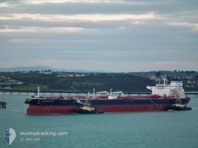
CLEAROCEAN AJAX
Tanker
Current Trip
CH YPG
| Time Travelled | 16 days |
|---|---|
| Remaining Time | --- |
| Distance Travelled | 4513.58 nm |
| Remaining Distance | --- |
| AVG Speed | 11.6 Knots |
| MAX Speed | 15.3 Knots |
| AVG Wind | 15.8 knots |
| MAX Wind | 31.9 knots |
| MIN Temp | 10.7°C / 51.26°F |
| MAX Temp | 27.1°C / 80.78°F |
| Draught | 12.8 m |
| Position Received | 32 m ago |
Current Position
| Longitude | 27.75681° |
|---|---|
| Latitude | 32.89490° |
| Status | Under way using engine |
| Speed | 12.8 Knots |
| Course | 105° |
| Area | Mediterranean Sea - Eastern Basin |
| Station | T-AIS |
| Position Received | 32 m ago |
Info
Information
The current position of CLEAROCEAN AJAX is in Mediterranean Sea - Eastern Basin with coordinates 32.89490° / 27.75681° as reported on 2024-06-21 20:03 by AIS to our vessel tracker app. The vessel's current speed is 12.8 Knots
The vessel CLEAROCEAN AJAX (IMO: 9850692, MMSI: 636019152) is a Tanker It's sailing under the flag of [LR] Liberia.
In this page you can find informations about the vessels current position, last detected port calls, and current voyage information. If the vessels is not in coverage by AIS you will find the latest position.
The current position of CLEAROCEAN AJAX is detected by our AIS receivers and we are not responsible for the reliability of the data. The last position was recorded while the vessel was in Coverage by the Ais receivers of our vessel tracking app.
The current draught of CLEAROCEAN AJAX as reported by AIS is 12.8 meters
Weather
| Temperature | 26.1°C / 78.98°F |
|---|---|
| Wind Speed | 7 knots |
| Direction | 316° NW |
| Pressure | 1007.4 hPa |
| Humidity | 79.2 % |
| Cloud Coverage | 1 % |
Featured Company
Last Port Calls
| Port | Arrival | Departure | Time In Port |
|---|---|---|---|
| 2024-06-03 17:41 | 2024-06-05 18:16 | 2 d | |
| 2024-05-25 17:59 | 2024-05-28 05:43 | 2 d | |
| 2024-04-13 15:27 | 2024-04-15 18:58 | 2 d | |
| 2024-04-10 07:45 | 2024-04-11 15:07 | 1 d |
Most Visited Ports (Last year)
| Port | Arrivals | |
|---|---|---|
| 4 | ||
| 3 | ||
| 2 | ||
| 2 | ||
| 2 | ||
| 1 |
Last Trips
| Origin | Departure | Destination | Arrival | Distance | |
|---|---|---|---|---|---|
| 2024-05-28 07:43 | 2024-06-03 20:41 | 2060.60 nm | |||
| 2024-04-16 02:58 | 2024-05-25 19:59 | 11609.26 nm | |||
| 2024-04-11 23:07 | 2024-04-13 23:27 | 39.30 nm | |||
| 2024-03-31 07:42 | 2024-04-10 15:45 | 1721.08 nm |
Events
| Time | Event | Details | Position / Dest | Info |
|---|---|---|---|---|
| 2024-06-21 20:09 | Status Changed | Default Under way using engine |
32.88829 / 27.78421
CH YPG
|
Speed: 12.8 kn Course: 105° |
| 2024-06-21 19:11 | Status Changed | Under way using engine Default |
32.94761 / 27.54502
CH YPG
|
Speed: 13.1 kn Course: 106° |
| 2024-06-21 19:11 | IN Coverage |
32.94761 / 27.54502
Mediterranean Sea - Eastern Basin
CH YPG
|
Speed: 13.1 kn Course: 106.3° |
|
| 2024-06-21 17:40 | Status Changed | Default Under way using engine |
33.04252 / 27.16531
CH YPG
|
Speed: 13.5 kn Course: 106° |
| 2024-06-21 17:37 | OUT of Coverage |
33.04648 / 27.14892
Mediterranean Sea - Eastern Basin
CH YPG
|
Speed: 13.5 kn Course: 106° |
|
| 2024-06-21 17:14 | Status Changed | Under way using engine Default |
33.06992 / 27.05338
CH YPG
|
Speed: 13.6 kn Course: 108° |
| 2024-06-21 16:45 | Status Changed | Default Under way using engine |
33.10233 / 26.92846
CH YPG
|
Speed: 14 kn Course: 107.1° |
| 2024-06-21 16:13 | Status Changed | Under way using engine Default |
33.13883 / 26.78328
CH YPG
|
Speed: 14 kn Course: 106° |
| 2024-06-21 15:57 | IN Coverage |
33.13794 / 26.78683
Mediterranean Sea - Eastern Basin
CH YPG
|
Speed: 13.9 kn Course: 106.5° |
|
| 2024-06-21 14:52 | OUT of Coverage |
33.22892 / 26.41994
Mediterranean Sea - Eastern Basin
CH YPG
|
Speed: 14.5 kn Course: 106.1° |