
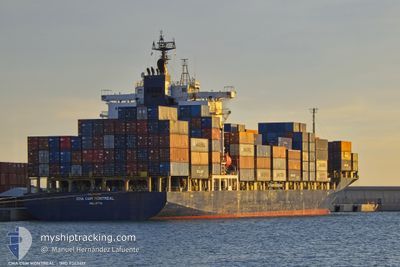
CMA CGM MONTREAL
Container Ship
Current Trip
| Time Travelled | 22 h, 28 mins |
|---|---|
| Remaining Time | --- |
| Distance Travelled | 320.53 nm |
| Remaining Distance | --- |
| AVG Speed | 14 Knots |
| MAX Speed | 15.1 Knots |
| AVG Wind | 10.9 knots |
| MAX Wind | 18.6 knots |
| MIN Temp | 25.9°C / 78.62°F |
| MAX Temp | 27.1°C / 80.78°F |
| Draught | 8 m |
| Position Received | Now |
Current Position
| Longitude | 29.34308° |
|---|---|
| Latitude | 35.31184° |
| Status | Under way using engine |
| Speed | 11.9 Knots |
| Course | 288.4° |
| Area | Mediterranean Sea - Eastern Basin |
| Station | T-AIS |
| Position Received | Now |
Info
Information
The current position of CMA CGM MONTREAL is in Mediterranean Sea - Eastern Basin with coordinates 35.31184° / 29.34308° as reported on 2024-06-30 02:24 by AIS to our vessel tracker app. The vessel's current speed is 11.9 Knots and is heading at the port of ALIAGA. The estimated time of arrival as calculated by vessel tracking app is 2024-07-01 12:00 LT
The vessel CMA CGM MONTREAL (IMO: 9363417, MMSI: 229846000) is a Container Ship that was built in 2007 ( 17 years old ). It's sailing under the flag of [MT] Malta.
In this page you can find informations about the vessels current position, last detected port calls, and current voyage information. If the vessels is not in coverage by AIS you will find the latest position.
The current position of CMA CGM MONTREAL is detected by our AIS receivers and we are not responsible for the reliability of the data. The last position was recorded while the vessel was in Coverage by the Ais receivers of our vessel tracking app.
The current draught of CMA CGM MONTREAL as reported by AIS is 8 meters
Weather
| Temperature | 26°C / 78.8°F |
|---|---|
| Wind Speed | 6 knots |
| Direction | 294° WNW |
| Pressure | 1002.2 hPa |
| Humidity | 77.8 % |
| Cloud Coverage | --- |
Featured Company
Last Port Calls
| Port | Arrival | Departure | Time In Port |
|---|---|---|---|
| 2024-06-28 13:12 | 2024-06-29 03:57 | 14 h | |
| 2024-06-27 11:18 | |||
| 2024-06-25 15:21 | 2024-06-26 15:21 | 23 h | |
| 2024-06-22 13:43 | 2024-06-24 04:31 | 1 d | |
| 2024-06-17 02:50 | 2024-06-18 07:16 | 1 d | |
| 2024-06-15 08:29 | 2024-06-16 12:09 | 1 d | |
| 2024-06-14 14:37 | 2024-06-15 00:50 | 10 h | |
| 2024-06-13 01:35 | 2024-06-14 06:02 | 1 d | |
| 2024-06-11 20:46 | 2024-06-12 16:49 | 20 h | |
| 2024-06-08 10:46 | 2024-06-09 16:23 | 1 d |
Last Trips
| Origin | Departure | Destination | Arrival | Distance | |
|---|---|---|---|---|---|
| 2024-06-26 17:21 | 2024-06-27 14:18 | 284.72 nm | |||
| 2024-06-24 07:31 | 2024-06-25 17:21 | 526.56 nm | |||
| 2024-06-18 09:16 | 2024-06-22 16:43 | 1026.17 nm | |||
| 2024-06-16 14:09 | 2024-06-17 04:50 | 71.73 nm | |||
| 2024-06-15 02:50 | 2024-06-15 10:29 | 73.51 nm | |||
| 2024-06-14 08:02 | 2024-06-14 16:37 | 107.94 nm | |||
| 2024-06-12 18:49 | 2024-06-13 03:35 | 103.47 nm | |||
| 2024-06-09 19:23 | 2024-06-11 22:46 | 776.62 nm | |||
| 2024-06-07 00:45 | 2024-06-08 13:46 | 260.83 nm | |||
| 2024-06-01 16:09 | 2024-06-05 12:19 | 690.57 nm |
Events
| Time | Event | Details | Position / Dest | Info |
|---|---|---|---|---|
| 2024-06-29 23:20 | Detected in Sea | Greek part of the Mediterranean Sea - Eastern Basin |
35.09652 / 30.11668
Mediterranean Sea - Eastern Basin
LB BEY>TR ALI
|
Speed: 14 kn Course: 287.6° |
| 2024-06-29 21:10 | Detected in Sea | Turkish part of the Mediterranean Sea - Eastern Basin |
34.94281 / 30.69879
Mediterranean Sea - Eastern Basin
LB BEY>TR ALI
|
Speed: 14.3 kn Course: 288.2° |
| 2024-06-29 19:25 | Status Changed | Under way using engine Default |
34.80932 / 31.20590
LB BEY>TR ALI
|
Speed: 14.6 kn Course: 289° |
| 2024-06-29 18:51 | Status Changed | Default Under way using engine |
34.76347 / 31.36883
LB BEY>TR ALI
|
Speed: 14.7 kn Course: 288.8° |
| 2024-06-29 18:22 | Status Changed | Under way using engine Default |
34.72489 / 31.50522
LB BEY>TR ALI
|
Speed: 14.5 kn Course: 289° |
| 2024-06-29 18:10 | Status Changed | Default Under way using engine |
34.71026 / 31.55780
LB BEY>TR ALI
|
Speed: 14.5 kn Course: 288.9° |
| 2024-06-29 17:33 | ETA Changed | 2024/07/01 12:00 2024/07/01 05:00 |
34.66146 / 31.73339
LB BEY>TR ALI
|
Speed: 14.6 kn Course: 288.7° |
| 2024-06-29 17:25 | Status Changed | Under way using engine Default |
34.65188 / 31.76731
LB BEY>TR ALI
|
Speed: 14.5 kn Course: 289° |
| 2024-06-29 17:10 | Status Changed | Default Under way using engine |
34.63130 / 31.83920
LB BEY>TR ALI
|
Speed: 14.5 kn Course: 289.5° |
| 2024-06-29 12:04 | IN Coverage |
34.29585 / 33.26444
Mediterranean Sea - Eastern Basin
LB BEY>TR ALI
|
Speed: 14.4 kn Course: 281.6° |