
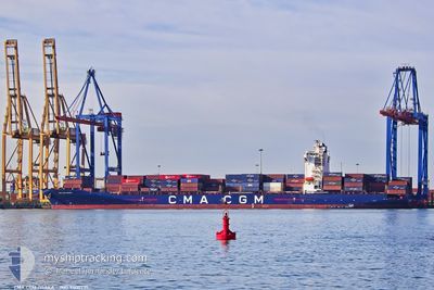
CMA CGM OSAKA
Container Ship
Current Trip
| Time Travelled | 5 h, 47 mins |
|---|---|
| Remaining Time | --- |
| Distance Travelled | 91.08 nm |
| Remaining Distance | --- |
| AVG Speed | 16.5 Knots |
| MAX Speed | 19.3 Knots |
| AVG Wind | 12.1 knots |
| MAX Wind | 19.3 knots |
| MIN Temp | 16.5°C / 61.7°F |
| MAX Temp | 18.5°C / 65.3°F |
| Draught | 10.5 m |
| Position Received | 1 m ago |
Current Position
| Longitude | 27.58116° |
|---|---|
| Latitude | 40.74721° |
| Status | Under way using engine |
| Speed | 19 Knots |
| Course | 245.2° |
| Area | Sea of Marmara |
| Station | T-AIS |
| Position Received | 1 m ago |
Info
Information
The current position of CMA CGM OSAKA is in Sea of Marmara with coordinates 40.74721° / 27.58116° as reported on 2024-05-19 11:15 by AIS to our vessel tracker app. The vessel's current speed is 19 Knots and is heading at the port of ALIAGA. The estimated time of arrival as calculated by vessel tracking app is 2024-05-20 01:00 LT
The vessel CMA CGM OSAKA (IMO: 9400291, MMSI: 256229000) is a Container Ship that was built in 2008 ( 16 years old ). It's sailing under the flag of [MT] Malta.
In this page you can find informations about the vessels current position, last detected port calls, and current voyage information. If the vessels is not in coverage by AIS you will find the latest position.
The current position of CMA CGM OSAKA is detected by our AIS receivers and we are not responsible for the reliability of the data. The last position was recorded while the vessel was in Coverage by the Ais receivers of our vessel tracking app.
The current draught of CMA CGM OSAKA as reported by AIS is 10.5 meters
Weather
| Temperature | 16.8°C / 62.24°F |
|---|---|
| Wind Speed | 11 knots |
| Direction | 60° ENE |
| Pressure | 1014.1 hPa |
| Humidity | 78.2 % |
| Cloud Coverage | 100 % |
Featured Company
Last Port Calls
| Port | Arrival | Departure | Time In Port |
|---|---|---|---|
| 2024-05-18 13:20 | 2024-05-19 05:29 | 16 h | |
| 2024-05-17 15:47 | 2024-05-18 09:23 | 17 h | |
| 2024-05-14 01:41 | 2024-05-16 15:44 | 2 d | |
| 2024-05-09 20:29 | 2024-05-10 19:51 | 23 h | |
| 2024-05-05 08:15 | 2024-05-06 18:55 | 1 d | |
| 2024-04-29 06:45 | 2024-04-30 03:19 | 20 h | |
| 2024-04-25 18:06 | 2024-04-27 02:15 | 1 d | |
| 2024-04-22 02:39 | 2024-04-23 22:57 | 1 d | |
| 2024-04-19 20:17 | 2024-04-20 17:15 | 20 h | |
| 2024-04-15 04:22 | 2024-04-17 12:36 | 2 d |
Most Visited Ports (Last year)
| Port | Arrivals | |
|---|---|---|
| 9 | ||
| 6 | ||
| 5 | ||
| 5 | ||
| 5 | ||
| 5 |
Last Trips
| Origin | Departure | Destination | Arrival | Distance | |
|---|---|---|---|---|---|
| 2024-05-18 12:23 | 2024-05-18 16:20 | 49.66 nm | |||
| 2024-05-16 18:44 | 2024-05-17 18:47 | 219.86 nm | |||
| 2024-05-10 22:51 | 2024-05-14 04:41 | 582.51 nm | |||
| 2024-05-06 20:55 | 2024-05-09 23:29 | 543.52 nm | |||
| 2024-04-30 05:19 | 2024-05-05 10:15 | 796.07 nm | |||
| 2024-04-27 03:15 | 2024-04-29 08:45 | 414.79 nm | |||
| 2024-04-23 23:57 | 2024-04-25 19:06 | 224.68 nm | |||
| 2024-04-20 19:15 | 2024-04-22 03:39 | 588.12 nm | |||
| 2024-04-17 14:36 | 2024-04-19 22:17 | 765.62 nm | |||
| 2024-04-12 22:23 | 2024-04-15 06:22 | 684.71 nm |
Events
| Time | Event | Details | Position / Dest | Info |
|---|---|---|---|---|
| 2024-05-19 08:44 | Status Changed | Under way using engine Default |
40.74934 / 28.50965
TRALI
|
Speed: 16.9 kn Course: 272° |
| 2024-05-19 08:37 | Status Changed | Default Under way using engine |
40.74874 / 28.55665
TRALI
|
Speed: 17 kn Course: 270.3° |
| 2024-05-19 08:30 | Status Changed | Under way using engine Default |
40.74839 / 28.59772
TRALI
|
Speed: 17 kn Course: 270° |
| 2024-05-19 08:24 | Status Changed | Default Under way using engine |
40.74815 / 28.63378
TRALI
|
Speed: 16.9 kn Course: 270.8° |
| 2024-05-19 07:06 | ETA Changed | 2024/05/20 01:00 2024/05/20 02:00 |
40.73499 / 29.10889
TRALI
|
Speed: 16.4 kn Course: 257.3° |
| 2024-05-19 05:36 | START Moving | 0.24 nm, South of DILISKELESI |
40.75955 / 29.53663
TRALI
|
Speed: 4.1 kn Course: 265° |
| 2024-05-19 05:32 | STOP Moving | 0.27 nm, South East of DILISKELESI |
40.75962 / 29.53957
TRALI
|
Speed: 0.3 kn Course: 275° |
| 2024-05-19 05:29 | PORT DEPARTURE |
|
40.76098 / 29.53667
TRALI
|
Speed: 3.6 kn Course: 332° |
| 2024-05-19 05:27 | START Moving |
40.76264 / 29.53553
[TR] DILISKELESI
|
Speed: 3.6 kn Course: 340° |
|
| 2024-05-19 05:24 | Status Changed | Under way using engine Moored |
40.76447 / 29.53464
[TR] DILISKELESI
|
Speed: 0.4 kn Course: 347° |