
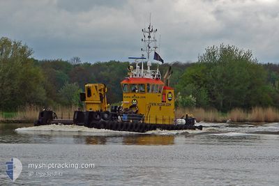
COASTAL BRUISER
Utility Vessel
Current Trip
NMDC BASE
| Time Travelled | --- |
|---|---|
| Remaining Time | --- |
| Distance Travelled | 1149.22 nm |
| Remaining Distance | --- |
| AVG Speed | 5.9 Knots |
| MAX Speed | 15.7 Knots |
| AVG Wind | 9.8 knots |
| MAX Wind | 24 knots |
| MIN Temp | 18.3°C / 64.94°F |
| MAX Temp | 26.6°C / 79.88°F |
| Draught | 2.4 m |
| Position Received | 1 h, 11 m ago |
Current Position
| Longitude | 54.56110° |
|---|---|
| Latitude | 24.71548° |
| Status | Under way using engine |
| Speed | 6.7 Knots |
| Course | 54.6° |
| Area | Persian Gulf |
| Station | T-AIS |
| Position Received | 1 h, 11 m ago |
Info
Information
The current position of COASTAL BRUISER is in Persian Gulf with coordinates 24.71548° / 54.56110° as reported on 2024-05-06 01:02 by AIS to our vessel tracker app. The vessel's current speed is 6.7 Knots
The vessel COASTAL BRUISER (IMO: 9479723, MMSI: 245972000) is a Utility Vessel that was built in 2008 ( 16 years old ). It's sailing under the flag of [NL] Netherlands.
In this page you can find informations about the vessels current position, last detected port calls, and current voyage information. If the vessels is not in coverage by AIS you will find the latest position.
The current position of COASTAL BRUISER is detected by our AIS receivers and we are not responsible for the reliability of the data. The last position was recorded while the vessel was in Coverage by the Ais receivers of our vessel tracking app.
The current draught of COASTAL BRUISER as reported by AIS is 2.4 meters
Weather
| Temperature | 27.6°C / 81.68°F |
|---|---|
| Wind Speed | 4 knots |
| Direction | 109° ESE |
| Pressure | 1007.9 hPa |
| Humidity | 71.6 % |
| Cloud Coverage | --- |
Featured Company
Last Port Calls
Last Trips
| Origin | Departure | Destination | Arrival | Distance |
|---|
Events
| Time | Event | Details | Position / Dest | Info |
|---|---|---|---|---|
| 2024-05-06 01:02 | OUT of Coverage |
24.71548 / 54.56110
Persian Gulf
|
Speed: 6.7 kn Course: 54.6° |
|
| 2024-05-06 00:15 | START Moving | 12.53 nm, South West of KHALIFA |
24.66880 / 54.49625
NMDC BASE
|
Speed: 4.4 kn Course: 52° |
| 2024-05-05 18:13 | STOP Moving | 12.64 nm, South West of KHALIFA |
24.66703 / 54.49515
NMDC BASE
|
Speed: 0.3 kn Course: 135° |
| 2024-05-05 18:07 | START Moving | 12.43 nm, South West of KHALIFA |
24.67053 / 54.49687
NMDC BASE
|
Speed: 3.1 kn Course: 165° |
| 2024-05-05 16:40 | STOP Moving | 12.47 nm, South West of KHALIFA |
24.67168 / 54.49477
NMDC BASE
|
Speed: 0.2 kn Course: 312° |
| 2024-05-05 16:35 | START Moving | 12.27 nm, South West of KHALIFA |
24.67155 / 54.49977
NMDC BASE
|
Speed: 6.3 kn Course: 225° |
| 2024-05-05 16:32 | STOP Moving | 12.16 nm, South West of KHALIFA |
24.67338 / 54.50082
NMDC BASE
|
Speed: 0.2 kn Course: 81° |
| 2024-05-05 16:31 | START Moving | 12.16 nm, South West of KHALIFA |
24.67360 / 54.50057
NMDC BASE
|
Speed: 3.1 kn Course: 130° |
| 2024-05-05 16:11 | STOP Moving | 12.12 nm, South West of KHALIFA |
24.67547 / 54.49967
NMDC BASE
|
Speed: 0.3 kn Course: 290° |
| 2024-05-05 15:25 | START Moving | 7.79 nm, South West of KHALIFA |
24.71802 / 54.56447
NMDC BASE
|
Speed: 6.5 kn Course: 222.9° |