
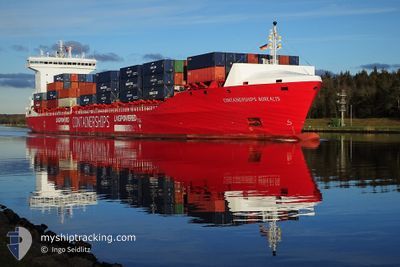
CONTSHIPS BOREALIS
Cargo A
Current Trip
| Time Travelled | 4 days |
|---|---|
| Remaining Time | 10 h, 14 mins |
| Distance Travelled | 1371.61 nm |
| Remaining Distance | 117.92 nm |
| AVG Speed | 14.5 Knots |
| MAX Speed | 17.6 Knots |
| AVG Wind | 14.7 knots |
| MAX Wind | 23 knots |
| MIN Temp | 8.2°C / 46.76°F |
| MAX Temp | 17.9°C / 64.22°F |
| Draught | 9 m |
| Position Received | Now |
Current Position
| Longitude | 1.83865° |
|---|---|
| Latitude | 55.50437° |
| Status | Under way using engine |
| Speed | 11.5 Knots |
| Course | 244.7° |
| Area | North Sea |
| Station | T-AIS |
| Position Received | Now |
Info
Information
The current position of CONTSHIPS BOREALIS is in North Sea with coordinates 55.50437° / 1.83865° as reported on 2024-05-19 08:57 by AIS to our vessel tracker app. The vessel's current speed is 11.5 Knots and is heading at the port of TEES. The estimated time of arrival as calculated by vessel tracking app is 2024-05-19 19:11 LT
The vessel CONTSHIPS BOREALIS (IMO: 9866249, MMSI: 210028000) is a Cargo A It's sailing under the flag of [CY] Cyprus.
In this page you can find informations about the vessels current position, last detected port calls, and current voyage information. If the vessels is not in coverage by AIS you will find the latest position.
The current position of CONTSHIPS BOREALIS is detected by our AIS receivers and we are not responsible for the reliability of the data. The last position was recorded while the vessel was in Coverage by the Ais receivers of our vessel tracking app.
The current draught of CONTSHIPS BOREALIS as reported by AIS is 9 meters
Weather
| Temperature | 12.2°C / 53.96°F |
|---|---|
| Wind Speed | 9 knots |
| Direction | 13° NNE |
| Pressure | 1016.5 hPa |
| Humidity | 79.3 % |
| Cloud Coverage | 6 % |
Featured Company
Last Port Calls
| Port | Arrival | Departure | Time In Port |
|---|---|---|---|
| 2024-05-14 06:26 | 2024-05-14 15:59 | 9 h | |
| 2024-05-13 02:53 | 2024-05-14 02:12 | 23 h | |
| 2024-05-11 01:01 | 2024-05-11 01:04 | 3 m | |
| 2024-05-08 21:16 | 2024-05-09 20:55 | 23 h | |
| 2024-05-08 20:51 | |||
| 2024-05-08 20:39 | |||
| 2024-05-07 14:45 | 2024-05-08 00:15 | 9 h | |
| 2024-05-05 22:14 | 2024-05-06 15:54 | 17 h | |
| 2024-04-30 14:21 | 2024-04-30 21:53 | 7 h | |
| 2024-04-29 08:40 | 2024-04-30 10:49 | 1 d |
Most Visited Ports (Last year)
| Port | Arrivals | |
|---|---|---|
| 16 | ||
| 14 | ||
| 13 | ||
| 12 | ||
| 12 | ||
| 11 |
Last Trips
| Origin | Departure | Destination | Arrival | Distance | |
|---|---|---|---|---|---|
| 2024-05-14 05:12 | 2024-05-14 09:26 | 46.86 nm | |||
| 2024-05-11 03:04 | 2024-05-13 05:53 | 648.74 nm | |||
| 2024-05-09 22:55 | 2024-05-11 03:01 | 328.59 nm | |||
| 2024-05-08 02:15 | 2024-05-08 23:16 | 112.93 nm | |||
| 2024-05-08 02:15 | 2024-05-08 22:51 | 112.89 nm | |||
| 2024-05-08 02:15 | 2024-05-08 22:39 | 112.61 nm | |||
| 2024-05-06 16:54 | 2024-05-07 16:45 | 290.28 nm | |||
| 2024-05-01 00:53 | 2024-05-05 23:14 | 1505.37 nm | |||
| 2024-04-30 13:49 | 2024-04-30 17:21 | 46.40 nm | |||
| 2024-04-26 12:18 | 2024-04-29 11:40 | 981.83 nm |
Events
| Time | Event | Details | Position / Dest | Info |
|---|---|---|---|---|
| 2024-05-19 03:56 | Detected in Sea | United Kingdom part of the North Sea |
55.91154 / 3.34485
North Sea
GBTEE
|
Speed: 11.1 kn Course: 244.3° |
| 2024-05-19 03:53 | Detected in Sea | German part of the North Sea |
55.91553 / 3.35968
North Sea
GBTEE
|
Speed: 11.1 kn Course: 244.4° |
| 2024-05-18 13:03 | ETA Changed | 2024/05/19 19:00 2024/05/19 12:00 |
57.25297 / 7.75471
GBTEE
|
Speed: 13.3 kn Course: 240.9° |
| 2024-05-18 11:58 | Detected in Sea | Danish part of the North Sea |
57.36967 / 8.14463
North Sea
GBTEE
|
Speed: 13.4 kn Course: 240.8° |
| 2024-05-18 05:01 | Change Sea Area | Danish part of the Skaggerak Danish part of the Kattegat |
57.79994 / 10.92422
Skaggerak
GBTEE
|
Speed: 14.4 kn Course: 317.6° |
| 2024-05-18 03:59 | Change Sea Area | Danish part of the Kattegat Swedish part of the Kattegat |
57.62004 / 11.23195
Kattegat
GBTEE
|
Speed: 14 kn Course: 316.2° |
| 2024-05-18 01:11 | Detected in Sea | Swedish part of the Kattegat |
57.05394 / 11.71702
Kattegat
GBTEE
|
Speed: 13.3 kn Course: 342.1° |
| 2024-05-17 14:20 | Change Sea Area | Danish part of the Kattegat Danish part of the Baltic Sea |
54.73768 / 10.78160
Kattegat
GBTEE
|
Speed: 15.6 kn Course: 19.3° |
| 2024-05-17 13:50 | Change Sea Area | Danish part of the Baltic Sea German part of the Baltic Sea |
54.63816 / 10.87722
Baltic Sea
GBTEE
|
Speed: 14.3 kn Course: 306.3° |
| 2024-05-17 12:44 | Detected in Sea | German part of the Baltic Sea |
54.57133 / 11.31562
Baltic Sea
GBTEE
|
Speed: 14.8 kn Course: 295.2° |