
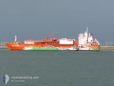
CORAL FRASERI
Lng Tanker
Current Trip
| Trip Time | 1 day |
|---|---|
| Trip Distance | 602.83 nm |
| AVG Speed | 13.3 Knots |
| MAX Speed | 15.2 Knots |
| Draught | 7.3 m |
| AVG Wind | 12.6 knots |
| MAX Wind | 23.8 knots |
| MIN Temp | 11.4°C / 52.52°F |
| MAX Temp | 16.6°C / 61.88°F |
| Position Received | 2 m ago |
Current Position
| Longitude | 4.33372° |
|---|---|
| Latitude | 51.24603° |
| Status | Moored |
| Speed | |
| Course | 135° |
| Area | North Sea |
| Station | T-AIS |
| Position Received | 2 m ago |
Info
Information
The current position of CORAL FRASERI is in North Sea with coordinates 51.24603° / 4.33372° as reported on 2024-06-01 06:01 by AIS to our vessel tracker app. The vessel's current speed is 0 Knots and is currently inside the port of ANTWERP.
The vessel CORAL FRASERI (IMO: 9378278, MMSI: 636022010) is a Lng Tanker that was built in 2010 ( 14 years old ). It's sailing under the flag of [LR] Liberia.
In this page you can find informations about the vessels current position, last detected port calls, and current voyage information. If the vessels is not in coverage by AIS you will find the latest position.
The current position of CORAL FRASERI is detected by our AIS receivers and we are not responsible for the reliability of the data. The last position was recorded while the vessel was in Coverage by the Ais receivers of our vessel tracking app.
The current draught of CORAL FRASERI as reported by AIS is 7.3 meters
Weather
| Temperature | 14°C / 57.2°F |
|---|---|
| Wind Speed | 10 knots |
| Direction | 348° NNW |
| Pressure | 1016.5 hPa |
| Humidity | 94.7 % |
| Cloud Coverage | 100 % |
Featured Company
Last Port Calls
| Port | Arrival | Departure | Time In Port |
|---|---|---|---|
| 2024-05-30 16:08 | |||
| 2024-05-27 18:45 | 2024-05-28 19:28 | 1 d | |
| 2024-05-20 14:08 | 2024-05-22 17:22 | 2 d | |
| 2024-05-17 13:57 | 2024-05-20 11:33 | 2 d | |
| 2024-05-14 20:45 | 2024-05-16 09:03 | 1 d | |
| 2024-05-11 12:26 | 2024-05-13 03:28 | 1 d | |
| 2024-05-08 07:17 | 2024-05-09 13:45 | 1 d | |
| 2024-04-29 07:24 | 2024-04-30 01:18 | 17 h | |
| 2024-04-25 19:03 | 2024-04-26 18:25 | 23 h | |
| 2024-04-03 18:06 | 2024-04-25 14:44 | 21 d |
Most Visited Ports (Last year)
| Port | Arrivals | |
|---|---|---|
| 47 | ||
| 3 | ||
| 2 | ||
| 2 | ||
| 2 | ||
| 1 |
Last Trips
| Origin | Departure | Destination | Arrival | Distance | |
|---|---|---|---|---|---|
| 2024-05-28 21:28 | 2024-05-30 18:08 | 602.83 nm | |||
| 2024-05-22 19:22 | 2024-05-27 20:45 | 556.48 nm | |||
| 2024-05-20 13:33 | 2024-05-20 16:08 | 21.35 nm | |||
| 2024-05-16 10:03 | 2024-05-17 15:57 | 392.14 nm | |||
| 2024-05-13 05:28 | 2024-05-14 21:45 | 461.53 nm | |||
| 2024-05-09 14:45 | 2024-05-11 14:26 | 477.34 nm | |||
| 2024-04-30 02:18 | 2024-05-08 08:17 | 96.63 nm | |||
| 2024-04-26 20:25 | 2024-04-29 08:24 | 433.53 nm | |||
| 2024-04-25 16:44 | 2024-04-25 21:03 | 53.37 nm | |||
| 2024-04-01 14:29 | 2024-04-03 20:06 | 554.84 nm |
Events
| Time | Event | Details | Position / Dest | Info |
|---|---|---|---|---|
| 2024-06-01 00:01 | ETA Changed | 2025/05/30 10:00 2024/05/30 10:00 |
51.24607 / 4.33371
[BE] ANTWERP
|
Speed: Course: 135° |
| 2024-05-30 17:31 | Status Changed | Moored Under way using engine |
51.24605 / 4.33374
[BE] ANTWERP
|
Speed: Course: 135° |
| 2024-05-30 17:20 | STOP Moving |
51.24611 / 4.33375
[BE] ANTWERP
|
Speed: 0.3 kn Course: 133° |
|
| 2024-05-30 16:08 | PORT ARRIVAL |
|
51.36600 / 4.21996
[BE] ANTWERP
|
Speed: 15 kn Course: 168.8° |
| 2024-05-30 12:53 | Change Sea Area | Dutch part of the North Sea Belgian part of the North Sea |
51.40409 / 3.33976
North Sea
BE ZWL
|
Speed: 13.2 kn Course: 89.8° |
| 2024-05-30 11:20 | Change Sea Area | Belgian part of the North Sea Dutch part of the North Sea |
51.53325 / 3.09861
North Sea
BE ZWL
|
Speed: 14.8 kn Course: 220.1° |
| 2024-05-30 08:49 | ETA Changed | 2024/05/30 10:00 2024/05/30 09:00 |
51.99363 / 3.32348
BE ZWL
|
Speed: 13.3 kn Course: 188° |
| 2024-05-30 08:24 | Change Sea Area | Dutch part of the North Sea Danish part of the North Sea |
52.08192 / 3.34299
North Sea
BE ZWL
|
Speed: 13.3 kn Course: 183.7° |
| 2024-05-30 08:24 | Status Changed | Under way using engine Default |
52.08192 / 3.34299
BE ZWL
|
Speed: 13.4 kn Course: 176° |
| 2024-05-30 08:14 | IN Coverage |
52.08192 / 3.34299
North Sea
BE ZWL
|
Speed: 13.3 kn Course: 183.7° |