
CORRENTE
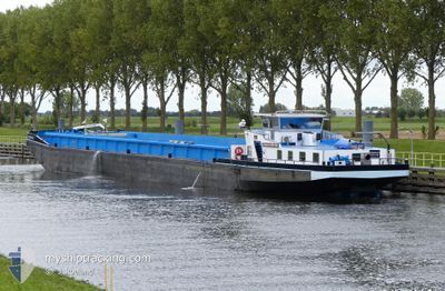
Cargo
Current Trip
HEEL
| Time Travelled | 3 days |
|---|---|
| Remaining Time | --- |
| Distance Travelled | 148.10 nm |
| Remaining Distance | --- |
| AVG Speed | 7.8 Knots |
| MAX Speed | 9.6 Knots |
| AVG Wind | 6.1 knots |
| MAX Wind | 19 knots |
| MIN Temp | 11.7°C / 53.06°F |
| MAX Temp | 19.9°C / 67.82°F |
| Draught | 3 m |
| Position Received | 9 m ago |
Current Position
| Longitude | 5.91199° |
|---|---|
| Latitude | 51.16789° |
| Status | Moored |
| Speed | |
| Course | --- |
| Area | North Sea |
| Station | T-AIS |
| Position Received | 9 m ago |
Info
Information
The current position of CORRENTE is in North Sea with coordinates 51.16789° / 5.91199° as reported on 2024-06-18 13:52 by AIS to our vessel tracker app. The vessel's current speed is 0 Knots
The vessel CORRENTE (MMSI: 244830231) is a Cargo It's sailing under the flag of [NL] Netherlands.
In this page you can find informations about the vessels current position, last detected port calls, and current voyage information. If the vessels is not in coverage by AIS you will find the latest position.
The current position of CORRENTE is detected by our AIS receivers and we are not responsible for the reliability of the data. The last position was recorded while the vessel was in Coverage by the Ais receivers of our vessel tracking app.
The current draught of CORRENTE as reported by AIS is 3 meters
Weather
| Temperature | 16.7°C / 62.06°F |
|---|---|
| Wind Speed | 1 knots |
| Direction | 264° W |
| Pressure | 1012 hPa |
| Humidity | 96.2 % |
| Cloud Coverage | 100 % |
Featured Company
Last Port Calls
| Port | Arrival | Departure | Time In Port |
|---|---|---|---|
| 2024-06-15 04:34 | 2024-06-15 06:49 | 2 h | |
| 2024-06-14 14:37 | 2024-06-14 15:00 | 23 m | |
| 2024-06-13 20:27 | 2024-06-14 09:06 | 12 h | |
| 2024-06-13 15:13 | 2024-06-13 15:49 | 36 m | |
| 2024-06-13 11:09 | 2024-06-13 11:21 | 12 m | |
| 2024-06-12 14:25 | 2024-06-12 15:40 | 1 h | |
| 2024-06-11 07:01 | 2024-06-12 09:48 | 1 d | |
| 2024-06-10 08:41 | 2024-06-10 11:23 | 2 h | |
| 2024-06-10 00:35 | 2024-06-10 01:02 | 26 m | |
| 2024-06-09 19:44 | 2024-06-09 20:26 | 41 m |
Most Visited Ports (Last year)
| Port | Arrivals | |
|---|---|---|
| 12 | ||
| 11 | ||
| 11 | ||
| 9 | ||
| 8 | ||
| 7 |
Last Trips
| Origin | Departure | Destination | Arrival | Distance | |
|---|---|---|---|---|---|
| 2024-06-14 17:00 | 2024-06-15 06:34 | 65.94 nm | |||
| 2024-06-14 11:06 | 2024-06-14 16:37 | 38.09 nm | |||
| 2024-06-13 17:49 | 2024-06-13 22:27 | 36.82 nm | |||
| 2024-06-13 13:21 | 2024-06-13 17:13 | 29.26 nm | |||
| 2024-06-12 17:40 | 2024-06-13 13:09 | 125.50 nm | |||
| 2024-06-12 11:48 | 2024-06-12 16:25 | 24.81 nm | |||
| 2024-06-10 13:23 | 2024-06-11 09:01 | 124.18 nm | |||
| 2024-06-10 03:02 | 2024-06-10 10:41 | 13.05 nm | |||
| 2024-06-09 22:26 | 2024-06-10 02:35 | 1.33 nm | |||
| 2024-06-09 18:29 | 2024-06-09 21:44 | 1.33 nm |
Events
| Time | Event | Details | Position / Dest | Info |
|---|---|---|---|---|
| 2024-06-18 12:02 | Status Changed | Moored Under way using engine |
51.16795 / 5.91207
HEEL
|
Speed: Course: 511° |
| 2024-06-18 11:39 | Status Changed | Under way using engine Moored |
51.16866 / 5.91407
HEEL
|
Speed: Course: 511° |
| 2024-06-18 10:22 | Status Changed | Moored Under way using engine |
51.16844 / 5.91453
HEEL
|
Speed: Course: 511° |
| 2024-06-18 09:49 | STOP Moving | 1.61 nm, South West of OOLDERHUUSKE |
51.17560 / 5.91947
HEEL
|
Speed: Course: 511° |
| 2024-06-18 09:19 | IN Coverage |
51.19844 / 5.94600
North Sea
HEEL
|
Speed: 7.1 kn Course: 227.3° |
|
| 2024-06-18 05:56 | OUT of Coverage |
51.44836 / 6.15970
North Sea
HEEL
|
Speed: 7.4 kn Course: 210.2° |
|
| 2024-06-18 05:56 | IN Coverage |
51.44836 / 6.15970
North Sea
HEEL
|
Speed: 7.4 kn Course: 210.2° |
|
| 2024-06-18 04:52 | OUT of Coverage |
51.54726 / 6.09121
North Sea
HEEL
|
Speed: 7.4 kn Course: 85.9° |
|
| 2024-06-18 03:52 | START Moving | 2.2 nm, South East of BOXMEER |
51.63794 / 5.98872
HEEL
|
Speed: 5.8 kn Course: 119.1° |
| 2024-06-17 20:37 | STOP Moving | 2.06 nm, South East of BOXMEER |
51.63950 / 5.98549
HEEL
|
Speed: Course: 511° |