
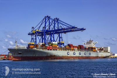
COSCO PHILIPPINES
Container Ship
Current Trip
PAPCN
| Time Travelled | 26 days |
|---|---|
| Remaining Time | --- |
| Distance Travelled | 10818.58 nm |
| Remaining Distance | --- |
| AVG Speed | 17.4 Knots |
| MAX Speed | 17.4 Knots |
| AVG Wind | 12.3 knots |
| MAX Wind | 37.9 knots |
| MIN Temp | 13.1°C / 55.58°F |
| MAX Temp | 30.6°C / 87.08°F |
| Draught | 12.7 m |
| Position Received | 3 d ago |
Current Position
| Longitude | -79.98128° |
|---|---|
| Latitude | 9.75073° |
| Status | Under way using engine |
| Speed | 18 Knots |
| Course | 352° |
| Area | Caribbean Sea |
| Station | T-AIS |
| Position Received | 3 d ago |
Info
Information
The current position of COSCO PHILIPPINES is in Caribbean Sea with coordinates 9.75073° / -79.98128° as reported on 2024-06-17 20:05 by AIS to our vessel tracker app. The vessel's current speed is 18 Knots
The vessel COSCO PHILIPPINES (IMO: 9448762, MMSI: 477738200) is a Container Ship that was built in 2010 ( 14 years old ). It's sailing under the flag of [HK] Hong Kong.
In this page you can find informations about the vessels current position, last detected port calls, and current voyage information. If the vessels is not in coverage by AIS you will find the latest position.
The current position of COSCO PHILIPPINES is detected by our AIS receivers and we are not responsible for the reliability of the data. The last position was recorded while the vessel was in Coverage by the Ais receivers of our vessel tracking app.
The current draught of COSCO PHILIPPINES as reported by AIS is 12.7 meters
Weather
| Temperature | 27.9°C / 82.22°F |
|---|---|
| Wind Speed | 18 knots |
| Direction | 94° E |
| Pressure | 1017.8 hPa |
| Humidity | 83.6 % |
| Cloud Coverage | 26 % |
Featured Company
Last Port Calls
| Port | Arrival | Departure | Time In Port |
|---|---|---|---|
| 2024-05-25 05:32 | 2024-05-25 18:56 | 13 h | |
| 2024-05-19 14:00 | 2024-05-20 14:24 | 1 d | |
| 2024-05-17 22:56 | 2024-05-18 07:48 | 8 h | |
| 2024-04-26 12:46 | 2024-04-30 13:19 | 4 d | |
| 2024-04-12 07:54 | 2024-04-12 23:06 | 15 h | |
| 2024-04-09 10:17 | 2024-04-10 10:14 | 23 h | |
| 2024-04-06 23:40 | 2024-04-08 01:09 | 1 d | |
| 2024-04-03 22:13 | 2024-04-05 02:08 | 1 d |
Last Trips
| Origin | Departure | Destination | Arrival | Distance | |
|---|---|---|---|---|---|
| 2024-05-20 22:24 | 2024-05-25 13:32 | 1046.03 nm | |||
| 2024-05-18 15:48 | 2024-05-19 22:00 | 199.02 nm | |||
| 2024-04-30 06:19 | 2024-05-18 06:56 | 5804.31 nm | |||
| 2024-04-13 07:06 | 2024-04-26 05:46 | 5787.85 nm | |||
| 2024-04-10 18:14 | 2024-04-12 15:54 | 479.78 nm | |||
| 2024-04-08 09:09 | 2024-04-09 18:17 | 449.46 nm | |||
| 2024-04-05 10:08 | 2024-04-07 07:40 | 761.35 nm | |||
| 2024-03-09 10:16 | 2024-04-04 06:13 | 10243.89 nm |
Events
| Time | Event | Details | Position / Dest | Info |
|---|---|---|---|---|
| 2024-06-17 20:13 | Status Changed | Default Under way using engine |
9.79274 / -79.98700
PAPCN
|
Speed: 18 kn Course: 352° |
| 2024-06-17 20:05 | OUT of Coverage |
9.75073 / -79.98128
Caribbean Sea
|
Speed: 18 kn Course: 352° |
|
| 2024-06-17 20:01 | Status Changed | Under way using engine Default |
9.72686 / -79.97795
PAPCN
|
Speed: 18.4 kn Course: 352° |
| 2024-06-17 19:46 | Status Changed | Default Under way using engine |
9.65701 / -79.96243
PAPCN
|
Speed: 18 kn Course: 341° |
| 2024-06-17 19:42 | Change Sea Area | Panamanian part of the Caribbean Sea Mexican part of the North Pacific Ocean |
9.63616 / -79.95551
Caribbean Sea
|
Speed: 18 kn Course: 341° |
| 2024-06-17 19:42 | Status Changed | Under way using engine Default |
9.63616 / -79.95551
PAPCN
|
Speed: 18.2 kn Course: 342° |
| 2024-06-17 19:23 | IN Coverage |
9.63616 / -79.95551
Caribbean Sea
|
Speed: 18 kn Course: 341° |
|
| 2024-06-17 17:59 | START Moving | 3.81 nm, South of CRISTOBAL |
9.28271 / -79.91400
PAPCN
|
Speed: 4 kn Course: 356° |
| 2024-06-17 14:51 | STOP Moving | 5.58 nm, South of CRISTOBAL |
9.25289 / -79.90800
PAPCN
|
Speed: 0.3 kn Course: 353° |
| 2024-06-17 10:51 | START Moving | 2.59 nm, North West of RODMAN |
8.99204 / -79.59723
PAPCN
|
Speed: 4.7 kn Course: 322° |