
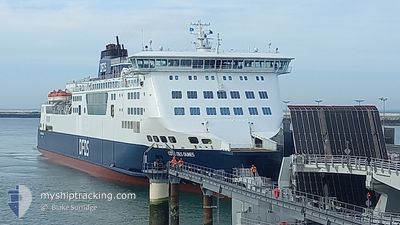
COTE DES DUNES
Ro-Ro/Passenger Ship
Current Trip
CALAIS DOVER CALAIS
| Time Travelled | 6 h, 43 mins |
|---|---|
| Remaining Time | --- |
| Distance Travelled | 22.89 nm |
| Remaining Distance | --- |
| AVG Speed | 11.8 Knots |
| MAX Speed | 14.9 Knots |
| AVG Wind | 23.3 knots |
| MAX Wind | 24 knots |
| MIN Temp | 13.8°C / 56.84°F |
| MAX Temp | 14.2°C / 57.56°F |
| Draught | 6 m |
| Position Received | 1 m ago |
Current Position
| Longitude | 1.87120° |
|---|---|
| Latitude | 50.97652° |
| Status | Under way using engine |
| Speed | |
| Course | 101° |
| Area | North Sea |
| Station | T-AIS |
| Position Received | 1 m ago |
Info
Information
The current position of COTE DES DUNES is in North Sea with coordinates 50.97652° / 1.87120° as reported on 2024-05-29 01:18 by AIS to our vessel tracker app. The vessel's current speed is 0 Knots
The vessel COTE DES DUNES (IMO: 9232527, MMSI: 227022800) is a Ro-Ro/Passenger Ship that was built in 2001 ( 23 years old ). It's sailing under the flag of [FR] France.
In this page you can find informations about the vessels current position, last detected port calls, and current voyage information. If the vessels is not in coverage by AIS you will find the latest position.
The current position of COTE DES DUNES is detected by our AIS receivers and we are not responsible for the reliability of the data. The last position was recorded while the vessel was in Coverage by the Ais receivers of our vessel tracking app.
The current draught of COTE DES DUNES as reported by AIS is 6 meters
Weather
| Temperature | 13.7°C / 56.66°F |
|---|---|
| Wind Speed | 23 knots |
| Direction | 236° SW |
| Pressure | 1010.1 hPa |
| Humidity | 96.5 % |
| Cloud Coverage | 100 % |
Featured Company
Last Port Calls
| Port | Arrival | Departure | Time In Port |
|---|---|---|---|
| 2024-05-28 17:39 | 2024-05-28 18:36 | 57 m | |
| 2024-05-28 12:24 | 2024-05-28 13:31 | 1 h | |
| 2024-05-28 07:04 | 2024-05-28 08:07 | 1 h | |
| 2024-05-27 17:37 | 2024-05-27 18:41 | 1 h | |
| 2024-05-27 12:25 | 2024-05-27 13:26 | 1 h | |
| 2024-05-27 07:11 | 2024-05-27 08:17 | 1 h | |
| 2024-05-26 20:21 | 2024-05-27 05:49 | 9 h | |
| 2024-05-26 17:39 | 2024-05-26 18:47 | 1 h | |
| 2024-05-26 12:23 | 2024-05-26 13:28 | 1 h | |
| 2024-05-26 07:13 | 2024-05-26 08:24 | 1 h |
Last Trips
| Origin | Departure | Destination | Arrival | Distance | |
|---|---|---|---|---|---|
| 2024-05-28 14:31 | 2024-05-28 18:39 | 46.20 nm | |||
| 2024-05-28 09:07 | 2024-05-28 13:24 | 46.35 nm | |||
| 2024-05-27 19:41 | 2024-05-28 08:04 | 45.89 nm | |||
| 2024-05-27 14:26 | 2024-05-27 18:37 | 45.96 nm | |||
| 2024-05-27 09:17 | 2024-05-27 13:25 | 46.13 nm | |||
| 2024-05-27 07:49 | 2024-05-27 08:11 | 22.14 nm | |||
| 2024-05-26 19:47 | 2024-05-26 22:21 | 21.89 nm | |||
| 2024-05-26 14:28 | 2024-05-26 18:39 | 46.39 nm | |||
| 2024-05-26 09:24 | 2024-05-26 13:23 | 46.80 nm | |||
| 2024-05-26 07:44 | 2024-05-26 08:13 | 22.28 nm |
Events
| Time | Event | Details | Position / Dest | Info |
|---|---|---|---|---|
| 2024-05-28 20:24 | STOP Moving | 0.91 nm, North East of CALAIS |
50.97653 / 1.87102
CALAIS DOVER CALAIS
|
Speed: 0.2 kn Course: 101° |
| 2024-05-28 19:41 | Change Sea Area | French part of the North Sea French part of the English Channel |
50.97802 / 1.65933
North Sea
|
Speed: 13 kn Course: 113.2° |
| 2024-05-28 19:17 | Detected in Sea | French part of the English Channel |
51.02508 / 1.54060
English Channel
|
Speed: 13.3 kn Course: 129.4° |
| 2024-05-28 18:36 | PORT DEPARTURE |
|
51.12018 / 1.34643
CALAIS DOVER CALAIS
|
Speed: 11 kn Course: 115° |
| 2024-05-28 18:35 | START Moving |
51.12280 / 1.34012
[GB] DOVER
|
Speed: 7.3 kn Course: 160° |
|
| 2024-05-28 17:50 | STOP Moving |
51.12545 / 1.33890
[GB] DOVER
|
Speed: Course: 161° |
|
| 2024-05-28 17:39 | PORT ARRIVAL |
|
51.12148 / 1.34258
[GB] DOVER
|
Speed: 10.9 kn Course: 290° |
| 2024-05-28 17:29 | Change Sea Area | United Kingdom part of the English Channel United Kingdom part of the North Sea |
51.11313 / 1.40437
English Channel
|
Speed: 16 kn Course: 294.9° |
| 2024-05-28 16:59 | Change Sea Area | United Kingdom part of the North Sea French part of the North Sea |
51.05720 / 1.59198
North Sea
|
Speed: 16.1 kn Course: 310.8° |
| 2024-05-28 16:09 | START Moving | 0.85 nm, North East of CALAIS |
50.97748 / 1.86812
CALAIS DOVER CALAIS
|
Speed: 7.1 kn Course: 296.5° |