
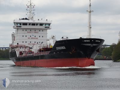
COVADONGA
Oil/Chemical Tanker
Current Trip
| Time Travelled | 2 days |
|---|---|
| Remaining Time | 38 mins |
| Distance Travelled | 738.12 nm |
| Remaining Distance | 14.00 nm |
| AVG Speed | 13.3 Knots |
| MAX Speed | 16.3 Knots |
| AVG Wind | 16.2 knots |
| MAX Wind | 20 knots |
| MIN Temp | 12.2°C / 53.96°F |
| MAX Temp | 15.9°C / 60.62°F |
| Draught | 5.9 m |
| Position Received | 1 m ago |
Current Position
| Longitude | 3.79998° |
|---|---|
| Latitude | 51.95229° |
| Status | At anchor |
| Speed | 0.4 Knots |
| Course | 276° |
| Area | North Sea |
| Station | T-AIS |
| Position Received | 1 m ago |
Info
Information
The current position of COVADONGA is in North Sea with coordinates 51.95229° / 3.79998° as reported on 2024-05-28 01:40 by AIS to our vessel tracker app. The vessel's current speed is 0.4 Knots and is heading at the port of ROTTERDAM. The estimated time of arrival as calculated by vessel tracking app is 2024-05-28 02:19 LT
The vessel COVADONGA (IMO: 9300489, MMSI: 255803540) is a Oil/Chemical Tanker that was built in 2005 ( 19 years old ). It's sailing under the flag of [PT] Portugal.
In this page you can find informations about the vessels current position, last detected port calls, and current voyage information. If the vessels is not in coverage by AIS you will find the latest position.
The current position of COVADONGA is detected by our AIS receivers and we are not responsible for the reliability of the data. The last position was recorded while the vessel was in Coverage by the Ais receivers of our vessel tracking app.
The current draught of COVADONGA as reported by AIS is 5.9 meters
Weather
| Temperature | 13.4°C / 56.12°F |
|---|---|
| Wind Speed | 14 knots |
| Direction | 236° SW |
| Pressure | 1016.6 hPa |
| Humidity | 76.2 % |
| Cloud Coverage | 64 % |
Featured Company
Last Port Calls
| Port | Arrival | Departure | Time In Port |
|---|---|---|---|
| 2024-05-23 21:46 | 2024-05-25 17:46 | 1 d | |
| 2024-05-18 09:12 | 2024-05-19 09:11 | 23 h | |
| 2024-05-12 04:24 | 2024-05-13 17:46 | 1 d | |
| 2024-05-03 11:57 | 2024-05-03 13:04 | 1 h | |
| 2024-05-02 07:24 | 2024-05-02 08:00 | 36 m | |
| 2024-04-27 14:56 | 2024-04-29 08:55 | 1 d | |
| 2024-04-27 05:47 | 2024-04-27 06:28 | 41 m | |
| 2024-04-25 20:55 | 2024-04-25 22:10 | 1 h | |
| 2024-04-13 16:00 | 2024-04-15 17:33 | 2 d | |
| 2024-04-05 04:56 | 2024-04-05 06:05 | 1 h |
Last Trips
| Origin | Departure | Destination | Arrival | Distance | |
|---|---|---|---|---|---|
| 2024-05-19 11:11 | 2024-05-23 23:46 | 1273.19 nm | |||
| 2024-05-13 19:46 | 2024-05-18 11:12 | 1291.86 nm | |||
| 2024-05-03 16:04 | 2024-05-12 06:24 | 2607.50 nm | |||
| 2024-05-02 11:00 | 2024-05-03 14:57 | 255.65 nm | |||
| 2024-04-29 11:55 | 2024-05-02 10:24 | 67.61 nm | |||
| 2024-04-27 09:28 | 2024-04-27 17:56 | 68.87 nm | |||
| 2024-04-26 01:10 | 2024-04-27 08:47 | 246.79 nm | |||
| 2024-04-15 19:33 | 2024-04-25 23:55 | 2714.83 nm | |||
| 2024-04-05 09:05 | 2024-04-13 18:00 | 2592.01 nm | |||
| 2024-04-02 15:23 | 2024-04-05 07:56 | 308.17 nm |
Events
| Time | Event | Details | Position / Dest | Info |
|---|---|---|---|---|
| 2024-05-28 01:37 | Status Changed | At anchor Under way using engine |
51.95196 / 3.79922
ROTTERDAM
|
Speed: 0.1 kn Course: 305° |
| 2024-05-28 01:36 | Status Changed | Under way using engine At anchor |
51.95194 / 3.79920
ROTTERDAM
|
Speed: 0.2 kn Course: 305° |
| 2024-05-28 01:35 | Status Changed | At anchor Under way using engine |
51.95198 / 3.79926
ROTTERDAM
|
Speed: 0.2 kn Course: 305° |
| 2024-05-28 01:35 | Status Changed | Under way using engine At anchor |
51.95192 / 3.79917
ROTTERDAM
|
Speed: 0.2 kn Course: 305° |
| 2024-05-28 01:34 | Status Changed | At anchor Under way using engine |
51.95196 / 3.79922
ROTTERDAM
|
Speed: 0.1 kn Course: 305° |
| 2024-05-28 01:19 | STOP Moving | 10.1 nm, West of MAASVLAKTE - ROTTERDAM |
51.95243 / 3.79752
ROTTERDAM
|
Speed: 0.3 kn Course: 160° |
| 2024-05-27 21:44 | ETA Changed | 2024/05/28 01:00 2024/05/28 00:00 |
51.79858 / 2.75044
ROTTERDAM
|
Speed: 12.5 kn Course: 65.3° |
| 2024-05-27 21:35 | Change Sea Area | Dutch part of the North Sea Belgian part of the North Sea |
51.78510 / 2.70155
North Sea
ROTTERDAM
|
Speed: 12.4 kn Course: 66.4° |
| 2024-05-27 19:47 | Change Sea Area | Belgian part of the North Sea French part of the North Sea |
51.49511 / 2.28496
North Sea
ROTTERDAM
|
Speed: 13.3 kn Course: 40.2° |
| 2024-05-27 16:56 | Change Sea Area | French part of the North Sea French part of the English Channel |
51.01420 / 1.61129
North Sea
ROTTERDAM
|
Speed: 15.4 kn Course: 43.3° |