
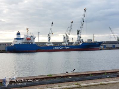
CROWN JADE
Reefer
Current Trip
| Time Travelled | 5 days |
|---|---|
| Remaining Time | --- |
| Distance Travelled | 2590.60 nm |
| Remaining Distance | --- |
| AVG Speed | 17.9 Knots |
| MAX Speed | 20.4 Knots |
| AVG Wind | 10.3 knots |
| MAX Wind | 23 knots |
| MIN Temp | 8.5°C / 47.3°F |
| MAX Temp | 16.5°C / 61.7°F |
| Draught | 6.6 m |
| Position Received | 1 d ago |
Current Position
| Longitude | -5.61454° |
|---|---|
| Latitude | 48.97197° |
| Status | Under way using engine |
| Speed | 17.3 Knots |
| Course | 240.8° |
| Area | Celtic Sea |
| Station | T-AIS |
| Position Received | 1 d ago |
Info
Information
The current position of CROWN JADE is in Celtic Sea with coordinates 48.97197° / -5.61454° as reported on 2024-05-21 14:18 by AIS to our vessel tracker app. The vessel's current speed is 17.3 Knots and is heading at the port of CRISTOBAL. The estimated time of arrival as calculated by vessel tracking app is 2024-06-01 17:00 LT
The vessel CROWN JADE (IMO: 9128051, MMSI: 311000791) is a Reefer that was built in 1997 ( 27 years old ). It's sailing under the flag of [BS] Bahamas.
In this page you can find informations about the vessels current position, last detected port calls, and current voyage information. If the vessels is not in coverage by AIS you will find the latest position.
The current position of CROWN JADE is detected by our AIS receivers and we are not responsible for the reliability of the data. The last position was recorded while the vessel was in Coverage by the Ais receivers of our vessel tracking app.
The current draught of CROWN JADE as reported by AIS is 6.6 meters
Weather
| Temperature | 14.5°C / 58.1°F |
|---|---|
| Wind Speed | 10 knots |
| Direction | 143° SE |
| Pressure | 1024.1 hPa |
| Humidity | 70 % |
| Cloud Coverage | 98 % |
Featured Company
Last Port Calls
| Port | Arrival | Departure | Time In Port |
|---|---|---|---|
| 2024-05-12 03:20 | 2024-05-17 08:20 | 5 d | |
| 2024-03-22 04:32 | 2024-03-26 19:58 | 4 d | |
| 2024-03-03 12:39 |
Last Trips
| Origin | Departure | Destination | Arrival | Distance | |
|---|---|---|---|---|---|
| 2024-03-26 22:58 | 2024-05-12 06:20 | 12582.42 nm | |||
| 2024-03-03 14:39 | 2024-03-22 07:32 | 7622.52 nm |
Events
| Time | Event | Details | Position / Dest | Info |
|---|---|---|---|---|
| 2024-05-21 14:20 | Status Changed | Default Under way using engine |
48.96667 / -5.62667
PACTB
|
Speed: 17.3 kn Course: 240.8° |
| 2024-05-21 14:18 | OUT of Coverage |
48.97197 / -5.61454
Celtic Sea
PACTB
|
Speed: 17.3 kn Course: 240.8° |
|
| 2024-05-21 13:43 | Status Changed | Under way using engine Default |
49.05664 / -5.39490
PACTB
|
Speed: 17.2 kn Course: 237° |
| 2024-05-21 13:39 | Status Changed | Default Under way using engine |
49.06771 / -5.36811
PACTB
|
Speed: 17.3 kn Course: 238.1° |
| 2024-05-21 13:31 | Detected in Sea | French part of the Celtic Sea |
49.08799 / -5.31988
Celtic Sea
PACTB
|
Speed: 17.3 kn Course: 237.8° |
| 2024-05-21 13:29 | Status Changed | Under way using engine Default |
49.09175 / -5.31076
PACTB
|
Speed: 17.3 kn Course: 237° |
| 2024-05-21 13:29 | IN Coverage |
49.08799 / -5.31988
Celtic Sea
PACTB
|
Speed: 17.3 kn Course: 237.8° |
|
| 2024-05-21 12:11 | Status Changed | Default Under way using engine |
49.29315 / -4.80475
PACTB
|
Speed: 18.2 kn Course: 240.5° |
| 2024-05-21 12:06 | OUT of Coverage |
49.30493 / -4.77294
English Channel
PACTB
|
Speed: 18.2 kn Course: 240.5° |
|
| 2024-05-21 11:46 | Change Sea Area | French part of the English Channel United Kingdom part of the English Channel |
49.35393 / -4.64133
English Channel
PACTB
|
Speed: 18.4 kn Course: 240.2° |