
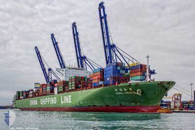
CSCL VENUS
Container Ship
Current Trip
| Time Travelled | 1 day |
|---|---|
| Remaining Time | --- |
| Distance Travelled | 351.19 nm |
| Remaining Distance | 5.64 nm |
| AVG Speed | 13.7 Knots |
| MAX Speed | 18.9 Knots |
| AVG Wind | 13.9 knots |
| MAX Wind | 20 knots |
| MIN Temp | 21.1°C / 69.98°F |
| MAX Temp | 31.5°C / 88.7°F |
| Draught | 11.7 m |
| Position Received | 1 m ago |
Current Position
| Longitude | 23.58132° |
|---|---|
| Latitude | 37.85628° |
| Status | Under way using engine |
| Speed | 0.6 Knots |
| Course | 288° |
| Area | Aegean Sea |
| Station | T-AIS |
| Position Received | 1 m ago |
Info
Information
The current position of CSCL VENUS is in Aegean Sea with coordinates 37.85628° / 23.58132° as reported on 2024-06-27 03:20 by AIS to our vessel tracker app. The vessel's current speed is 0.6 Knots and is heading at the port of PIRAEUS. The estimated time of arrival as calculated by vessel tracking app is 2024-06-27 03:00 LT
The vessel CSCL VENUS (IMO: 9467251, MMSI: 477266800) is a Container Ship that was built in 2011 ( 13 years old ). It's sailing under the flag of [HK] Hong Kong.
In this page you can find informations about the vessels current position, last detected port calls, and current voyage information. If the vessels is not in coverage by AIS you will find the latest position.
The current position of CSCL VENUS is detected by our AIS receivers and we are not responsible for the reliability of the data. The last position was recorded while the vessel was in Coverage by the Ais receivers of our vessel tracking app.
The current draught of CSCL VENUS as reported by AIS is 11.7 meters
Weather
| Temperature | 24.9°C / 76.82°F |
|---|---|
| Wind Speed | 7 knots |
| Direction | 348° NNW |
| Pressure | 1010.9 hPa |
| Humidity | 66.9 % |
| Cloud Coverage | --- |
Featured Company
Last Port Calls
| Port | Arrival | Departure | Time In Port |
|---|---|---|---|
| 2024-06-24 14:14 | 2024-06-26 02:30 | 1 d | |
| 2024-06-23 07:17 | 2024-06-24 08:56 | 1 d | |
| 2024-06-18 22:57 | 2024-06-21 04:39 | 2 d | |
| 2024-06-14 01:40 | 2024-06-15 07:14 | 1 d | |
| 2024-05-13 10:58 | 2024-05-14 15:54 | 1 d | |
| 2024-05-07 23:40 | 2024-05-08 08:47 | 9 h | |
| 2024-05-07 00:28 | 2024-05-07 15:12 | 14 h | |
| 2024-05-01 05:13 | 2024-05-01 20:25 | 15 h | |
| 2024-04-29 00:24 | 2024-04-29 13:44 | 13 h | |
| 2024-04-24 08:24 | 2024-04-24 20:32 | 12 h |
Last Trips
| Origin | Departure | Destination | Arrival | Distance | |
|---|---|---|---|---|---|
| 2024-06-24 11:56 | 2024-06-24 17:14 | 59.15 nm | |||
| 2024-06-21 07:39 | 2024-06-23 10:17 | 433.14 nm | |||
| 2024-06-15 09:14 | 2024-06-19 01:57 | 1266.61 nm | |||
| 2024-05-14 23:54 | 2024-06-14 03:40 | 11232.72 nm | |||
| 2024-05-08 16:47 | 2024-05-13 18:58 | 1473.75 nm | |||
| 2024-05-07 23:12 | 2024-05-08 07:40 | 95.11 nm | |||
| 2024-05-02 04:25 | 2024-05-07 08:28 | 1091.75 nm | |||
| 2024-04-29 21:44 | 2024-05-01 13:13 | 480.63 nm | |||
| 2024-04-25 04:32 | 2024-04-29 08:24 | 549.97 nm | |||
| 2024-04-21 23:56 | 2024-04-24 16:24 | 782.92 nm |
Events
| Time | Event | Details | Position / Dest | Info |
|---|---|---|---|---|
| 2024-06-27 03:09 | ETA Changed | 2024/06/27 03:00 2025/01/01 03:00 |
37.85795 / 23.58281
GRPIR
|
Speed: 0.8 kn Course: 298° |
| 2024-06-27 03:03 | ETA Changed | 2025/01/01 03:00 2024/06/27 03:00 |
37.85807 / 23.58645
GRPIR
|
Speed: 5 kn Course: 280.3° |
| 2024-06-26 12:14 | Change Sea Area | Greek part of the Aegean Sea Turkish part of the Aegean Sea |
39.91507 / 25.81840
Aegean Sea
GRPIR
|
Speed: 14.4 kn Course: 231.7° |
| 2024-06-26 11:52 | Status Changed | Under way using engine Default |
39.96846 / 25.90903
GRPIR
|
Speed: 15.1 kn Course: 231° |
| 2024-06-26 11:14 | Status Changed | Default Under way using engine |
40.01976 / 26.10436
GRPIR
|
Speed: 14.8 kn Course: 261.1° |
| 2024-06-26 11:09 | Change Sea Area | Turkish part of the Aegean Sea Turkish part of the Sea of Marmara |
40.02222 / 26.12693
Aegean Sea
GRPIR
|
Speed: 14.8 kn Course: 261.1° |
| 2024-06-26 11:09 | Status Changed | Under way using engine Default |
40.02222 / 26.12693
GRPIR
|
Speed: 14.3 kn Course: 258° |
| 2024-06-26 10:55 | Status Changed | Default Under way using engine |
40.03403 / 26.19522
GRPIR
|
Speed: 16.7 kn Course: 247.1° |
| 2024-06-26 09:39 | Destination Changed | GRPIR GELIBOLU P/S |
40.24348 / 26.48388
GRPIR
|
Speed: 15 kn Course: 232.9° |
| 2024-06-26 09:39 | ETA Changed | 2024/06/27 03:00 2024/06/26 08:45 |
40.24348 / 26.48388
GRPIR
|
Speed: 15 kn Course: 232.9° |