
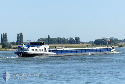
DAMIATE
Other Type
Current Trip
| Trip Time | 6 days |
|---|---|
| Trip Distance | 326.98 nm |
| AVG Speed | 6.6 Knots |
| MAX Speed | 9.7 Knots |
| Draught | 1.1 m |
| AVG Wind | 7.1 knots |
| MAX Wind | 9.9 knots |
| MIN Temp | 10.8°C / 51.44°F |
| MAX Temp | 30.5°C / 86.9°F |
| Position Received | 1 h, 9 m ago |
Current Position
| Longitude | 11.49753° |
|---|---|
| Latitude | 52.25193° |
| Status | Moored |
| Speed | 0.1 Knots |
| Course | 300° |
| Area | North Sea |
| Station | T-AIS |
| Position Received | 1 h, 9 m ago |
Info
Information
The current position of DAMIATE is in North Sea with coordinates 52.25193° / 11.49753° as reported on 2024-06-27 09:46 by AIS to our vessel tracker app. The vessel's current speed is 0.1 Knots and is currently inside the port of VAHLDORF.
The vessel DAMIATE (MMSI: 244700319) is a Other Type It's sailing under the flag of [NL] Netherlands.
In this page you can find informations about the vessels current position, last detected port calls, and current voyage information. If the vessels is not in coverage by AIS you will find the latest position.
The current position of DAMIATE is detected by our AIS receivers and we are not responsible for the reliability of the data. The last position was recorded while the vessel was in Coverage by the Ais receivers of our vessel tracking app.
The current draught of DAMIATE as reported by AIS is 1.1 meters
Weather
| Temperature | 27.4°C / 81.32°F |
|---|---|
| Wind Speed | 7 knots |
| Direction | 124° SE |
| Pressure | 1007.9 hPa |
| Humidity | 57.5 % |
| Cloud Coverage | 51 % |
Featured Company
Last Port Calls
| Port | Arrival | Departure | Time In Port |
|---|---|---|---|
| 2024-06-26 14:57 | |||
| 2024-06-19 20:07 | 2024-06-20 03:01 | 6 h | |
| 2024-06-19 17:35 | 2024-06-19 18:49 | 1 h | |
| 2024-06-19 12:35 | 2024-06-19 15:50 | 3 h | |
| 2024-06-18 20:30 | |||
| 2024-06-11 17:35 | 2024-06-12 02:39 | 9 h | |
| 2024-06-11 13:41 | 2024-06-11 13:56 | 15 m | |
| 2024-06-10 21:54 | 2024-06-11 07:14 | 9 h | |
| 2024-06-08 13:28 | 2024-06-08 13:43 | 14 m | |
| 2024-06-08 10:31 | 2024-06-08 11:59 | 1 h |
Last Trips
| Origin | Departure | Destination | Arrival | Distance | |
|---|---|---|---|---|---|
| 2024-06-20 05:01 | 2024-06-26 16:57 | 326.98 nm | |||
| 2024-06-19 20:49 | 2024-06-19 22:07 | 10.67 nm | |||
| 2024-06-19 17:50 | 2024-06-19 19:35 | 9.35 nm | |||
| 2024-06-18 22:30 | 2024-06-19 14:35 | 23.68 nm | |||
| 2024-06-11 15:56 | 2024-06-11 19:35 | 21.11 nm | |||
| 2024-06-11 09:14 | 2024-06-11 15:41 | 42.79 nm | |||
| 2024-06-08 15:43 | 2024-06-10 23:54 | 245.59 nm | |||
| 2024-06-08 13:59 | 2024-06-08 15:28 | 5.02 nm | |||
| 2024-06-08 12:16 | 2024-06-08 12:31 | 0.83 nm | |||
| 2024-06-07 15:56 | 2024-06-08 11:23 | 9.84 nm |
Events
| Time | Event | Details | Position / Dest | Info |
|---|---|---|---|---|
| 2024-06-27 09:46 | OUT of Coverage |
52.25193 / 11.49753
North Sea
[DE] VAHLDORF
|
Speed: 0.1 kn Course: 300° |
|
| 2024-06-27 05:08 | Destination Changed | NAAR HUIS AKEN |
52.25182 / 11.49791
[DE] VAHLDORF
|
Speed: Course: 293° |
| 2024-06-26 15:08 | Status Changed | Moored Under way using engine |
52.25193 / 11.49717
[DE] VAHLDORF
|
Speed: 0.1 kn Course: 305° |
| 2024-06-26 14:57 | STOP Moving |
52.25205 / 11.49727
[DE] VAHLDORF
|
Speed: 0.2 kn Course: 303° |
|
| 2024-06-26 14:57 | PORT ARRIVAL |
|
52.25206 / 11.49727
[DE] VAHLDORF
|
Speed: 1.9 kn Course: 311° |
| 2024-06-26 14:37 | IN Coverage |
52.25828 / 11.47969
North Sea
|
Speed: 4.6 kn Course: 118° |
|
| 2024-06-25 13:27 | OUT of Coverage |
52.40705 / 9.74182
North Sea
|
Speed: 6 kn Course: 115.3° |
|
| 2024-06-25 13:12 | IN Coverage |
52.41895 / 9.70716
North Sea
|
Speed: 5.7 kn Course: 119.9° |
|
| 2024-06-25 11:36 | OUT of Coverage |
52.40184 / 9.46940
North Sea
|
Speed: 5.8 kn Course: 68.9° |
|
| 2024-06-25 10:49 | IN Coverage |
52.38932 / 9.35221
North Sea
|
Speed: 5.4 kn Course: 85.9° |