
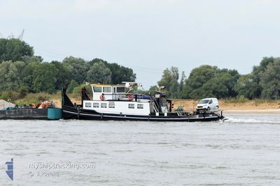
DANIQUE F
Cargo
Current Trip
STEIN
| Time Travelled | 5 days |
|---|---|
| Remaining Time | --- |
| Distance Travelled | 79.79 nm |
| Remaining Distance | --- |
| AVG Speed | 4.6 Knots |
| MAX Speed | 10.5 Knots |
| AVG Wind | 5.3 knots |
| MAX Wind | 14 knots |
| MIN Temp | 6.1°C / 42.98°F |
| MAX Temp | 18.7°C / 65.66°F |
| Draught | 3.4 m |
| Position Received | 1 d ago |
Current Position
| Longitude | 5.68970° |
|---|---|
| Latitude | 50.78757° |
| Status | Under way using engine |
| Speed | 7.6 Knots |
| Course | 191.7° |
| Area | North Sea |
| Station | T-AIS |
| Position Received | 1 d ago |
Info
Information
The current position of DANIQUE F is in North Sea with coordinates 50.78757° / 5.68970° as reported on 2024-05-27 16:16 by AIS to our vessel tracker app. The vessel's current speed is 7.6 Knots
The vessel DANIQUE F (MMSI: 205228790) is a Cargo It's sailing under the flag of [BE] Belgium.
In this page you can find informations about the vessels current position, last detected port calls, and current voyage information. If the vessels is not in coverage by AIS you will find the latest position.
The current position of DANIQUE F is detected by our AIS receivers and we are not responsible for the reliability of the data. The last position was recorded while the vessel was in Coverage by the Ais receivers of our vessel tracking app.
The current draught of DANIQUE F as reported by AIS is 3.4 meters
Weather
| Temperature | 12.9°C / 55.22°F |
|---|---|
| Wind Speed | 13 knots |
| Direction | 196° SSW |
| Pressure | 1013.8 hPa |
| Humidity | 96.6 % |
| Cloud Coverage | 100 % |
Featured Company
Last Port Calls
| Port | Arrival | Departure | Time In Port |
|---|---|---|---|
| 2024-05-23 16:17 | 2024-05-23 16:48 | 31 m | |
| 2024-05-17 07:51 | 2024-05-17 08:24 | 33 m | |
| 2024-05-15 23:04 | 2024-05-16 12:29 | 13 h | |
| 2024-05-15 18:51 | 2024-05-15 18:53 | 1 m | |
| 2024-05-10 17:18 | 2024-05-11 05:41 | 12 h | |
| 2024-05-08 17:46 | 2024-05-09 14:06 | 20 h | |
| 2024-05-07 14:01 | 2024-05-08 14:19 | 1 d | |
| 2024-05-07 07:49 | 2024-05-07 08:23 | 34 m | |
| 2024-05-07 07:28 | 2024-05-07 07:30 | 2 m | |
| 2024-05-03 15:53 | 2024-05-03 16:25 | 32 m |
Last Trips
| Origin | Departure | Destination | Arrival | Distance | |
|---|---|---|---|---|---|
| 2024-05-17 10:24 | 2024-05-23 18:17 | 157.50 nm | |||
| 2024-05-16 14:29 | 2024-05-17 09:51 | 45.99 nm | |||
| 2024-05-15 20:53 | 2024-05-16 01:04 | 21.89 nm | |||
| 2024-05-11 07:41 | 2024-05-15 20:51 | 104.04 nm | |||
| 2024-05-09 16:06 | 2024-05-10 19:18 | 23.59 nm | |||
| 2024-05-08 16:19 | 2024-05-08 19:46 | 15.97 nm | |||
| 2024-05-07 10:23 | 2024-05-07 16:01 | 16.14 nm | |||
| 2024-05-07 09:30 | 2024-05-07 09:49 | 2.12 nm | |||
| 2024-05-03 18:25 | 2024-05-07 09:28 | 30.01 nm | |||
| 2024-05-03 14:20 | 2024-05-03 17:53 | 16.41 nm |
Events
| Time | Event | Details | Position / Dest | Info |
|---|---|---|---|---|
| 2024-05-28 19:19 | STOP Moving | 4.71 nm, South West of ENGIS |
50.53333 / 5.28833
STEIN
|
Speed: Course: -1° |
| 2024-05-28 17:34 | START Moving | 13.17 nm, West of ENGIS |
50.49333 / 5.07333
STEIN
|
Speed: 5 kn Course: 102° |
| 2024-05-28 17:19 | STOP Moving | 13.31 nm, West of ENGIS |
50.49500 / 5.06833
STEIN
|
Speed: Course: -1° |
| 2024-05-28 05:55 | STOP Moving | 18.67 nm, East of CHARLEROI |
50.46500 / 4.91667
STEIN
|
Speed: Course: -1° |
| 2024-05-28 04:45 | START Moving | 15.12 nm, West of ENGIS |
50.48833 / 5.02167
STEIN
|
Speed: 6 kn Course: 222° |
| 2024-05-27 22:51 | STOP Moving | 13.11 nm, West of ENGIS |
50.49333 / 5.07500
STEIN
|
Speed: Course: -1° |
| 2024-05-27 21:57 | START Moving | 8.01 nm, West of ENGIS |
50.52500 / 5.19833
STEIN
|
Speed: 6 kn Course: 231° |
| 2024-05-27 20:39 | STOP Moving | 4.35 nm, South West of ENGIS |
50.53167 / 5.30167
STEIN
|
Speed: Course: -1° |
| 2024-05-27 16:30 | Status Changed | Default Under way using engine |
50.75834 / 5.67667
STEIN
|
Speed: 7.6 kn Course: 191.7° |
| 2024-05-27 16:16 | OUT of Coverage |
50.78757 / 5.68970
North Sea
|
Speed: 7.6 kn Course: 191.7° |