
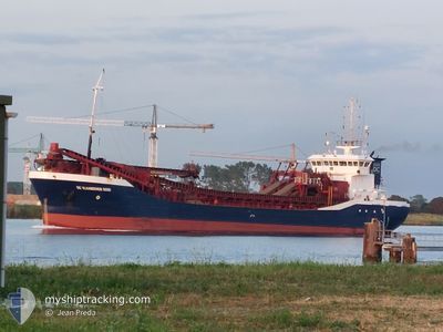
DC VLAANDEREN 3000
Trailing Suction Hopper Dredger
Current Trip
NORTHFLEET
| Time Travelled | 7 h, 31 mins |
|---|---|
| Remaining Time | --- |
| Distance Travelled | 69.49 nm |
| Remaining Distance | --- |
| AVG Speed | 11.8 Knots |
| MAX Speed | 14 Knots |
| AVG Wind | 16.1 knots |
| MAX Wind | 19.9 knots |
| MIN Temp | 12.9°C / 55.22°F |
| MAX Temp | 14.4°C / 57.92°F |
| Draught | 6.5 m |
| Position Received | Now |
Current Position
| Longitude | 1.73419° |
|---|---|
| Latitude | 52.01453° |
| Status | Under way using engine |
| Speed | 0.1 Knots |
| Course | 216° |
| Area | North Sea |
| Station | T-AIS |
| Position Received | Now |
Info
Information
The current position of DC VLAANDEREN 3000 is in North Sea with coordinates 52.01453° / 1.73419° as reported on 2024-05-29 05:23 by AIS to our vessel tracker app. The vessel's current speed is 0.1 Knots
The vessel DC VLAANDEREN 3000 (IMO: 9250373, MMSI: 245381000) is a Trailing Suction Hopper Dredger that was built in 2002 ( 22 years old ). It's sailing under the flag of [NL] Netherlands.
In this page you can find informations about the vessels current position, last detected port calls, and current voyage information. If the vessels is not in coverage by AIS you will find the latest position.
The current position of DC VLAANDEREN 3000 is detected by our AIS receivers and we are not responsible for the reliability of the data. The last position was recorded while the vessel was in Coverage by the Ais receivers of our vessel tracking app.
The current draught of DC VLAANDEREN 3000 as reported by AIS is 6.5 meters
Weather
| Temperature | 13°C / 55.4°F |
|---|---|
| Wind Speed | 20 knots |
| Direction | 264° W |
| Pressure | 1007.4 hPa |
| Humidity | 91.7 % |
| Cloud Coverage | 88 % |
Featured Company
Last Port Calls
| Port | Arrival | Departure | Time In Port |
|---|---|---|---|
| 2024-05-28 15:26 | 2024-05-28 21:53 | 6 h | |
| 2024-05-28 01:04 | 2024-05-28 03:24 | 2 h | |
| 2024-05-27 10:22 | 2024-05-27 13:04 | 2 h | |
| 2024-05-25 06:27 | 2024-05-27 00:32 | 1 d | |
| 2024-05-24 10:47 | 2024-05-24 22:50 | 12 h | |
| 2024-05-23 22:43 | 2024-05-24 01:58 | 3 h | |
| 2024-05-23 14:05 | 2024-05-23 15:25 | 1 h | |
| 2024-05-23 08:39 | 2024-05-23 12:53 | 4 h | |
| 2024-05-22 18:03 | 2024-05-22 20:26 | 2 h | |
| 2024-05-21 09:24 | 2024-05-21 13:32 | 4 h |
Most Visited Ports (Last year)
| Port | Arrivals | |
|---|---|---|
| 131 | ||
| 39 | ||
| 38 | ||
| 30 | ||
| 28 | ||
| 23 |
Last Trips
| Origin | Departure | Destination | Arrival | Distance | |
|---|---|---|---|---|---|
| 2024-05-28 04:24 | 2024-05-28 16:26 | 99.84 nm | |||
| 2024-05-27 14:04 | 2024-05-28 02:04 | 76.95 nm | |||
| 2024-05-27 02:32 | 2024-05-27 11:22 | 90.29 nm | |||
| 2024-05-25 00:50 | 2024-05-25 08:27 | 74.27 nm | |||
| 2024-05-24 03:58 | 2024-05-24 12:47 | 55.27 nm | |||
| 2024-05-23 17:25 | 2024-05-24 00:43 | 72.16 nm | |||
| 2024-05-23 14:53 | 2024-05-23 16:05 | 8.60 nm | |||
| 2024-05-22 22:26 | 2024-05-23 10:39 | 71.44 nm | |||
| 2024-05-21 15:32 | 2024-05-22 20:03 | 166.71 nm | |||
| 2024-05-21 02:00 | 2024-05-21 11:24 | 100.46 nm |
Events
| Time | Event | Details | Position / Dest | Info |
|---|---|---|---|---|
| 2024-05-29 04:44 | STOP Moving | 16.6 nm, East of FELIXSTOWE |
52.01704 / 1.73707
NORTHFLEET
|
Speed: 0.3 kn Course: 218° |
| 2024-05-29 04:40 | START Moving | 16.71 nm, East of FELIXSTOWE |
52.01824 / 1.73983
NORTHFLEET
|
Speed: 3.1 kn Course: 223° |
| 2024-05-29 03:44 | STOP Moving | 16.56 nm, East of FELIXSTOWE |
52.01657 / 1.73613
NORTHFLEET
|
Speed: 0.3 kn Course: 223° |
| 2024-05-28 21:53 | PORT DEPARTURE |
|
51.44772 / .35212
NORTHFLEET
|
Speed: 12.5 kn Course: 91° |
| 2024-05-28 21:48 | START Moving |
51.45164 / .33064
[GB] NORTHFLEET
|
Speed: 6.6 kn Course: 114° |
|
| 2024-05-28 15:29 | STOP Moving |
51.45256 / .32782
[GB] NORTHFLEET
|
Speed: 0.3 kn Course: 148° |
|
| 2024-05-28 15:26 | PORT ARRIVAL |
|
51.45365 / .32790
[GB] NORTHFLEET
|
Speed: 2.2 kn Course: 166° |
| 2024-05-28 11:23 | Destination Changed | NORTHFLEET DREDGING AREA |
51.41485 / 1.48768
NORTHFLEET
|
Speed: 9.2 kn Course: 325.4° |
| 2024-05-28 11:23 | ETA Changed | 2024/05/28 16:00 2024/05/28 07:00 |
51.41485 / 1.48768
NORTHFLEET
|
Speed: 9.2 kn Course: 325.4° |
| 2024-05-28 07:41 | START Moving | 14.04 nm, South East of F HALLS COMPANY BOAT |
51.71036 / 1.58421
DREDGING AREA
|
Speed: 3.2 kn Course: 107° |