
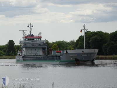
DOGGERSBANK
General Cargo
Current Trip
| Time Travelled | 1 day |
|---|---|
| Remaining Time | --- |
| Distance Travelled | 271.66 nm |
| Remaining Distance | --- |
| AVG Speed | 11.3 Knots |
| MAX Speed | 13.8 Knots |
| AVG Wind | 8.6 knots |
| MAX Wind | 12.8 knots |
| MIN Temp | 10.2°C / 50.36°F |
| MAX Temp | 13.2°C / 55.76°F |
| Draught | 3.9 m |
| Position Received | 5 m ago |
Current Position
| Longitude | 17.55758° |
|---|---|
| Latitude | 58.61121° |
| Status | At anchor |
| Speed | |
| Course | 98° |
| Area | Baltic Sea |
| Station | T-AIS |
| Position Received | 5 m ago |
Info
Information
The current position of DOGGERSBANK is in Baltic Sea with coordinates 58.61121° / 17.55758° as reported on 2024-06-02 10:04 by AIS to our vessel tracker app. The vessel's current speed is 0 Knots
The vessel DOGGERSBANK (IMO: 9341768, MMSI: 246555000) is a General Cargo that was built in 2006 ( 18 years old ). It's sailing under the flag of [NL] Netherlands.
In this page you can find informations about the vessels current position, last detected port calls, and current voyage information. If the vessels is not in coverage by AIS you will find the latest position.
The current position of DOGGERSBANK is detected by our AIS receivers and we are not responsible for the reliability of the data. The last position was recorded while the vessel was in Coverage by the Ais receivers of our vessel tracking app.
The current draught of DOGGERSBANK as reported by AIS is 3.9 meters
Weather
| Temperature | 13.2°C / 55.76°F |
|---|---|
| Wind Speed | 6 knots |
| Direction | 84° E |
| Pressure | 1011.9 hPa |
| Humidity | 84.6 % |
| Cloud Coverage | 95 % |
Featured Company
Last Port Calls
| Port | Arrival | Departure | Time In Port |
|---|---|---|---|
| 2024-05-29 03:42 | 2024-05-31 17:02 | 2 d | |
| 2024-05-25 00:52 | 2024-05-27 17:25 | 2 d | |
| 2024-05-23 16:04 | 2024-05-24 23:28 | 1 d | |
| 2024-05-19 06:15 | 2024-05-20 18:39 | 1 d | |
| 2024-05-08 11:01 | 2024-05-09 12:10 | 1 d | |
| 2024-05-02 03:51 | 2024-05-03 06:51 | 1 d | |
| 2024-04-27 01:27 | 2024-04-29 14:03 | 2 d | |
| 2024-04-26 06:59 | 2024-04-26 07:46 | 47 m |
Last Trips
| Origin | Departure | Destination | Arrival | Distance | |
|---|---|---|---|---|---|
| 2024-05-27 20:25 | 2024-05-29 06:42 | 290.29 nm | |||
| 2024-05-25 02:28 | 2024-05-25 03:52 | 15.97 nm | |||
| 2024-05-20 20:39 | 2024-05-23 19:04 | 747.21 nm | |||
| 2024-05-09 14:10 | 2024-05-19 08:15 | 542.75 nm | |||
| 2024-05-03 08:51 | 2024-05-08 13:01 | 460.26 nm | |||
| 2024-04-29 16:03 | 2024-05-02 05:51 | 147.05 nm | |||
| 2024-04-26 09:46 | 2024-04-27 03:27 | 147.75 nm | |||
| 2024-03-30 09:17 | 2024-04-26 08:59 | 1791.52 nm |
Events
| Time | Event | Details | Position / Dest | Info |
|---|---|---|---|---|
| 2024-06-02 05:58 | Status Changed | At anchor Default |
58.61005 / 17.55871
OXELOSUND
|
Speed: 0.1 kn Course: 18° |
| 2024-06-02 05:52 | Status Changed | Default At anchor |
58.60993 / 17.55905
OXELOSUND
|
Speed: 0.2 kn Course: 20° |
| 2024-06-01 19:40 | Status Changed | At anchor Default |
58.61156 / 17.55797
OXELOSUND
|
Speed: Course: 89° |
| 2024-06-01 19:34 | Status Changed | Default At anchor |
58.61149 / 17.55791
OXELOSUND
|
Speed: Course: 90° |
| 2024-06-01 16:09 | Status Changed | At anchor Under way using engine |
58.61005 / 17.55962
OXELOSUND
|
Speed: 0.7 kn Course: 8° |
| 2024-06-01 16:04 | STOP Moving | 10.32 nm, South East of STUDSVIK |
58.61046 / 17.56040
OXELOSUND
|
Speed: 0.3 kn Course: 355° |
| 2024-06-01 10:33 | Status Changed | Under way using engine Default |
58.99387 / 19.28789
OXELOSUND
|
Speed: 11.8 kn Course: 212° |
| 2024-06-01 10:14 | IN Coverage |
58.99387 / 19.28789
Baltic Sea
OXELOSUND
|
Speed: 11.8 kn Course: 210.9° |
|
| 2024-06-01 08:50 | Status Changed | Default Under way using engine |
59.28285 / 19.65216
OXELOSUND
|
Speed: 13.9 kn Course: 212.7° |
| 2024-06-01 08:44 | OUT of Coverage |
59.30326 / 19.67793
Baltic Sea
OXELOSUND
|
Speed: 13.9 kn Course: 212.7° |