
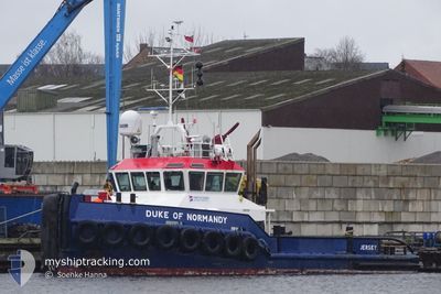
DUKE OF NORMANDY
Tug
Current Trip
GBTIL
| Time Travelled | 4 days |
|---|---|
| Remaining Time | --- |
| Distance Travelled | 22.37 nm |
| Remaining Distance | --- |
| AVG Speed | 4.5 Knots |
| MAX Speed | 5.9 Knots |
| AVG Wind | 15 knots |
| MAX Wind | 20.2 knots |
| MIN Temp | 5.3°C / 41.54°F |
| MAX Temp | 12.9°C / 55.22°F |
| Draught | 2.5 m |
| Position Received | Now |
Current Position
| Longitude | 0.73800° |
|---|---|
| Latitude | 51.47891° |
| Status | Restricted manoeuverability |
| Speed | |
| Course | --- |
| Area | North Sea |
| Station | T-AIS |
| Position Received | Now |
Info
Information
The current position of DUKE OF NORMANDY is in North Sea with coordinates 51.47891° / 0.73800° as reported on 2024-05-02 22:46 by AIS to our vessel tracker app. The vessel's current speed is 0 Knots
The vessel DUKE OF NORMANDY (IMO: 9348429, MMSI: 235026811) is a Tug that was built in 2005 ( 19 years old ). It's sailing under the flag of [GB] United Kingdom.
In this page you can find informations about the vessels current position, last detected port calls, and current voyage information. If the vessels is not in coverage by AIS you will find the latest position.
The current position of DUKE OF NORMANDY is detected by our AIS receivers and we are not responsible for the reliability of the data. The last position was recorded while the vessel was in Coverage by the Ais receivers of our vessel tracking app.
The current draught of DUKE OF NORMANDY as reported by AIS is 2.5 meters
Weather
| Temperature | 11.4°C / 52.52°F |
|---|---|
| Wind Speed | 15 knots |
| Direction | 257° WSW |
| Pressure | 1004.2 hPa |
| Humidity | 90.2 % |
| Cloud Coverage | 100 % |
Featured Company
Last Port Calls
| Port | Arrival | Departure | Time In Port |
|---|---|---|---|
| 2024-04-28 05:50 | 2024-04-28 09:35 | 3 h | |
| 2024-04-28 05:32 | 2024-04-28 05:40 | 7 m | |
| 2024-04-27 17:51 | 2024-04-28 05:17 | 11 h | |
| 2024-04-27 17:35 | 2024-04-27 17:42 | 6 m | |
| 2024-04-27 06:43 | 2024-04-27 17:19 | 10 h | |
| 2024-04-27 06:27 | 2024-04-27 06:32 | 5 m | |
| 2024-04-27 05:54 | 2024-04-27 06:12 | 18 m | |
| 2024-04-27 05:38 | 2024-04-27 05:44 | 6 m | |
| 2024-04-26 23:55 | 2024-04-27 05:24 | 5 h | |
| 2024-04-24 18:44 | 2024-04-24 20:00 | 1 h |
Last Trips
| Origin | Departure | Destination | Arrival | Distance | |
|---|---|---|---|---|---|
| 2024-04-28 06:40 | 2024-04-28 06:50 | 0.83 nm | |||
| 2024-04-28 06:17 | 2024-04-28 06:32 | 1.35 nm | |||
| 2024-04-27 18:42 | 2024-04-27 18:51 | 1.31 nm | |||
| 2024-04-27 18:19 | 2024-04-27 18:35 | 1.41 nm | |||
| 2024-04-27 07:32 | 2024-04-27 07:43 | 0.75 nm | |||
| 2024-04-27 07:12 | 2024-04-27 07:27 | 1.26 nm | |||
| 2024-04-27 06:44 | 2024-04-27 06:54 | 1.33 nm | |||
| 2024-04-27 06:24 | 2024-04-27 06:38 | 1.37 nm | |||
| 2024-04-24 21:00 | 2024-04-27 00:55 | 33.33 nm | |||
| 2024-04-15 19:30 | 2024-04-24 19:44 | 55.96 nm |
Events
| Time | Event | Details | Position / Dest | Info |
|---|---|---|---|---|
| 2024-05-01 00:04 | ETA Changed | 2025/04/14 23:15 2024/04/14 23:15 |
51.47890 / .73800
GBTIL
|
Speed: Course: 511° |
| 2024-04-30 20:25 | STOP Moving | 2.3 nm, North of SHEERNESS |
51.47895 / .73803
GBTIL
|
Speed: 0.3 kn Course: 511° |
| 2024-04-30 19:46 | START Moving | 3.67 nm, North East of SHEERNESS |
51.48334 / .81025
GBTIL
|
Speed: 4 kn Course: 274.2° |
| 2024-04-30 00:19 | STOP Moving | 3.74 nm, North East of SHEERNESS |
51.48320 / .81325
GBTIL
|
Speed: 0.3 kn Course: 511° |
| 2024-04-29 23:48 | START Moving | 2.55 nm, North of SHEERNESS |
51.48082 / .76222
GBTIL
|
Speed: 4.7 kn Course: 86.1° |
| 2024-04-29 23:17 | STOP Moving | 2.49 nm, North of SHEERNESS |
51.48045 / .75932
GBTIL
|
Speed: 0.2 kn Course: 511° |
| 2024-04-29 22:49 | START Moving | 3.68 nm, North East of SHEERNESS |
51.48355 / .81066
GBTIL
|
Speed: 3.1 kn Course: 269.6° |
| 2024-04-29 17:27 | STOP Moving | 3.76 nm, North East of SHEERNESS |
51.48308 / .81404
GBTIL
|
Speed: 0.3 kn Course: 511° |
| 2024-04-29 16:58 | START Moving | 2.52 nm, North of SHEERNESS |
51.48073 / .76063
GBTIL
|
Speed: 3.9 kn Course: 74.4° |
| 2024-04-29 07:22 | Status Changed | Restricted manoeuverability Default |
51.48045 / .75741
GBTIL
|
Speed: Course: -1° |