
EAGLE BARENTS
Tanker
Current Trip
| Time Travelled | 29 days |
|---|---|
| Remaining Time | --- |
| Distance Travelled | 999.13 nm |
| Remaining Distance | 1.94 nm |
| AVG Speed | 8.7 Knots |
| MAX Speed | 11.6 Knots |
| AVG Wind | 13.4 knots |
| MAX Wind | 29 knots |
| MIN Temp | 9.4°C / 48.92°F |
| MAX Temp | 18.5°C / 65.3°F |
| Draught | 9.8 m |
| Position Received | 1 m ago |
Current Position
| Longitude | 5.70206° |
|---|---|
| Latitude | 59.02293° |
| Status | At anchor |
| Speed | 0.1 Knots |
| Course | 304° |
| Area | North Sea |
| Station | T-AIS |
| Position Received | 1 m ago |
Info
Information
The current position of EAGLE BARENTS is in North Sea with coordinates 59.02293° / 5.70206° as reported on 2024-06-09 16:26 by AIS to our vessel tracker app. The vessel's current speed is 0.1 Knots and is heading at the port of STAVANGER. The estimated time of arrival as calculated by vessel tracking app is 2024-06-07 11:00 LT
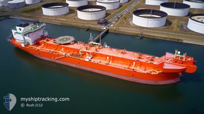
The vessel EAGLE BARENTS (IMO: 9676125, MMSI: 257980000) is a Tanker It's sailing under the flag of [NO] Norway.
In this page you can find informations about the vessels current position, last detected port calls, and current voyage information. If the vessels is not in coverage by AIS you will find the latest position.
The current position of EAGLE BARENTS is detected by our AIS receivers and we are not responsible for the reliability of the data. The last position was recorded while the vessel was in Coverage by the Ais receivers of our vessel tracking app.
The current draught of EAGLE BARENTS as reported by AIS is 9.8 meters
Weather
| Temperature | 11.3°C / 52.34°F |
|---|---|
| Wind Speed | 18 knots |
| Direction | 288° WNW |
| Pressure | 993.4 hPa |
| Humidity | 81.3 % |
| Cloud Coverage | 68 % |
Featured Company
Events
| Time | Event | Details | Position / Dest | Info |
|---|---|---|---|---|
| 2024-06-08 23:47 | Status Changed | At anchor Default |
59.02335 / 5.69444
NOSVG
|
Speed: 0.1 kn Course: 40° |
| 2024-06-08 23:41 | Status Changed | Default At anchor |
59.02322 / 5.69461
NOSVG
|
Speed: 0.1 kn Course: 40° |
| 2024-06-07 13:13 | Status Changed | At anchor Under way using engine |
59.02436 / 5.70218
NOSVG
|
Speed: 0.2 kn Course: 271° |
| 2024-06-07 12:44 | STOP Moving | 1.3 nm, South East of BRU |
59.02361 / 5.69779
NOSVG
|
Speed: 0.3 kn Course: 286° |
| 2024-06-06 21:07 | Detected in Sea | Norwegian part of the North Sea |
57.79284 / 7.36162
North Sea
NOSVG
|
Speed: 8.9 kn Course: 275.1° |
| 2024-06-06 15:14 | Detected in Sea | Norwegian part of the Skaggerak |
57.81837 / 9.08434
Skaggerak
NOSVG
|
Speed: 9.8 kn Course: 266.4° |
| 2024-06-06 08:47 | Change Sea Area | Danish part of the Skaggerak Danish part of the Kattegat |
57.77785 / 10.81057
Skaggerak
NOSVG
|
Speed: 9.2 kn Course: 4.7° |
| 2024-06-06 07:51 | START Moving | 2.75 nm, East of SKAGEN |
57.69926 / 10.67735
NOSVG
|
Speed: 3.1 kn Course: 152° |
| 2024-06-06 07:33 | Status Changed | Under way using engine At anchor |
57.70138 / 10.67419
NOSVG
|
Speed: 0.1 kn Course: 225° |
| 2024-06-06 05:53 | ETA Changed | 2024/06/07 11:00 2024/06/07 13:30 |
57.70275 / 10.67578
NOSVG
|
Speed: Course: 231° |