
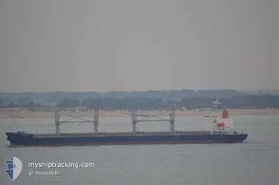
EASTGATE
General Cargo
Current Trip
VNPHU
| Time Travelled | 4 days |
|---|---|
| Remaining Time | --- |
| Distance Travelled | 1132.13 nm |
| Remaining Distance | --- |
| AVG Speed | 11.3 Knots |
| MAX Speed | 12.9 Knots |
| AVG Wind | 8.6 knots |
| MAX Wind | 16 knots |
| MIN Temp | 26.4°C / 79.52°F |
| MAX Temp | 30.2°C / 86.36°F |
| Draught | 11 m |
| Position Received | 4 d ago |
Current Position
| Longitude | 106.99634° |
|---|---|
| Latitude | 10.46570° |
| Status | Under way using engine |
| Speed | 10.9 Knots |
| Course | 182.2° |
| Area | South China Sea |
| Station | T-AIS |
| Position Received | 4 d ago |
Info
Information
The current position of EASTGATE is in South China Sea with coordinates 10.46570° / 106.99634° as reported on 2024-06-23 07:38 by AIS to our vessel tracker app. The vessel's current speed is 10.9 Knots
The vessel EASTGATE (IMO: 9478468, MMSI: 636017271) is a General Cargo that was built in 2010 ( 14 years old ). It's sailing under the flag of [LR] Liberia.
In this page you can find informations about the vessels current position, last detected port calls, and current voyage information. If the vessels is not in coverage by AIS you will find the latest position.
The current position of EASTGATE is detected by our AIS receivers and we are not responsible for the reliability of the data. The last position was recorded while the vessel was in Coverage by the Ais receivers of our vessel tracking app.
The current draught of EASTGATE as reported by AIS is 11 meters
Weather
| Temperature | 28.7°C / 83.66°F |
|---|---|
| Wind Speed | 9 knots |
| Direction | 99° E |
| Pressure | 1007.8 hPa |
| Humidity | 76.4 % |
| Cloud Coverage | 15 % |
Featured Company
Last Port Calls
| Port | Arrival | Departure | Time In Port |
|---|---|---|---|
| 2024-06-19 05:13 | 2024-06-23 06:57 | 4 d | |
| 2024-05-28 23:06 | 2024-05-30 08:43 | 1 d | |
| 2024-05-24 17:55 | 2024-05-26 18:08 | 2 d | |
| 2024-05-19 16:59 | 2024-05-23 06:47 | 3 d | |
| 2024-05-12 20:45 | 2024-05-15 15:19 | 2 d | |
| 2024-05-06 18:19 | 2024-05-09 03:56 | 2 d | |
| 2024-04-30 02:11 | 2024-05-03 03:20 | 3 d | |
| 2024-04-02 23:40 | 2024-04-06 22:56 | 3 d |
Last Trips
| Origin | Departure | Destination | Arrival | Distance | |
|---|---|---|---|---|---|
| 2024-05-30 18:43 | 2024-06-19 12:13 | 4855.90 nm | |||
| 2024-05-27 04:08 | 2024-05-29 09:06 | 254.87 nm | |||
| 2024-05-23 16:47 | 2024-05-25 03:55 | 137.11 nm | |||
| 2024-05-16 01:19 | 2024-05-20 02:59 | 790.67 nm | |||
| 2024-05-09 13:56 | 2024-05-13 06:45 | 700.54 nm | |||
| 2024-05-03 13:20 | 2024-05-07 04:19 | 766.56 nm | |||
| 2024-04-07 05:56 | 2024-04-30 12:11 | 3154.31 nm | |||
| 2024-02-22 22:04 | 2024-04-03 06:40 | 8606.43 nm |
Events
| Time | Event | Details | Position / Dest | Info |
|---|---|---|---|---|
| 2024-06-23 07:46 | Status Changed | Default Under way using engine |
10.44492 / 107.00379
VNPHU
|
Speed: 10.9 kn Course: 182.2° |
| 2024-06-23 07:38 | OUT of Coverage |
10.46570 / 106.99634
South China Sea
|
Speed: 10.9 kn Course: 182.2° |
|
| 2024-06-23 07:35 | Status Changed | Under way using engine Default |
10.47428 / 106.99670
VNPHU
|
Speed: 10.9 kn Course: 182° |
| 2024-06-23 06:57 | PORT DEPARTURE |
|
10.56313 / 107.01204
VNPHU
|
Speed: 8.9 kn Course: 215° |
| 2024-06-23 06:50 | START Moving |
10.57826 / 107.02379
[VN] PHU MY
|
Speed: 6.1 kn Course: 220° |
|
| 2024-06-23 06:50 | Status Changed | Default Under way using engine |
10.57826 / 107.02379
[VN] PHU MY
|
Speed: 1.5 kn Course: 186° |
| 2024-06-23 06:41 | Status Changed | Under way using engine Default |
10.58828 / 107.02685
[VN] PHU MY
|
Speed: 0.3 kn Course: 356° |
| 2024-06-23 06:09 | Status Changed | Default Moored |
10.58779 / 107.02822
[VN] PHU MY
|
Speed: Course: 0° |
| 2024-06-23 06:03 | Status Changed | Moored Default |
10.58779 / 107.02825
[VN] PHU MY
|
Speed: Course: 92° |
| 2024-06-23 05:46 | IN Coverage |
10.58779 / 107.02825
South China Sea
[VN] PHU MY
|
Speed: Course: 92.3° |