
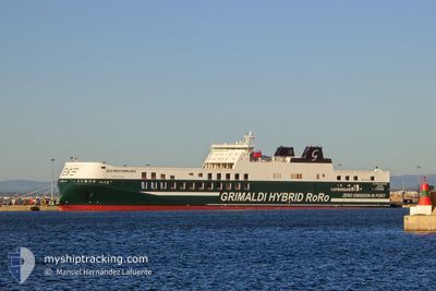
ECO MEDITERRANEA
Cargo
Current Trip
| Time Travelled | 15 h, 57 mins |
|---|---|
| Remaining Time | 4 h, 55 mins |
| Distance Travelled | 244.74 nm |
| Remaining Distance | 100.33 nm |
| AVG Speed | 16.4 Knots |
| MAX Speed | 17.2 Knots |
| AVG Wind | 6.9 knots |
| MAX Wind | 12.8 knots |
| MIN Temp | 18.6°C / 65.48°F |
| MAX Temp | 21.6°C / 70.88°F |
| Draught | 7.1 m |
| Position Received | 1 h, 2 m ago |
Current Position
| Longitude | 16.48911° |
|---|---|
| Latitude | 41.84115° |
| Status | Under way using engine |
| Speed | 16.7 Knots |
| Course | 131° |
| Area | Adriatic Sea |
| Station | T-AIS |
| Position Received | 1 h, 2 m ago |
Info
Information
The current position of ECO MEDITERRANEA is in Adriatic Sea with coordinates 41.84115° / 16.48911° as reported on 2024-06-03 00:38 by AIS to our vessel tracker app. The vessel's current speed is 16.7 Knots and is heading at the port of BRINDISI. The estimated time of arrival as calculated by vessel tracking app is 2024-06-03 06:36 LT
The vessel ECO MEDITERRANEA (IMO: 9859595, MMSI: 247383900) is a Cargo It's sailing under the flag of [IT] Italy.
In this page you can find informations about the vessels current position, last detected port calls, and current voyage information. If the vessels is not in coverage by AIS you will find the latest position.
The current position of ECO MEDITERRANEA is detected by our AIS receivers and we are not responsible for the reliability of the data. The last position was recorded while the vessel was in Coverage by the Ais receivers of our vessel tracking app.
The current draught of ECO MEDITERRANEA as reported by AIS is 7.1 meters
Weather
| Temperature | 19.5°C / 67.1°F |
|---|---|
| Wind Speed | 10 knots |
| Direction | 283° WNW |
| Pressure | 1013.4 hPa |
| Humidity | 86.9 % |
| Cloud Coverage | 100 % |
Featured Company
Last Port Calls
| Port | Arrival | Departure | Time In Port |
|---|---|---|---|
| 2024-06-01 12:42 | 2024-06-02 09:44 | 21 h | |
| 2024-05-31 12:34 | 2024-05-31 16:08 | 3 h | |
| 2024-05-30 11:15 | 2024-05-30 20:26 | 9 h | |
| 2024-05-29 14:58 | 2024-05-29 18:22 | 3 h | |
| 2024-05-28 05:55 | 2024-05-28 19:06 | 13 h | |
| 2024-05-26 14:44 | 2024-05-27 07:33 | 16 h | |
| 2024-05-25 13:39 | 2024-05-25 22:35 | 8 h | |
| 2024-05-24 17:02 | 2024-05-24 21:02 | 4 h | |
| 2024-05-23 09:11 | 2024-05-23 21:14 | 12 h | |
| 2024-05-22 09:53 | 2024-05-22 13:11 | 3 h |
Last Trips
| Origin | Departure | Destination | Arrival | Distance | |
|---|---|---|---|---|---|
| 2024-05-31 18:08 | 2024-06-01 14:42 | 348.01 nm | |||
| 2024-05-30 22:26 | 2024-05-31 14:34 | 283.10 nm | |||
| 2024-05-29 20:22 | 2024-05-30 13:15 | 277.55 nm | |||
| 2024-05-28 21:06 | 2024-05-29 16:58 | 352.31 nm | |||
| 2024-05-27 09:33 | 2024-05-28 07:55 | 347.24 nm | |||
| 2024-05-26 00:35 | 2024-05-26 16:44 | 285.23 nm | |||
| 2024-05-24 23:02 | 2024-05-25 15:39 | 282.21 nm | |||
| 2024-05-23 23:14 | 2024-05-24 19:02 | 351.98 nm | |||
| 2024-05-22 15:11 | 2024-05-23 11:11 | 348.63 nm | |||
| 2024-05-21 20:12 | 2024-05-22 11:53 | 286.19 nm |
Events
| Time | Event | Details | Position / Dest | Info |
|---|---|---|---|---|
| 2024-06-03 00:50 | Status Changed | Default Under way using engine |
41.84419 / 16.48441
ITRAN>ITBDS
|
Speed: 16.7 kn Course: 131° |
| 2024-06-03 00:38 | OUT of Coverage |
41.84115 / 16.48911
Adriatic Sea
ITRAN>ITBDS
|
Speed: 16.7 kn Course: 131° |
|
| 2024-06-03 00:12 | Status Changed | Under way using engine Default |
41.92311 / 16.36850
ITRAN>ITBDS
|
Speed: 16.9 kn Course: 143° |
| 2024-06-03 00:05 | Status Changed | Default Under way using engine |
41.95935 / 16.33446
ITRAN>ITBDS
|
Speed: 16.9 kn Course: 132.6° |
| 2024-06-02 20:46 | Change Sea Area | Italian part of the Adriatic Sea Croatian part of the Adriatic Sea |
42.58694 / 15.43114
Adriatic Sea
ITRAN>ITBDS
|
Speed: 16.6 kn Course: 133.5° |
| 2024-06-02 20:16 | Change Sea Area | Croatian part of the Adriatic Sea Italian part of the Adriatic Sea |
42.68173 / 15.29219
Adriatic Sea
ITRAN>ITBDS
|
Speed: 16.5 kn Course: 132.4° |
| 2024-06-02 20:04 | IN Coverage |
42.71759 / 15.23879
Adriatic Sea
ITRAN>ITBDS
|
Speed: 16.3 kn Course: 132.4° |
|
| 2024-06-02 17:46 | Status Changed | Default Under way using engine |
43.14930 / 14.60701
ITRAN>ITBDS
|
Speed: 15.7 kn Course: 134.2° |
| 2024-06-02 17:38 | Status Changed | Under way using engine Default |
43.17418 / 14.57230
ITRAN>ITBDS
|
Speed: 16.1 kn Course: 133° |
| 2024-06-02 17:38 | OUT of Coverage |
43.17418 / 14.57230
Adriatic Sea
ITRAN>ITBDS
|
Speed: 15.7 kn Course: 134.2° |