
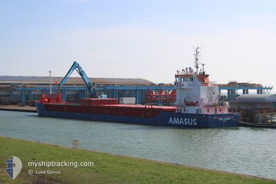
EEMS TJONGER
General Cargo
Current Trip
| Time Travelled | 2 days |
|---|---|
| Remaining Time | 4 h, 27 mins |
| Distance Travelled | 596.06 nm |
| Remaining Distance | 17.41 nm |
| AVG Speed | 7.8 Knots |
| MAX Speed | 11.7 Knots |
| AVG Wind | 8.4 knots |
| MAX Wind | 18.8 knots |
| MIN Temp | 10.9°C / 51.62°F |
| MAX Temp | 14.2°C / 57.56°F |
| Draught | 5.7 m |
| Position Received | 1 m ago |
Current Position
| Longitude | 3.76016° |
|---|---|
| Latitude | 52.10885° |
| Status | Under way using engine |
| Speed | 9.1 Knots |
| Course | 173.7° |
| Area | North Sea |
| Station | T-AIS |
| Position Received | 1 m ago |
Info
Information
The current position of EEMS TJONGER is in North Sea with coordinates 52.10885° / 3.76016° as reported on 2024-05-17 20:15 by AIS to our vessel tracker app. The vessel's current speed is 9.1 Knots and is heading at the port of ROTTERDAM. The estimated time of arrival as calculated by vessel tracking app is 2024-05-18 00:43 LT
The vessel EEMS TJONGER (IMO: 9517240, MMSI: 246869000) is a General Cargo that was built in 2012 ( 12 years old ). It's sailing under the flag of [NL] Netherlands.
In this page you can find informations about the vessels current position, last detected port calls, and current voyage information. If the vessels is not in coverage by AIS you will find the latest position.
The current position of EEMS TJONGER is detected by our AIS receivers and we are not responsible for the reliability of the data. The last position was recorded while the vessel was in Coverage by the Ais receivers of our vessel tracking app.
The current draught of EEMS TJONGER as reported by AIS is 5.7 meters
Weather
| Temperature | 13.2°C / 55.76°F |
|---|---|
| Wind Speed | 13 knots |
| Direction | 330° NNW |
| Pressure | 1009.4 hPa |
| Humidity | 94 % |
| Cloud Coverage | 100 % |
Featured Company
Last Port Calls
| Port | Arrival | Departure | Time In Port |
|---|---|---|---|
| 2024-05-13 22:22 | 2024-05-14 21:15 | 22 h | |
| 2024-05-06 18:35 | 2024-05-11 20:31 | 5 d | |
| 2024-05-01 16:46 | 2024-05-03 09:00 | 1 d | |
| 2024-04-30 16:09 | 2024-05-01 02:56 | 10 h | |
| 2024-04-25 04:26 | 2024-04-25 20:14 | 15 h | |
| 2024-04-23 17:40 | 2024-04-24 18:09 | 1 d | |
| 2024-04-19 19:18 | 2024-04-21 00:17 | 1 d | |
| 2024-04-19 18:35 | 2024-04-19 19:10 | 35 m | |
| 2024-04-16 08:57 | 2024-04-19 11:35 | 3 d | |
| 2024-04-11 09:40 | 2024-04-12 18:40 | 1 d |
Last Trips
| Origin | Departure | Destination | Arrival | Distance | |
|---|---|---|---|---|---|
| 2024-05-11 21:31 | 2024-05-13 23:22 | 96.18 nm | |||
| 2024-05-03 11:00 | 2024-05-06 19:35 | 606.84 nm | |||
| 2024-05-01 04:56 | 2024-05-01 18:46 | 42.97 nm | |||
| 2024-04-25 21:14 | 2024-04-30 18:09 | 547.39 nm | |||
| 2024-04-24 19:09 | 2024-04-25 05:26 | 44.64 nm | |||
| 2024-04-21 02:17 | 2024-04-23 18:40 | 585.74 nm | |||
| 2024-04-19 21:10 | 2024-04-19 21:18 | 0.34 nm | |||
| 2024-04-19 13:35 | 2024-04-19 20:35 | 40.83 nm | |||
| 2024-04-12 20:40 | 2024-04-16 10:57 | 777.47 nm | |||
| 2024-04-10 15:06 | 2024-04-11 11:40 | 185.58 nm |
Events
| Time | Event | Details | Position / Dest | Info |
|---|---|---|---|---|
| 2024-05-17 17:22 | Status Changed | Under way using engine Default |
52.17154 / 3.49416
NLRTM
|
Speed: 5 kn Course: 44° |
| 2024-05-17 17:18 | Status Changed | Default Under way using engine |
52.16667 / 3.48667
NLRTM
|
Speed: 5.9 kn Course: 14.7° |
| 2024-05-17 09:26 | Detected in Sea | Dutch part of the North Sea |
51.77349 / 2.70933
North Sea
NLRTM
|
Speed: 5.5 kn Course: 53.7° |
| 2024-05-17 05:58 | Change Sea Area | Belgian part of the North Sea French part of the North Sea |
51.48194 / 2.28044
North Sea
NLRTM
|
Speed: 8 kn Course: 38.3° |
| 2024-05-17 01:11 | Change Sea Area | French part of the North Sea French part of the English Channel |
50.99835 / 1.62751
North Sea
NLRTM
|
Speed: 7.8 kn Course: 40.5° |
| 2024-05-16 20:43 | Change Sea Area | French part of the English Channel United Kingdom part of the English Channel |
50.53221 / .97634
English Channel
NLRTM
|
Speed: 8.9 kn Course: 77.8° |
| 2024-05-16 12:33 | Status Changed | Under way using engine Default |
50.30287 / -1.08634
NLRTM
|
Speed: 9.3 kn Course: 83° |
| 2024-05-16 12:23 | Status Changed | Default Under way using engine |
50.29972 / -1.12770
NLRTM
|
Speed: 9.5 kn Course: 84.1° |
| 2024-05-16 12:16 | Status Changed | Under way using engine Default |
50.29797 / -1.15346
NLRTM
|
Speed: 9.6 kn Course: 85° |
| 2024-05-16 12:03 | IN Coverage |
50.29797 / -1.15346
English Channel
NLRTM
|
Speed: 9.5 kn Course: 84.1° |