
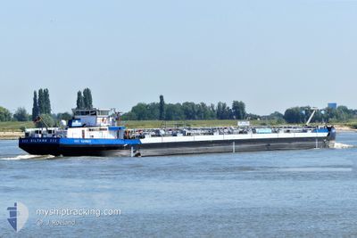
EILTANK 232
Wing in ground
Current Trip
| Time Travelled | 2 days |
|---|---|
| Remaining Time | --- |
| Distance Travelled | 237.04 nm |
| Remaining Distance | --- |
| AVG Speed | 10.7 Knots |
| MAX Speed | 13.2 Knots |
| AVG Wind | 7 knots |
| MAX Wind | 12.8 knots |
| MIN Temp | 8.2°C / 46.76°F |
| MAX Temp | 21.2°C / 70.16°F |
| Draught | 1.9 m |
| Position Received | 1 m ago |
Current Position
| Longitude | 7.03094° |
|---|---|
| Latitude | 50.80679° |
| Status | Moored |
| Speed | |
| Course | --- |
| Area | North Sea |
| Station | T-AIS |
| Position Received | 1 m ago |
Info
Information
The current position of EILTANK 232 is in North Sea with coordinates 50.80679° / 7.03094° as reported on 2024-06-12 12:41 by AIS to our vessel tracker app. The vessel's current speed is 0 Knots
The vessel EILTANK 232 (MMSI: 211491460) is a Wing in ground It's sailing under the flag of [DE] Germany.
In this page you can find informations about the vessels current position, last detected port calls, and current voyage information. If the vessels is not in coverage by AIS you will find the latest position.
The current position of EILTANK 232 is detected by our AIS receivers and we are not responsible for the reliability of the data. The last position was recorded while the vessel was in Coverage by the Ais receivers of our vessel tracking app.
The current draught of EILTANK 232 as reported by AIS is 1.9 meters
Weather
| Temperature | 14.7°C / 58.46°F |
|---|---|
| Wind Speed | 6 knots |
| Direction | 288° WNW |
| Pressure | 1019.2 hPa |
| Humidity | 57.9 % |
| Cloud Coverage | 81 % |
Featured Company
Last Port Calls
| Port | Arrival | Departure | Time In Port |
|---|---|---|---|
| 2024-06-09 18:21 | 2024-06-09 18:25 | 4 m | |
| 2024-06-08 15:40 | 2024-06-09 17:34 | 1 d | |
| 2024-05-31 17:47 | 2024-06-06 22:02 | 6 d | |
| 2024-05-30 08:12 | 2024-05-30 08:15 | 3 m | |
| 2024-05-29 05:43 | 2024-05-30 06:55 | 1 d | |
| 2024-05-29 00:25 | 2024-05-29 04:09 | 3 h | |
| 2024-05-25 15:03 | 2024-05-25 16:46 | 1 h | |
| 2024-05-23 22:13 | 2024-05-25 12:40 | 1 d | |
| 2024-05-22 02:02 | 2024-05-22 19:22 | 17 h | |
| 2024-05-22 00:05 | 2024-05-22 00:36 | 31 m |
Most Visited Ports (Last year)
| Port | Arrivals | |
|---|---|---|
| 49 | ||
| 17 | ||
| 16 | ||
| 11 | ||
| 11 | ||
| 10 |
Last Trips
| Origin | Departure | Destination | Arrival | Distance | |
|---|---|---|---|---|---|
| 2024-06-09 19:34 | 2024-06-09 20:21 | 3.62 nm | |||
| 2024-06-07 00:02 | 2024-06-08 17:40 | 104.77 nm | |||
| 2024-05-30 10:15 | 2024-05-31 19:47 | 103.94 nm | |||
| 2024-05-30 08:55 | 2024-05-30 10:12 | 3.90 nm | |||
| 2024-05-29 06:09 | 2024-05-29 07:43 | 1.89 nm | |||
| 2024-05-25 18:46 | 2024-05-29 02:25 | 304.33 nm | |||
| 2024-05-25 14:40 | 2024-05-25 17:03 | 3.38 nm | |||
| 2024-05-22 21:22 | 2024-05-24 00:13 | 117.65 nm | |||
| 2024-05-22 02:36 | 2024-05-22 04:02 | 7.19 nm | |||
| 2024-05-21 06:36 | 2024-05-22 02:05 | 8.20 nm |
Events
| Time | Event | Details | Position / Dest | Info |
|---|---|---|---|---|
| 2024-06-11 16:40 | Status Changed | Moored Under way using engine |
50.80648 / 7.03091
ROTTERDAM
|
Speed: 0.5 kn Course: 511° |
| 2024-06-11 16:36 | Status Changed | Under way using engine Moored |
50.80587 / 7.03122
ROTTERDAM
|
Speed: 0.7 kn Course: 511° |
| 2024-06-11 16:20 | Status Changed | Moored Under way using engine |
50.80520 / 7.03158
ROTTERDAM
|
Speed: 1 kn Course: 511° |
| 2024-06-11 16:18 | STOP Moving | 1.23 nm, South East of LULSDORF |
50.80483 / 7.03141
ROTTERDAM
|
Speed: 0.2 kn Course: 511° |
| 2024-06-11 15:03 | IN Coverage |
50.62602 / 7.21239
North Sea
ROTTERDAM
|
Speed: 12.2 kn Course: 355.5° |
|
| 2024-06-11 09:44 | OUT of Coverage |
49.98676 / 7.99294
North Sea
ROTTERDAM
|
Speed: 10.9 kn Course: 250° |
|
| 2024-06-11 06:42 | IN Coverage |
49.74345 / 8.45660
North Sea
ROTTERDAM
|
Speed: 11.2 kn Course: 35.7° |
|
| 2024-06-11 05:25 | OUT of Coverage |
49.54818 / 8.41945
North Sea
ROTTERDAM
|
Speed: 11.5 kn Course: 332.1° |
|
| 2024-06-11 04:13 | IN Coverage |
49.36756 / 8.49878
North Sea
ROTTERDAM
|
Speed: 11.9 kn Course: 15.9° |
|
| 2024-06-10 13:34 | OUT of Coverage |
49.26615 / 8.44454
North Sea
ROTTERDAM
|
Speed: 11.5 kn Course: 36.8° |