
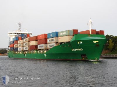
ELBWIND
Container Ship
Current Trip
| Time Travelled | 6 days |
|---|---|
| Remaining Time | 9 h, 22 mins |
| Distance Travelled | 1564.58 nm |
| Remaining Distance | 140.70 nm |
| AVG Speed | 13.9 Knoten |
| MAX Speed | 16.7 Knoten |
| AVG Wind | 9.7 knots |
| MAX Wind | 20 knots |
| MIN Temp | 12.5°C / 54.5°F |
| MAX Temp | 21.5°C / 70.7°F |
| Tiefgang | 8.3 m |
| Position erhalten | 1 m alt |
Current Position
| Länge | 11.34101° |
|---|---|
| Breite | 54.55566° |
| Zustand | Under way using engine |
| Geschwindigkeit | 16 Knoten |
| Kurs | 294.9° |
| Gebiet | Baltic Sea |
| Station | T-AIS |
| Position erhalten | 1 m alt |
Info
Information
Die aktuelle Position von ELBWIND befindet sich in Baltic Sea mit den Koordinaten 54.55566° / 11.34101°, wie von AIS am 2024-06-30 11:56 an unsere Schiffsverfolgungs-App. Die aktuelle Geschwindigkeit des Schiffes betragt 16 Knoten und fahrt in den Hafen von HAMBURG. Die geschatzte Ankunftszeit, berechnet von der -App zur Schiffsverfolgung, ist 2024-06-30 21:19 LT
Das Schiff ELBWIND (IMO: 9483334, MMSI: 210017000) ist Container Ship das wurde im Jahr 2012 ( 12 Jahre alt ) gebaut. Es segelt unter der Flagge [CY] Cyprus.
Auf dieser Seite finden Sie Informationen zur aktuellen Position des Schiffes, zu den zuletzt erkannten Hafenanlaufen und zu aktuellen Reiseinformationen. Wenn die Schiffe nicht von AIS abgedeckt werden, finden Sie die neueste Position.
Die aktuelle Position von ELBWIND wird von unseren AIS-Empfangern erkannt und wir sind nicht fur die Zuverlassigkeit der Daten verantwortlich. Die letzte Position wurde von den Ais-Empfangern unserer Schiffsverfolgungs-App aufgezeichnet, wahrend sich das Schiff in Deckung befand.
Der aktuelle Entwurf von ELBWIND, wie von AIS gemeldet, betragt 8.3 meter
Weather
| Temperature | 17.1°C / 62.78°F |
|---|---|
| Wind Speed | 15 knots |
| Direction | 339° NNW |
| Pressure | 1003.1 hPa |
| Humidity | 92.5 % |
| Cloud Coverage | 100 % |
Featured Company
Last Port Calls
| Port | Arrival | Departure | Time In Port |
|---|---|---|---|
| 2024-06-23 20:22 | 2024-06-23 20:25 | 2 m | |
| 2024-06-20 12:26 | 2024-06-22 16:49 | 2 d | |
| 2024-06-14 20:04 | 2024-06-15 01:11 | 5 h | |
| 2024-06-13 18:17 | 2024-06-14 11:18 | 17 h | |
| 2024-06-13 08:33 | 2024-06-13 11:59 | 3 h | |
| 2024-06-09 15:37 | 2024-06-10 14:56 | 23 h | |
| 2024-06-06 19:19 | 2024-06-07 04:14 | 8 h | |
| 2024-06-05 19:54 | 2024-06-06 11:25 | 15 h | |
| 2024-06-04 17:57 | 2024-06-04 23:28 | 5 h | |
| 2024-06-03 06:29 | 2024-06-04 00:48 | 18 h |
Most Visited Ports (Last year)
| Port | Arrivals | |
|---|---|---|
| 44 | ||
| 19 | ||
| 16 | ||
| 15 | ||
| 13 | ||
| 11 |
Last Trips
| Origin | Departure | Destination | Arrival | Distance | |
|---|---|---|---|---|---|
| 2024-06-22 18:49 | 2024-06-23 22:22 | 320.26 nm | |||
| 2024-06-15 03:11 | 2024-06-20 14:26 | 321.83 nm | |||
| 2024-06-14 13:18 | 2024-06-14 22:04 | 112.58 nm | |||
| 2024-06-13 13:59 | 2024-06-13 20:17 | 81.66 nm | |||
| 2024-06-10 17:56 | 2024-06-13 10:33 | 674.89 nm | |||
| 2024-06-07 06:14 | 2024-06-09 18:37 | 749.98 nm | |||
| 2024-06-06 13:25 | 2024-06-06 21:19 | 110.65 nm | |||
| 2024-06-05 01:28 | 2024-06-05 21:54 | 301.28 nm | |||
| 2024-06-04 02:48 | 2024-06-04 19:57 | 259.30 nm | |||
| 2024-06-03 02:49 | 2024-06-03 08:29 | 83.33 nm |
Events
| Zeit | Ereignis | Details | Position / Ziel | Information |
|---|---|---|---|---|
| 2024-06-30 11:55 | Ändere Seegebiet | German part of the Baltic Sea Danish part of the Baltic Sea |
54.55379 / 11.34791
Baltic Sea
DEHAM VIA NOK
|
Geschwindigkeit: 16 kn Kurs: 294.7° |
| 2024-06-30 09:59 | Ändere Seegebiet | Danish part of the Baltic Sea German part of the Baltic Sea |
54.44641 / 12.13540
Baltic Sea
DEHAM VIA NOK
|
Geschwindigkeit: 14.4 kn Kurs: 267.7° |
| 2024-06-30 09:47 | Ändere Seegebiet | German part of the Baltic Sea Danish part of the Baltic Sea |
54.47081 / 12.19424
Baltic Sea
DEHAM VIA NOK
|
Geschwindigkeit: 15.5 kn Kurs: 194.9° |
| 2024-06-30 07:26 | Ändere Seegebiet | Danish part of the Baltic Sea German part of the Baltic Sea |
54.83474 / 12.92614
Baltic Sea
DEHAM VIA NOK
|
Geschwindigkeit: 14.7 kn Kurs: 252.1° |
| 2024-06-30 05:17 | Ändere Seegebiet | German part of the Baltic Sea Swedish part of the Baltic Sea |
55.01099 / 13.80073
Baltic Sea
DEHAM VIA NOK
|
Geschwindigkeit: 15.7 kn Kurs: 245.3° |
| 2024-06-30 02:26 | Ändere Seegebiet | Swedish part of the Baltic Sea Danish part of the Kattegat |
55.48552 / 14.71990
Baltic Sea
DEHAM VIA NOK
|
Geschwindigkeit: 15 kn Kurs: 236.8° |
| 2024-06-30 01:05 | Ändere Seegebiet | Danish part of the Kattegat Swedish part of the Baltic Sea |
55.64237 / 15.25221
Kattegat
DEHAM VIA NOK
|
Geschwindigkeit: 14.6 kn Kurs: 240° |
| 2024-06-29 16:45 | geänderter Status | Under way using engine Default |
56.83326 / 18.38330
DEHAM VIA NOK
|
Geschwindigkeit: 15.1 kn Kurs: 234° |
| 2024-06-29 16:42 | geänderter Status | Default Under way using engine |
56.84193 / 18.40488
DEHAM VIA NOK
|
Geschwindigkeit: 15 kn Kurs: 232.8° |
| 2024-06-29 16:25 | Auf See entdeckt | Swedish part of the Baltic Sea |
56.89113 / 18.49236
Baltic Sea
DEHAM VIA NOK
|
Geschwindigkeit: 15.3 kn Kurs: 218° |