
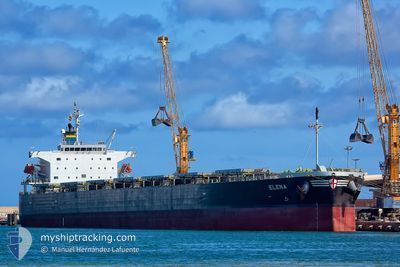
ELENA
Bulk Carrier
Current Trip
| Time Travelled | 1 day |
|---|---|
| Remaining Time | --- |
| Distance Travelled | 271.83 nm |
| Remaining Distance | --- |
| AVG Speed | 10.9 Knots |
| MAX Speed | 12.5 Knots |
| AVG Wind | 6 knots |
| MAX Wind | 10 knots |
| MIN Temp | 17.6°C / 63.68°F |
| MAX Temp | 21°C / 69.8°F |
| Draught | 13.9 m |
| Position Received | 17 h, 14 m ago |
Current Position
| Longitude | 152.11662° |
|---|---|
| Latitude | -33.50602° |
| Status | Under way using engine |
| Speed | 11.3 Knots |
| Course | 48.9° |
| Area | Tasman Sea |
| Station | T-AIS |
| Position Received | 17 h, 14 m ago |
Info
Information
The current position of ELENA is in Tasman Sea with coordinates -33.50602° / 152.11662° as reported on 2024-05-16 10:51 by AIS to our vessel tracker app. The vessel's current speed is 11.3 Knots and is heading at the port of SINGAPORE. The estimated time of arrival as calculated by vessel tracking app is 2024-06-03 12:09 LT
The vessel ELENA (IMO: 9336880, MMSI: 311000157) is a Bulk Carrier that was built in 2009 ( 15 years old ). It's sailing under the flag of [BS] Bahamas.
In this page you can find informations about the vessels current position, last detected port calls, and current voyage information. If the vessels is not in coverage by AIS you will find the latest position.
The current position of ELENA is detected by our AIS receivers and we are not responsible for the reliability of the data. The last position was recorded while the vessel was in Coverage by the Ais receivers of our vessel tracking app.
The current draught of ELENA as reported by AIS is 13.9 meters
Weather
| Temperature | 20.9°C / 69.62°F |
|---|---|
| Wind Speed | 7 knots |
| Direction | 63° ENE |
| Pressure | 1020.9 hPa |
| Humidity | 60.5 % |
| Cloud Coverage | 100 % |
Featured Company
Last Port Calls
| Port | Arrival | Departure | Time In Port |
|---|---|---|---|
| 2024-05-15 13:03 | 2024-05-16 03:11 | 14 h | |
| 2024-04-27 21:57 | 2024-05-01 12:42 | 3 d | |
| 2024-03-19 07:54 | 2024-04-07 02:49 | 18 d |
Most Visited Ports (Last year)
| Port | Arrivals | |
|---|---|---|
| 3 | ||
| 2 | ||
| 1 | ||
| 1 | ||
| 1 | ||
| 1 |
Events
| Time | Event | Details | Position / Dest | Info |
|---|---|---|---|---|
| 2024-05-16 10:51 | Status Changed | Default Under way using engine |
-33.50571 / 152.11703
SG SIN
|
Speed: 11.3 kn Course: 48.9° |
| 2024-05-16 10:51 | Status Changed | Under way using engine Default |
-33.50602 / 152.11662
SG SIN
|
Speed: 11.3 kn Course: 49° |
| 2024-05-16 10:51 | OUT of Coverage |
-33.50602 / 152.11662
Tasman Sea
SG SIN
|
Speed: 11.3 kn Course: 48.9° |
|
| 2024-05-16 10:12 | Status Changed | Default Under way using engine |
-33.58950 / 152.00565
SG SIN
|
Speed: 11.1 kn Course: 47.4° |
| 2024-05-16 05:31 | Draught Changed | 13.9 10.5 |
-34.19417 / 151.29415
SG SIN
|
Speed: 10.5 kn Course: 49.1° |
| 2024-05-16 05:31 | Destination Changed | SG SIN AUPKL |
-34.19417 / 151.29415
SG SIN
|
Speed: 10.5 kn Course: 49.1° |
| 2024-05-16 05:31 | ETA Changed | 2024/06/03 12:09 2024/05/06 19:00 |
-34.19417 / 151.29415
SG SIN
|
Speed: 10.5 kn Course: 49.1° |
| 2024-05-16 04:28 | Status Changed | Under way using engine Default |
-34.31574 / 151.12165
AUPKL
|
Speed: 11.1 kn Course: 52° |
| 2024-05-16 04:03 | Status Changed | Default Under way using engine |
-34.36460 / 151.04695
AUPKL
|
Speed: 11.3 kn Course: 51.6° |
| 2024-05-16 03:38 | Status Changed | Under way using engine Default |
-34.41245 / 150.97167
AUPKL
|
Speed: 10.9 kn Course: 47° |