
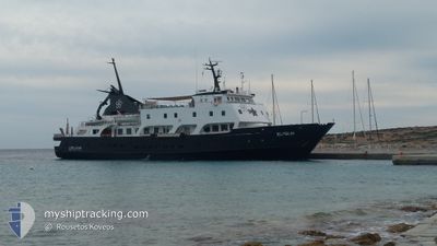
ELYSIUM
Passenger A
Current Trip
| Time Travelled | 3 h, 22 mins |
|---|---|
| Remaining Time | --- |
| Distance Travelled | 25.16 nm |
| Remaining Distance | --- |
| AVG Speed | 9 Knots |
| MAX Speed | 9.6 Knots |
| AVG Wind | 9.4 knots |
| MAX Wind | 11 knots |
| MIN Temp | 19.5°C / 67.1°F |
| MAX Temp | 20.1°C / 68.18°F |
| Draught | 4 m |
| Position Received | 36 m ago |
Current Position
| Longitude | 23.46218° |
|---|---|
| Latitude | 37.35456° |
| Status | Under way using engine |
| Speed | 2.6 Knots |
| Course | 231° |
| Area | Aegean Sea |
| Station | T-AIS |
| Position Received | 36 m ago |
Info
Information
The current position of ELYSIUM is in Aegean Sea with coordinates 37.35456° / 23.46218° as reported on 2024-05-29 05:56 by AIS to our vessel tracker app. The vessel's current speed is 2.6 Knots
The vessel ELYSIUM (IMO: 8112902, MMSI: 341200000) is a Passenger A It's sailing under the flag of [KN] St Kitts Nevis.
In this page you can find informations about the vessels current position, last detected port calls, and current voyage information. If the vessels is not in coverage by AIS you will find the latest position.
The current position of ELYSIUM is detected by our AIS receivers and we are not responsible for the reliability of the data. The last position was recorded while the vessel was in Coverage by the Ais receivers of our vessel tracking app.
The current draught of ELYSIUM as reported by AIS is 4 meters
Weather
| Temperature | 20.1°C / 68.18°F |
|---|---|
| Wind Speed | 4 knots |
| Direction | 261° W |
| Pressure | 1012.6 hPa |
| Humidity | 67.5 % |
| Cloud Coverage | 45 % |
Featured Company
Last Port Calls
| Port | Arrival | Departure | Time In Port |
|---|---|---|---|
| 2024-05-28 15:45 | 2024-05-29 03:11 | 11 h | |
| 2024-05-28 13:27 | 2024-05-28 15:40 | 2 h | |
| 2024-05-28 13:11 | 2024-05-28 13:15 | 3 m | |
| 2024-05-27 09:01 | 2024-05-28 08:09 | 23 h | |
| 2024-05-26 06:04 | 2024-05-26 22:13 | 16 h | |
| 2024-05-25 04:16 | 2024-05-26 03:13 | 22 h | |
| 2024-05-24 14:41 | 2024-05-24 22:00 | 7 h | |
| 2024-05-23 08:09 | 2024-05-23 20:39 | 12 h | |
| 2024-05-22 17:34 | 2024-05-22 18:19 | 44 m | |
| 2024-05-22 07:13 | 2024-05-22 07:56 | 42 m |
Last Trips
| Origin | Departure | Destination | Arrival | Distance | |
|---|---|---|---|---|---|
| 2024-05-28 18:40 | 2024-05-28 18:45 | 0.16 nm | |||
| 2024-05-28 16:15 | 2024-05-28 16:27 | 0.28 nm | |||
| 2024-05-28 11:09 | 2024-05-28 16:11 | 36.52 nm | |||
| 2024-05-27 01:13 | 2024-05-27 12:01 | 68.74 nm | |||
| 2024-05-26 06:13 | 2024-05-26 09:04 | 25.38 nm | |||
| 2024-05-25 01:00 | 2024-05-25 07:16 | 57.26 nm | |||
| 2024-05-23 23:39 | 2024-05-24 17:41 | 68.87 nm | |||
| 2024-05-22 21:19 | 2024-05-23 11:09 | 64.22 nm | |||
| 2024-05-22 10:56 | 2024-05-22 20:34 | 2.55 nm | |||
| 2024-05-22 04:40 | 2024-05-22 10:13 | 45.74 nm |
Events
| Time | Event | Details | Position / Dest | Info |
|---|---|---|---|---|
| 2024-05-29 06:14 | Status Changed | Default Under way using engine |
37.35210 / 23.45868
GRHYD
|
Speed: 2.6 kn Course: 231° |
| 2024-05-29 05:55 | Status Changed | Under way using engine Default |
37.35569 / 23.46341
GRHYD
|
Speed: 7 kn Course: 224° |
| 2024-05-29 05:21 | Status Changed | Default Under way using engine |
37.41299 / 23.53073
GRHYD
|
Speed: 9.3 kn Course: 221.4° |
| 2024-05-29 05:00 | Status Changed | Under way using engine Default |
37.46139 / 23.55679
GRHYD
|
Speed: 9 kn Course: 178° |
| 2024-05-29 04:51 | Status Changed | Default Under way using engine |
37.48333 / 23.55500
GRHYD
|
Speed: 9.6 kn Course: 179.4° |
| 2024-05-29 03:12 | Status Changed | Under way using engine Moored |
37.74057 / 23.54431
GRHYD
|
Speed: 7.7 kn Course: 133.1° |
| 2024-05-29 03:11 | START Moving | 0.18 nm, East of AGIA MARINA |
37.74234 / 23.54198
GRHYD
|
Speed: 4.9 kn Course: 131° |
| 2024-05-29 03:11 | PORT DEPARTURE |
|
37.74234 / 23.54198
GRHYD
|
Speed: 4 kn Course: 136° |
| 2024-05-29 03:01 | ETA Changed | 2024/05/29 06:30 2024/05/29 13:00 |
37.74319 / 23.53978
[GR] AGIA MARINA
|
Speed: Course: 242° |
| 2024-05-29 02:49 | Destination Changed | GRHYD GRAMR |
37.74320 / 23.53977
[GR] AGIA MARINA
|
Speed: Course: 242° |