
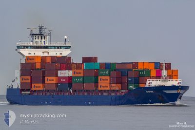
EMPIRE
Container Ship
Current Trip
| Time Travelled | 1 day |
|---|---|
| Remaining Time | 15 h, 13 mins |
| Distance Travelled | 532.68 nm |
| Remaining Distance | 207.34 nm |
| AVG Speed | 13.3 Knots |
| MAX Speed | 15.8 Knots |
| AVG Wind | 10.2 knots |
| MAX Wind | 15.2 knots |
| MIN Temp | 7.8°C / 46.04°F |
| MAX Temp | 13.4°C / 56.12°F |
| Draught | 9.3 m |
| Position Received | 1 m ago |
Current Position
| Longitude | 12.94578° |
|---|---|
| Latitude | 54.84298° |
| Status | Under way using engine |
| Speed | 13.1 Knots |
| Course | 248.7° |
| Area | Baltic Sea |
| Station | T-AIS |
| Position Received | 1 m ago |
Info
Information
The current position of EMPIRE is in Baltic Sea with coordinates 54.84298° / 12.94578° as reported on 2024-05-18 08:54 by AIS to our vessel tracker app. The vessel's current speed is 13.1 Knots and is heading at the port of HAMBURG. The estimated time of arrival as calculated by vessel tracking app is 2024-05-19 00:08 LT
The vessel EMPIRE (IMO: 9387425, MMSI: 245258000) is a Container Ship that was built in 2009 ( 15 years old ). It's sailing under the flag of [NL] Netherlands.
In this page you can find informations about the vessels current position, last detected port calls, and current voyage information. If the vessels is not in coverage by AIS you will find the latest position.
The current position of EMPIRE is detected by our AIS receivers and we are not responsible for the reliability of the data. The last position was recorded while the vessel was in Coverage by the Ais receivers of our vessel tracking app.
The current draught of EMPIRE as reported by AIS is 9.3 meters
Weather
| Temperature | 11°C / 51.8°F |
|---|---|
| Wind Speed | 12 knots |
| Direction | 78° ENE |
| Pressure | 1014 hPa |
| Humidity | 89.4 % |
| Cloud Coverage | 6 % |
Featured Company
Last Port Calls
| Port | Arrival | Departure | Time In Port |
|---|---|---|---|
| 2024-05-15 05:24 | 2024-05-16 16:52 | 1 d | |
| 2024-05-13 19:56 | 2024-05-14 06:17 | 10 h | |
| 2024-05-11 14:49 | 2024-05-13 17:03 | 2 d | |
| 2024-05-09 18:03 | 2024-05-10 05:22 | 11 h | |
| 2024-05-06 19:40 | 2024-05-08 04:24 | 1 d | |
| 2024-05-01 07:58 | 2024-05-02 20:44 | 1 d | |
| 2024-04-29 18:13 | 2024-04-30 07:27 | 13 h | |
| 2024-04-29 02:36 | 2024-04-29 15:11 | 12 h | |
| 2024-04-27 07:51 | 2024-04-27 23:21 | 15 h | |
| 2024-04-24 06:53 | 2024-04-25 20:42 | 1 d |
Last Trips
| Origin | Departure | Destination | Arrival | Distance | |
|---|---|---|---|---|---|
| 2024-05-14 09:17 | 2024-05-15 08:24 | 304.00 nm | |||
| 2024-05-13 20:03 | 2024-05-13 22:56 | 45.21 nm | |||
| 2024-05-10 07:22 | 2024-05-11 17:49 | 433.64 nm | |||
| 2024-05-08 06:24 | 2024-05-09 20:03 | 441.28 nm | |||
| 2024-05-02 23:44 | 2024-05-06 21:40 | 1226.76 nm | |||
| 2024-04-30 10:27 | 2024-05-01 10:58 | 307.43 nm | |||
| 2024-04-29 18:11 | 2024-04-29 21:13 | 44.96 nm | |||
| 2024-04-28 01:21 | 2024-04-29 05:36 | 435.23 nm | |||
| 2024-04-25 22:42 | 2024-04-27 09:51 | 437.18 nm | |||
| 2024-04-21 10:03 | 2024-04-24 08:53 | 744.25 nm |
Events
| Time | Event | Details | Position / Dest | Info |
|---|---|---|---|---|
| 2024-05-18 06:46 | Change Sea Area | German part of the Baltic Sea Swedish part of the Baltic Sea |
55.01674 / 13.71322
Baltic Sea
DEHAM VIA NOK
|
Speed: 13.4 kn Course: 248.4° |
| 2024-05-18 03:35 | Detected in Sea | Swedish part of the Baltic Sea |
55.46112 / 14.68870
Baltic Sea
DEHAM VIA NOK
|
Speed: 13.1 kn Course: 238.2° |
| 2024-05-18 01:59 | Change Sea Area | Danish part of the Kattegat Swedish part of the Baltic Sea |
55.64417 / 15.22656
Kattegat
DEHAM VIA NOK
|
Speed: 13.3 kn Course: 236.6° |
| 2024-05-17 19:16 | Status Changed | Under way using engine Default |
56.61011 / 17.09147
DEHAM VIA NOK
|
Speed: 13.4 kn Course: 200° |
| 2024-05-17 18:28 | Status Changed | Default Under way using engine |
56.77703 / 17.21205
DEHAM VIA NOK
|
Speed: 13.4 kn Course: 201.4° |
| 2024-05-17 18:22 | Status Changed | Under way using engine Default |
56.79718 / 17.22679
DEHAM VIA NOK
|
Speed: 13.4 kn Course: 202° |
| 2024-05-17 18:00 | Status Changed | Default Under way using engine |
56.87411 / 17.28468
DEHAM VIA NOK
|
Speed: 13.4 kn Course: 202.7° |
| 2024-05-17 16:39 | Status Changed | Under way using engine Default |
57.15590 / 17.47913
DEHAM VIA NOK
|
Speed: 13.1 kn Course: 200° |
| 2024-05-17 16:33 | Status Changed | Default Under way using engine |
57.17781 / 17.49395
DEHAM VIA NOK
|
Speed: 13.5 kn Course: 201.9° |
| 2024-05-17 12:57 | OUT of Coverage |
57.88573 / 18.15876
Baltic Sea
DEHAM VIA NOK
|
Speed: 13.4 kn Course: 208.7° |