
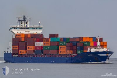
EMPIRE
Container Ship
Current Trip
| Time Travelled | 1 day |
|---|---|
| Remaining Time | 11 h, 29 mins |
| Distance Travelled | 250.12 nm |
| Remaining Distance | 188.29 nm |
| AVG Speed | 9.5 Knots |
| MAX Speed | 16.5 Knots |
| AVG Wind | 5.9 knots |
| MAX Wind | 13 knots |
| MIN Temp | 12.5°C / 54.5°F |
| MAX Temp | 15.1°C / 59.18°F |
| Draught | 9 m |
| Position Received | 1 m ago |
Current Position
| Longitude | 14.32036° |
|---|---|
| Latitude | 54.61028° |
| Status | Under way using engine |
| Speed | 16 Knots |
| Course | 103.6° |
| Area | Baltic Sea |
| Station | T-AIS |
| Position Received | 1 m ago |
Info
Information
The current position of EMPIRE is in Baltic Sea with coordinates 54.61028° / 14.32036° as reported on 2024-05-23 21:48 by AIS to our vessel tracker app. The vessel's current speed is 16 Knots and is heading at the port of GDYNIA. The estimated time of arrival as calculated by vessel tracking app is 2024-05-24 09:18 LT
The vessel EMPIRE (IMO: 9387425, MMSI: 245258000) is a Container Ship that was built in 2009 ( 15 years old ). It's sailing under the flag of [NL] Netherlands.
In this page you can find informations about the vessels current position, last detected port calls, and current voyage information. If the vessels is not in coverage by AIS you will find the latest position.
The current position of EMPIRE is detected by our AIS receivers and we are not responsible for the reliability of the data. The last position was recorded while the vessel was in Coverage by the Ais receivers of our vessel tracking app.
The current draught of EMPIRE as reported by AIS is 9 meters
Weather
| Temperature | 13.2°C / 55.76°F |
|---|---|
| Wind Speed | 13 knots |
| Direction | 263° W |
| Pressure | 1015.6 hPa |
| Humidity | 93.7 % |
| Cloud Coverage | 79 % |
Featured Company
Last Port Calls
| Port | Arrival | Departure | Time In Port |
|---|---|---|---|
| 2024-05-20 16:57 | 2024-05-22 20:20 | 2 d | |
| 2024-05-20 02:02 | 2024-05-20 02:48 | 46 m | |
| 2024-05-15 05:24 | 2024-05-16 16:52 | 1 d | |
| 2024-05-13 19:56 | 2024-05-14 06:17 | 10 h | |
| 2024-05-11 14:49 | 2024-05-13 17:03 | 2 d | |
| 2024-05-09 18:03 | 2024-05-10 05:22 | 11 h | |
| 2024-05-06 19:40 | 2024-05-08 04:24 | 1 d | |
| 2024-05-01 07:58 | 2024-05-02 20:44 | 1 d | |
| 2024-04-29 18:13 | 2024-04-30 07:27 | 13 h | |
| 2024-04-29 02:36 | 2024-04-29 15:11 | 12 h |
Last Trips
| Origin | Departure | Destination | Arrival | Distance | |
|---|---|---|---|---|---|
| 2024-05-20 04:48 | 2024-05-20 18:57 | 88.60 nm | |||
| 2024-05-16 19:52 | 2024-05-20 04:02 | 654.28 nm | |||
| 2024-05-14 09:17 | 2024-05-15 08:24 | 304.00 nm | |||
| 2024-05-13 20:03 | 2024-05-13 22:56 | 45.21 nm | |||
| 2024-05-10 07:22 | 2024-05-11 17:49 | 433.64 nm | |||
| 2024-05-08 06:24 | 2024-05-09 20:03 | 441.28 nm | |||
| 2024-05-02 23:44 | 2024-05-06 21:40 | 1226.76 nm | |||
| 2024-04-30 10:27 | 2024-05-01 10:58 | 307.43 nm | |||
| 2024-04-29 18:11 | 2024-04-29 21:13 | 44.96 nm | |||
| 2024-04-28 01:21 | 2024-04-29 05:36 | 435.23 nm |
Events
| Time | Event | Details | Position / Dest | Info |
|---|---|---|---|---|
| 2024-05-23 17:14 | Change Sea Area | German part of the Baltic Sea Danish part of the Baltic Sea |
54.58764 / 12.32963
Baltic Sea
GDYNIA
|
Speed: 15.5 kn Course: 54.4° |
| 2024-05-23 17:11 | Change Sea Area | Danish part of the Baltic Sea German part of the Baltic Sea |
54.57967 / 12.31324
Baltic Sea
GDYNIA
|
Speed: 15.7 kn Course: 36.6° |
| 2024-05-23 16:20 | Change Sea Area | German part of the Baltic Sea Danish part of the Baltic Sea |
54.40978 / 12.11292
Baltic Sea
GDYNIA
|
Speed: 15.8 kn Course: 91.1° |
| 2024-05-23 14:41 | Change Sea Area | Danish part of the Baltic Sea German part of the Baltic Sea |
54.51166 / 11.42677
Baltic Sea
GDYNIA
|
Speed: 16.2 kn Course: 117.1° |
| 2024-05-23 13:11 | Change Sea Area | German part of the Baltic Sea Danish part of the Baltic Sea |
54.56847 / 10.77810
Baltic Sea
GDYNIA
|
Speed: 16.3 kn Course: 83.4° |
| 2024-05-23 12:50 | Change Sea Area | Danish part of the Baltic Sea German part of the Baltic Sea |
54.55622 / 10.61646
Baltic Sea
GDYNIA
|
Speed: 15.8 kn Course: 81.1° |
| 2024-05-23 12:29 | ETA Changed | 2024/05/24 10:00 2024/05/24 11:00 |
54.52289 / 10.47011
GDYNIA
|
Speed: 15.9 kn Course: 58.7° |
| 2024-05-23 11:59 | Change Sea Area | German part of the Baltic Sea German part of the North Sea |
54.46498 / 10.27978
Baltic Sea
GDYNIA
|
Speed: 15.9 kn Course: 41.6° |
| 2024-05-23 11:16 | START Moving | 1.34 nm, South West of STICKENHΟRN SPORT |
54.36597 / 10.14320
GDYNIA
|
Speed: 4 kn Course: 106° |
| 2024-05-23 10:15 | STOP Moving | 1.39 nm, South West of STICKENHΟRN SPORT |
54.36644 / 10.14022
GDYNIA
|
Speed: 0.1 kn Course: 110° |