
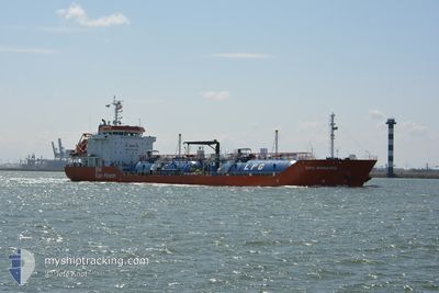
EPIC BONAIRE
Tanker B
Current Trip
| Time Travelled | 1 day |
|---|---|
| Remaining Time | 2 days |
| Distance Travelled | 330.69 nm |
| Remaining Distance | 659.54 nm |
| AVG Speed | 8.9 Knots |
| MAX Speed | 12.2 Knots |
| AVG Wind | 22.4 knots |
| MAX Wind | 35.8 knots |
| MIN Temp | 14.8°C / 58.64°F |
| MAX Temp | 20.6°C / 69.08°F |
| Draught | 5.2 m |
| Position Received | 1 d ago |
Current Position
| Longitude | -9.71620° |
|---|---|
| Latitude | 41.95451° |
| Status | Under way using engine |
| Speed | 8.3 Knots |
| Course | 327.9° |
| Area | North Atlantic Ocean |
| Station | T-AIS |
| Position Received | 1 d ago |
Info
Information
The current position of EPIC BONAIRE is in North Atlantic Ocean with coordinates 41.95451° / -9.71620° as reported on 2024-05-31 17:55 by AIS to our vessel tracker app. The vessel's current speed is 8.3 Knots and is heading at the port of ROTTERDAM. The estimated time of arrival as calculated by vessel tracking app is 2024-06-04 05:05 LT
The vessel EPIC BONAIRE (IMO: 9743253, MMSI: 566017000) is a Tanker B It's sailing under the flag of [SG] Singapore.
In this page you can find informations about the vessels current position, last detected port calls, and current voyage information. If the vessels is not in coverage by AIS you will find the latest position.
The current position of EPIC BONAIRE is detected by our AIS receivers and we are not responsible for the reliability of the data. The last position was recorded while the vessel was in Coverage by the Ais receivers of our vessel tracking app.
The current draught of EPIC BONAIRE as reported by AIS is 5.2 meters
Weather
| Temperature | 14.8°C / 58.64°F |
|---|---|
| Wind Speed | 17 knots |
| Direction | 51° NE |
| Pressure | 1026.8 hPa |
| Humidity | 82.7 % |
| Cloud Coverage | 4 % |
Featured Company
Last Port Calls
| Port | Arrival | Departure | Time In Port |
|---|---|---|---|
| 2024-05-30 08:46 | 2024-05-31 09:22 | 1 d | |
| 2024-05-22 21:16 | 2024-05-24 10:54 | 1 d | |
| 2024-05-18 07:16 | 2024-05-19 13:34 | 1 d | |
| 2024-05-12 18:41 | 2024-05-14 07:50 | 1 d | |
| 2024-05-08 10:05 | 2024-05-09 11:11 | 1 d | |
| 2024-05-03 00:56 | 2024-05-04 14:11 | 1 d | |
| 2024-04-28 18:14 | 2024-04-29 17:17 | 23 h | |
| 2024-04-23 05:45 | 2024-04-25 01:17 | 1 d | |
| 2024-04-17 06:34 | 2024-04-18 07:42 | 1 d | |
| 2024-04-11 21:38 | 2024-04-13 09:34 | 1 d |
Most Visited Ports (Last year)
| Port | Arrivals | |
|---|---|---|
| 29 | ||
| 27 | ||
| 1 |
Last Trips
| Origin | Departure | Destination | Arrival | Distance | |
|---|---|---|---|---|---|
| 2024-05-24 12:54 | 2024-05-30 09:46 | 1013.07 nm | |||
| 2024-05-19 14:34 | 2024-05-22 23:16 | 998.87 nm | |||
| 2024-05-14 09:50 | 2024-05-18 08:16 | 1009.39 nm | |||
| 2024-05-09 12:11 | 2024-05-12 20:41 | 997.67 nm | |||
| 2024-05-04 16:11 | 2024-05-08 11:05 | 1011.11 nm | |||
| 2024-04-29 18:17 | 2024-05-03 02:56 | 998.20 nm | |||
| 2024-04-25 03:17 | 2024-04-28 19:14 | 1009.01 nm | |||
| 2024-04-18 08:42 | 2024-04-23 07:45 | 1006.82 nm | |||
| 2024-04-13 11:34 | 2024-04-17 07:34 | 1016.20 nm | |||
| 2024-04-06 17:41 | 2024-04-11 23:38 | 66.93 nm |
Events
| Time | Event | Details | Position / Dest | Info |
|---|---|---|---|---|
| 2024-05-31 18:00 | Status Changed | Default Under way using engine |
41.96458 / -9.72339
PTAVE>NLRTM
|
Speed: 8.3 kn Course: 327.9° |
| 2024-05-31 17:55 | OUT of Coverage |
41.95451 / -9.71620
North Atlantic Ocean
PTAVE>NLRTM
|
Speed: 8.3 kn Course: 327.9° |
|
| 2024-05-31 17:53 | Status Changed | Under way using engine Default |
41.94940 / -9.71229
PTAVE>NLRTM
|
Speed: 7.9 kn Course: 329° |
| 2024-05-31 17:42 | Status Changed | Default Under way using engine |
41.92833 / -9.69667
PTAVE>NLRTM
|
Speed: 8.6 kn Course: 333.2° |
| 2024-05-31 16:46 | Change Sea Area | Spanish part of the North Atlantic Ocean Portuguese part of the North Atlantic Ocean |
41.80297 / -9.61327
North Atlantic Ocean
PTAVE>NLRTM
|
Speed: 9.7 kn Course: 332.3° |
| 2024-05-31 15:11 | Status Changed | Under way using engine Default |
41.54520 / -9.45245
PTAVE>NLRTM
|
Speed: 11.4 kn Course: 334° |
| 2024-05-31 14:59 | Status Changed | Default Under way using engine |
41.51076 / -9.42939
PTAVE>NLRTM
|
Speed: 11.3 kn Course: 331.2° |
| 2024-05-31 14:54 | Status Changed | Under way using engine Default |
41.49529 / -9.41879
PTAVE>NLRTM
|
Speed: 11 kn Course: 330° |
| 2024-05-31 14:51 | Status Changed | Default Under way using engine |
41.48833 / -9.41333
PTAVE>NLRTM
|
Speed: 11.4 kn Course: 330.4° |
| 2024-05-31 09:22 | PORT DEPARTURE |
|
40.64297 / -8.76057
PTAVE>NLRTM
|
Speed: 8.8 kn Course: 236° |